Challenges of fecal analyses (Round 1)

By Leila Lemos, Ph.D. Student, Department of Fisheries and Wildlife, OSU

Fieldwork is done for the year and lab analyses just started with some challenges. This is not unexpected since no previous hormonal analysis has been conducted with any gray whale tissue, and whale fecal sample analysis is a relatively new technique. So, I have been thinking, learning, consulting, and creating a methodology as I go along. I am grateful to the expert advice and help from many great collaborators:

  • Kathleen Hunt (Northern Arizona University, AZ, United States)
  • Shawn Larson (Seattle Aquarium, WA, United States)
  • Amy Green (Seattle Aquarium, WA, United States)
  • Rachel Ann Hauser-Davis (Fiocruz, RJ, Brazil)
  • Maziet Cheseby (Oregon State University, OR, United States)
  • Scott Klasek (Oregon State University, OR, United States)

I have learned that an important step before undertaking fecal a hormonal analysis is the desalting process of the samples since salts can interfere in hormonal determinations, leading to false results. In order to remove salt content, each sample was first filtered (Fig. 1A), to remove a majority of the salt water content (Fig. 1B) that is inevitably collected along with the fecal sample. Each sample was then re-suspended in ultra-pure water, to dilute the remaining salt content in a higher water volume (Fig. 1C).

Figure 1: Analytical processes: (A) Filtration of the samples; (B) Result from filtration; (C) Addition of pure water to the samples.

After these steps were completed for each sample, the samples were centrifuged (Fig. 2A) to  precipitate the fecal matter and leave the lighter salt ions in the supernatant (the liquid lying above a solid residue; Fig. 2B). After finishing these two phases, the water was removed with aid of a plastic pippete (Fig. 2C), and I was left with only desalted fecal at the bottom of the tubes (Fig. 2D).

Figure 2: Analytical processes: (A) Samples centrifugation; (B) Result from the centrifugation; (C, D) Results from separating water and sample.

The fecal samples were then frozen at -80°C (Fig. 3A & 3B) and then freeze-dried on a lyophilizer for 2 days to remove all remaining water content (Fig. 3C). Finally, I have what I need: desalted, dry fecal samples, ready for hormone analysis (Fig. 3D).

Figure 3: Analytical processes: (A) Freezing process of the samples; (B) Frozen samples ready to go to the lyophilizer; (C) Samples in the lyophilizer; (D) Final result of the lyophilizing process.

Writing this now, this process seems simple, but it was laborious, and took time to find the equipment needed at the right times. The end product is crucial to get a good final result, so my time investment (and my own increased stress level!) was worth it. This type of analysis is very new for marine mammals and our research lab is still in the learning the best methods. Along the way we were unsure of some decisions, some mistakes were made, and we were afraid of losing precious fecal material. But, this is the fun and challenge of working with a new species and new type of sample and, importantly, we have developed a working protocol that should make the process more efficient and reduce our stress levels next time around.

At the end of this sample preparation process, our 53 samples look great and are ready to be analyzed during my training at the Seattle Aquarium. We are also planning to analyze the water that was removed from the samples (Fig. 2D) to see if any hormone leached out from the poop into the water.

Results from this process will aid in future whale fecal hormone studies. Perhaps only the centrifugation step is needed and we can discard the water without losing hormone content. Or, perhaps we need to analyze both portions of the sample and sum the hormones found in each. We shall know the answer when we get our hormone metabolite results. Just another protocol to be worked out as I move ahead with the hormone analysis of these fecal samples. And through all these challenges I keep the end goal of this work in my mind: to learn about the reproductive and stress hormonal variation in gray whales and to link these variations to nutritional status and noise events. Onward!


Good news: You are Brilliant, the Earth is Hiring

By: Erin Pickett, M.S. Student, Oregon State University

GEMM lab UPDATE: Amanda Holdman successfully defended her master’s thesis this week!

Amanda wisely planned her defense date for November 7th, 2016, the day before Election Day. As I anxiously watched the New York Times election forecast needle bounce back and forth, from left to right on Election night, I thought to myself, why didn’t I think of that? If you are unfamiliar with what I am talking about, this “forecast needle” was an animated graphic on the NYT website that bounced constantly all night between the two Presidential candidates. It caused a great deal of unease for those of us that found it difficult to look away. The animation sparked some debate online among bloggers and tweeters, my favorite comment being, “it borders on irresponsible data visualization”. I came to the realization pretty quickly on Tuesday night that despite the outcome of the election, I would still need to turn in my thesis the following week.

Personally, I did not feel motivated to get out of bed on Wednesday. I wasn’t feeling inspired, or overcome with positive thoughts about what my day of thesis writing would bring. Thankfully, here at OSU, we graduate students have good leaders to keep us on track. Wednesday afternoon, we received an encouraging email from our Department Head, Dr. Selina Heppell. I took away two important points from this email. The first: stay positive, and remember that we do great work with great people and that our work matters. Secondly, think about the lessons that we have learned from this election. For those of us that were shocked about who our country has chosen as the next President of the United States, one important lesson is that we need to focus more on engaging people who exist outside of the echo chambers of our scientific communities.

The recent election has left many scientists and environmentalists concerned about what the future political climate will bring in terms of research funding, job opportunities, and environmental protection. More so now than ever it is important to remain positive and hopeful, and to reconsider the way we communicate our research and engage outside communities whose views are unlike our own. Both of these tasks are particularly challenging due to the long list of environmental problems we face. As it turns out, having a hopeful outlook is important for tackling seemingly insurmountable conservation issues, and empowering others to want to do the same (Swaisgood & Sheppard 2010, Garnett & Lindenmayer 2011).

The title of this blog comes from an eloquent commencement speech by Paul Hawken about the importance of remaining optimistic when the data tells us otherwise. While the address was given to the University of Portland class of 2009, I think it is worth reading because it is a relevant and moving reminder of why hope is important.

But, before you read that, take a look at what has been done recently to protect biodiversity around the world-

Photo credit: Mark Sullivan NMFS Permit 10137-07/NOAA

President Obama quadrupled the size of a marine national monument in Hawaii. You can read more about the significance of this monument, called Papahānaumokuākea, in a previous blog of mine.

Photo credit: Northeast U.S. canyons expedition science team and NOAA Okeanos Explorer Program (2013)

Soon after announcing the expansion of Papahānaumokuākea, President Obama established the first marine national monument in the Atlantic. You can read more about the aptly named Northeast Canyons and Seamounts Marine National Monument here.

Photo credit:  Ari Friedlaender

And finally, to top it off, an international body comprised of 24 countries, called the Commission for the Conservation of Antarctic Marine Living Resources, recently came to a consensus to designate a vast portion of the Antarctic’s remote Ross Sea as the world’s largest marine reserve.


References

  • Garnett, S. T., & Lindenmayer, D. B. (2011). Conservation science must engender hope to succeed. Trends in Ecology & Evolution, 26(2), 59-60.
  • Swaisgood, R. R., & Sheppard, J. K. (2010). The culture of conservation biologists: Show me the hope!. BioScience, 60(8), 626-630.


“Evolution”: a board game review

By Florence Sullivan MSc student, Department of Fish and Wildlife.

Another grad student once told me that in order to survive grad school, I would need three things:

(1) an exercise routine, (2) a pet, and (3) a hobby. My Pilates class on Wednesdays is a great mid-week reminder to stretch. I don’t have a pet, so that advice gets fulfilled vicariously through friends. As for my hobby, I think you’ll find that even when scientists take a break from work, we really don’t get that far away from the subject matter…..

Board games have evolved significantly since the early ‘90s when I grew up on such family staples as Monopoly, Risk, Sorry!, Candyland, and Chutes and Ladders, etc. Now, table-top games tend to fall into three loose categories – “Euro-games” that focus on strategy and economic themes as well as keeping all players in the game until the end, “American-style” that tend toward luck and direct player contact so that not everyone plays until the end, and “Party” that are easy to learn and are often played in large groups as social icebreakers or to provide entertainment.

img_20161106_200251024
A few of my favorite games.

As board games proliferate, we see the use of many themes and often, there are valuable educational lessons included in the game design!  There are militaristic or survival games (Betrayal at the House on the Hill, Dead of Winter), economic and engineering (Settlers of Catan, Istanbul, Ticket to ride, Carcassonne), fantasy and art (Small World, Dixit), cooperative vs competitive (Hanabi, Forbidden Desert vs. 7 Wonders), and some of my favorites – the sciences (Compounded, Bioviva, Pandemic).

Today, let’s talk about my current favorite – Evolution. It is immediately obvious that the game designers responsible are either giant nerds (I use this in the most loving way possible) or have spent some quality time with ecologists.  Not only is the art work beautiful, and the game play smooth, but the underlying mechanics allow serious ecological theories such as ‘predator and prey mediated population cycles’, ‘co-evolution’ and ‘evolutionary arms-races’ to be acted out and easily understood.

Players set up their species around the watering hole, and contemplate their next moves.
Players set up their species (1 green/yellow tile = 1 species) around the watering hole, and contemplate their next moves.

In game play, as in life, the point of the game is to eat – victory is achieved by the player who has managed to ‘digest’ the most food tokens. All players begin with a single species, and with each turn, can either add traits (ie. fat tissue, scavenger, etc.) to the species, increase the body size of a species, gain a population level, or gain additional species.  Next, players take food from a limited, random supply until there is no food left. Species that have not been fed to their full capacity (population levels) will starve, and can even become extinct – much like the reality of environmental cycles.  Finally, all food that has been ‘eaten’ is digested, and the next round begins.

Since a player can never be sure how much food will appear on the watering hole each turn, it is a good strategy to capitalize on traits like foraging which allows a species to take twice as much food every time it feeds.  If your species cooperates with another, that means that it gets to eat every time you feed the first species. A player who combines foraging traits with multiple cooperating species in a “cooperation chain” can quickly empty the watering hole before any other players get a chance.  Much like a species perfectly adapted to its niche in the real world will out compete more generalist species.

img_20161106_195009550
The pack-hunting carnivore on the left can easily take down the fertile defensive herding species in the upper right. The efficient foraging species in the middle is protected by its horns, and cooperates with the next species to the right. The burrowing species is protected from carnivores only as long as it is full (and presumably no longer needs to venture out of its burrow).

One way to avoid the competition for food at the watering hole is to play the carnivore trait.  This species must now consume other species in order to feed itself.  A few caveats; a carnivore must be larger in body size than anything it tries to eat, and can no longer eat plant food as it is an obligate carnivore. As soon as a carnivore appears on the board, the evolutionary arms-race begins in earnest!  Traits such as burrowing, climbing, hard shells, horns, defensive herding and warning calls become vital to survival.  But carnivores can be clever, and apply ambush to species with warning call, or pack-hunting to a species with defensive herding.  In everything, there is a certain balance, and quickly, players will find themselves acting out a classic ‘boom and bust population growth cycle’ scenario, where herbivores go extinct due to low food supply at the watering hole and/or high predation pressure, and carnivores soon follow when there are no un-protected species for them to feed upon.

img_20161106_195518519
A flying creature must first pay the ‘upkeep cost’ of its body size in food, before it can feed its population. Good thing it has the extra cliff-side food source that is only accessible to other species with wings!

An expansion has been released for the game – it is called Flight – and introduces traits such as flight, camouflage, good eyesight, and others.  From an ecologist’s perspective, it fits the original game well both scientifically and thematically.  To achieve flight, a higher price must be paid (in terms of cards discarded) to gain the trait card, and unlike other species, an ‘upkeep cost’ must be gathered in food tokens before the species actually eats any food tokens during the round.  However, flight also gives access to a cliff-side watering hole that is not accessible to earthbound species. This neatly mirrors the real world where flight is an energetically costly activity that also opens new niches.

The next expansion is just arriving in stores, and I can’t wait to play it! It’s called Climate, and adds traits such as nocturnal, claws, and insectivore. Perhaps more exciting though, are the ‘event cards’ which will trigger things like desertification, cold snaps, heatwaves, volcanic eruptions and meteor strikes. A climate tracker will keep track of whether the planet is in an ice age or a warming period, and certain traits will make your species more or less likely to survive – can you guess which ones might be useful in either scenario? I think it will be enormously fun to play through different climate scenarios and see how traits stack and species interactions evolve.  Perhaps this new addition to the game will even cause a new game review in Nature – check out their initial assessment here: http://www.nature.com/nature/journal/v528/n7581/full/528192a.html

Games like evolution are useful thought exercises for students and researchers because they promote discussion of adaptive traits, predator-prey cycles, climate, and ecosystem dynamics as related to our own projects. Watching a story unfold in front of you is a great way to truly understand some of the core principles of ecology (and other subjects). This is especially relevant in the GEMM lab where we continuously ask ourselves why our study species act the way they do? How do they find prey, and how are/will they adapt(ing) to our changing climate?

Assembling a Toolbox

By Dawn Barlow, MSc student, Oregon State University

toolbox
Source: https://www.ohrd.wisc.edu/home/portals/0/toolbox.jpg

The season has shifted since the post I wrote this summer about diving into the world of New Zealand blue whales and the beginnings of my masters research. My fieldwork will take place during the upcoming austral summer, which will require me to miss the winter term here on campus. This quarter, I have put my research on the back burner for the time being in favor of a full load of coursework. But my project is still there, simmering subtly and persistently, and giving relevance to the coursework that I’m focusing my energy on this fall term.

As an undergraduate student, I acquired a broad scientific background and had the opportunity to dabble in the areas of biology that piqued my interest. I arrived here with a basic understanding of chemistry, physics, cell biology, anatomy, marine ecology and conservation biology. I gained experience working in the field with intertidal sea stars, snails, mussels, crabs and barnacles, with bottlenose dolphins and with humpback whales. But now my focus has narrowed as I’ve honed in on the specific questions that I will pursue over the next two years. My passion lies in marine ecology and conservation. Now, as a graduate student studying the ecology of a little-known population in a highly industrial area, this passion can come to fruition. For my masters, I hope to do the following:

A) Use photo-identification analysis to obtain a population abundance estimate for blue whales in New Zealand

B) Investigate blue whale residency and distribution patterns in New Zealand waters

C) Develop a comprehensive blue whale habitat use model for the South Taranaki Bight region of New Zealand, which incorporates physical and biological data

Down the road I hope to have implemented a capture-recapture abundance estimate model that best fits the dynamics of this population of blue whales, to have mapped where sightings have occurred and where the highest densities of blue whales are found in both space and time, and to have paired blue whale presence and absence with prey distribution, remote-sensed environmental data, and in situ oceanographic data. But how does one accomplish these things? I need a toolbox to draw from. And so this fall, I am assembling my toolbox, learning programs and analytical skills. I am taking methods courses—statistics, data management in R, analysis in GIS, methods in physiology and behavior of marine megafauna—that are no longer explorations into the world of natural science, but rather tools for exploring, identifying, and interpreting specific phenomena in ecology. While each comes with its own hiccups and headaches (see Florence’s post about this…), they are powerful tools.

Aside from coursework, the research I’m conducting has gained weight and relevance beyond being an investigation in ecology. My study area lies in the South Taranaki Bight of New Zealand, which is a contentious proposed seabed mining site for iron sands. As an undergraduate student I read case studies and wrote papers on the environmental impacts of industry, and I decided to go graduate school because I want to do research that has direct conservation applications. Last week I compiled all the data I’ve processed on blue whale sightings, seasonal residency, and photo identification for the South Taranaki Bight, which will be included as evidence submitted in environmental court in New Zealand by my advisor, Dr. Leigh Torres. “Applied conservation science” has been an abstract idea that has excited and motivated me for a long time, and now I am partaking in this process, experiencing applied conservation science firsthand.

And so my toolbox is growing, and the scope of my work is simultaneously narrowing in focus and expanding in relevance. The more tools I acquire, the more excited I am to apply them to my research. As I build my toolbox this fall, this process is something I look forward to enhancing while I’m in the field, when I dig deeper into data analysis, and as I grow as a conservation scientist.

A blue whale dives in the South Taranaki Bight, New Zealand. Photo by Leigh Torres.

The seamounts are calling and I must go: a humpback’s landscape

Solène Derville, Entropie Lab, Institute of Research for Development, Nouméa, New Caledonia (Ph.D. student under the co-supervision of Dr. Leigh Torres)

The deep ocean is awe-inspiring: vast, mysterious, and complex… I can find many adjectives to describe it, yet the immensity of it prevents me from picturing it in my mind. Landscapes are easy to imagine because we see them all the time, but their hidden ocean counterparts of seascapes with several kilometer-high seamounts and abyssal trenches are hard to visualize.

When I started a PhD on the spatial ecology of humpback whales, a species typically known for its coastal distributions, I never imagined my research would lead me to seamounts. Lesson of the day: you never know where research will lead you… So here is how it happened.

About twenty years ago when my supervisor, Dr Claire Garrigue, started working on humpback whales in New Caledonia, she was told by fishermen that humpbacks were often observed in prime fishing locations, about 170 km south of the mainland. After a little more investigation into this claim, it was discovered that these fishing spots corresponded with two seafloor topographic features: the Antigonia seamount and Torch Bank (Fig. 1), These features rise from the seafloor to depths of 30 m and 60 m respectively and are surrounded by waters about 1500 m deep. This led Dr. Garrigue to implement an ARGOS-satellite tagging program to follow the movements of humpbacks leaving the South Lagoon (one of the main breeding area in New Caledonia, Fig. 1). Sure enough, most of the tagged whales (61%) visited the Antigonia seamount (Fig. 2; Garrigue et al. 2015)⁠.

Map of New Caledonia and our study areas: the South Lagoon and the Southern Seamounts. Light grey lines represent 200m isobaths. Land is shown in black and reefs in grey.
Figure 1: Map of New Caledonia and our study areas: the South Lagoon and the “Southern Seamounts”. Light grey lines represent 200m isobaths. Land is shown in black and reefs in grey.
Figure 2: ARGOS tracking of 34 humpback whales tagged between 2007 and 2012 in the South Lagoon. The Antigonia seamount and Torch Bank are completely covered by tracklines.


Seamounts are defined as “undersea mountains rising at least 100m from the ocean seafloor” (Staudigel et al. 2010). Most of them have a volcanic origin and the majority of them are located in the Pacific Ocean (Wessel 2001). But what is the link between these structures and marine life? The physical and biological mechanisms by which seamounts attract marine wildlife are diverse (for a review see: Pitcher et al. 2008)⁠. In a nutshell, topography of the ocean floor influences water circulation and isolated seabed features such as seamounts affect vertical mixing and create turbulences, consequently resulting in higher productivity.

For instance, have you ever heard of internal waves? Contrary to the surface waves people play in at the beach, internal waves propagate in three dimensions within the water column and can reach heights superior to a 100m! When these waves encounter steep topography, they break, similar to what a “normal” wave would do when reaching shore. This creates complex turbulence, which in turn may attract megafauna such as cetaceans (see com. by Hans van Haren).

The importance of seamounts for cetaceans is often referenced in the literature, however, few studies have tried to quantify this preference (one of which was recently published by our labmate Courtney Hann, see Hann et al. 2016 for details). So what importance do these seamounts serve for humpback whales in New Caledonia? Are they breeding grounds, do they serve as a navigation cue, a resting area, or even a foraging spot (the latter being the less likely hypothesis given that humpback whales have never been observed feeding in tropical waters)?

To answer this question, an expedition to Antigonia was organized in 2008 and about 40 groups of whales were observed in only 7 days! The density of this aggregation, the high occurrence of groups with calves and the consistent singing of males suggested that this area may be associated with breeding or calving behavior. Several other missions followed, confirming the importance of this offshore habitat for humpbacks.

Looking through all this data I was struck by two things: 1) whales were densely aggregated on top of these seamounts but were rarely found in the surrounding area (Fig. 3), and 2) other seamounts with similar characteristics are only a few kilometers from Antigonia, but seem to be rarely visited by tagged whales.

What is so special about these seamounts? Why would energetically depleted females with calves choose to aggregate in these off-shore, densely occupied and unsheltered waters?


Figure 3: 3D surface plot of the seabed in the Southern seamount area. Humpback whale groups observed in-situ during the boat-based surveys conducted between 2001 and 2011 are projected at the surface of the seabed: blue points represent groups without calf and white points represent groups with calf. Antigonia and Torch Bank have a clear flat-top shaped which classifies them in the “guyot” seamount type. Most whale groups aggregated on top of these guyots.
Figure 3: 3D surface plot of the seabed in the Southern Seamounts area. Humpback whale groups observed during the boat-based surveys (2001-2011) are projected at the surface of the seabed: blue points represent groups without calf and white points represent groups with calf. Antigonia and Torch Bank have a clear flat-top shaped and are called “guyots” seamounts. Most whale groups aggregated on top of these guyots. For 3D interactive plot: click here.

I will spend the next two months at the GEMM lab in Newport, OR, trying to answer these questions using ocean models developed by New Caledonian local research teams (at IRD and Ifremer). I will be comparing maps of local currents and topography of several seabed features located south of the New Caledonia main island. The oceanographic model used for this study will allow me to analyze a great number of environmental variables (temperature, salinity, vertical mixing, vorticity etc.) through the water column (one layer every 10m, from 0 to 500m deep) and at a very fine spatio-temporal scale (1km and 1day, even 1 hour at specific discrete locations) to better understand humpback whale habitat preferences.

Figure 4: Modeled Sea Surface Temperature for July 15th 2013 (model in progress, based on MARS3D, development by Romain Legendre). A temperature front occurs in the middle of the study area, along the Norfolk ridge. On this image, a cold eddy is forming right on top of the Antigonia seamount.
Figure 4: Modeled Sea Surface Temperature for July 15th 2013 (model in progress, based on MARS3D, development by Romain Le Gendre). A temperature front occurs in the middle of the study area, along the Norfolk ridge. On this image, a cold eddy is forming right on top of the Antigonia seamount.


Looking forward to uncovering the mysteries of seamounts and sharing the results in December!

Literature Cited

Garrigue C, Clapham PJ, Geyer Y, Kennedy AS, Zerbini AN (2015) Satellite tracking reveals novel migratory patterns and the importance of seamounts for endangered South Pacific Humpback Whales. R Soc Open Sci

Hann CH, Smith TD, Torres LG (2016) A sperm whale’s perspective: The importance of seasonality and seamount depth. Mar Mammal Sci:1–12

Pitcher TJ, Morato T, Hart PJ, Clark MR, Haggan N, Santos RS (2008) Seamounts: ecology, fisheries & conservation. Oxford, UK: Blackwell Publishing Ltd.

Wessel P (2001) Global distribution of seamounts inferred from gridded Geosat/ERS-1 altimetry. J Geophys Res 106:19431–19441

Staudigel H, Koppers AP, Lavelle JW, Pitcer TJ, Shank TM (2010) Defining the word ‘seamount’. Oceanography 23,20–21.

The five senses of fieldwork

By Leila Lemos, PhD student


This summer was full of emotions for me: I finally started my first fieldwork season after almost a year of classes and saw my first gray whale (love at first sight!).

During the fieldwork we use a small research vessel (we call it “Red Rocket”) along the Oregon coast to collect data for my PhD project. We are collecting gray whale fecal samples to analyze hormone variations; acoustic data to assess ambient noise changes at different locations and also variations before, during and after events like the “Halibut opener”; GoPro recordings to evaluate prey availability; photographs in order to identify each individual whale and assess body and skin condition; and video recordings through UAS (aka “drone”) flights, so we can measure the whales and classify them as skinny/fat, calf/juvenile/adult and pregnant/non-pregnant.

However, in order to collect all of these data, we need to first find the whales. This is when we use our first sense: vision. We are always looking at the horizon searching for a blow to come up and once we see it, we safely approach the animal and start watching the individual’s behavior and taking photographs.

If the animal is surfacing regularly to allow a successful drone overflight, we stay with the whale and launch the UAS in order to collect photogrammetry and behavior data.

Each team member performs different functions on the boat, as seen in the figure below.

Figure 1: UAS image showing each team members’ functions in the boat at the moment just after the UAS launch.


While one member pilots the boat, another operates the UAS. Another team member is responsible for taking photos of the whales so we can match individuals with the UAS videos. And the last team member puts the calibration board of known length in the water, so that we can later calculate the exact size of each pixel at various UAS altitudes, which allows us to accurately measure whale lengths. Team members also alternate between these and other functions.

Sometimes we put the UAS in the air and no whales are at the surface, or we can’t find any. These animals only stay at the surface for a short period of time, so working with whales can be really challenging. UAS batteries only last for 15-20 minutes and we need to make the most of that time as we can. All of the members need to help the UAS pilot in finding whales, and that is when, besides vision, we need to use hearing too. The sound of the whale’s respiration (blow) can be very loud, especially when whales are closer. Once we find the whale, we give the location to the UAS pilot: “whale at 2 o’clock at 30 meters from the boat!” and the pilot finds the whale for an overflight.

The opposite – too many whales around – can also happen. While we are observing one individual or searching for it in one direction, we may hear a blow from another whale right behind us, and that’s the signal for us to look for other individuals too.

But now you might be asking yourself: “ok, I agree with vision and hearing, but what about the other three senses? Smell? Taste? Touch?” Believe it or not, this happens. Sometimes whales surface pretty close to the boat and blow. If the wind is in our direction – ARGHHHH – we smell it and even taste it (after the first time you learn to close your mouth!). Not a smell I recommend.

Fecal samples are responsible for the 5th sense: touch!

Once we identify that the whale pooped, we approach the fecal plume in order to collect as much fecal matter as possible (Fig.2).

Figure 2: A: the poop is identified; B: the boat approaches the feces that are floating at the surface (~30 seconds); C: one of the team members remains at the bow of the boat to indicate where the feces are; D: another team member collects it with a fine-mesh net. Filmed under NOAA/NMFS permit #16111 to John Calambokidis).


After collecting the poop we transfer all of it from the net to a small jar that we then keep cool in an ice chest until we arrive back at the lab and put it in the freezer. So, how do we transfer the poop to the jar? By touching it! We put the jar inside the net and transfer each poop spot to the jar with the help of water pressure from a squeeze bottle full of ambient salt water.

Figure 3: Two gray whale individuals swimming around kelp forests. Filmed under NOAA/NMFS permit #16111 to John Calambokidis).


That’s how we use our senses to study the whales, and we also use an underwater sensory system (a GoPro) to see what the whales were feeding on.

GoPro video of mysid swarms that we recorded near feeding gray whales in Port Orford in August 2016:

Our fieldwork is wrapping up this week, and I can already say that it has been a success. The challenging Oregon weather allowed us to work on 25 days: 6 days in Port Orford and 19 days in the Newport and Depoe Bay region, totaling 141 hours and 50 minutes of effort. We saw 195 whales during 97 different sightings and collected 49 fecal samples. We also performed 67 UAS flights, 34 drifter deployments (to collect acoustic data), and 34 GoPro deployments.

It is incredible to see how much data we obtained! Now starts the second part of the challenge: how to put all of this data together and find the results. My next steps are:

– photo-identification analysis;

– body and skin condition scoring of individuals;

– photogrammetry analysis;

– analysis of the GoPro videos to characterize prey;

– hormone analysis laboratory training in November at the Seattle Aquarium


For now, enjoy some pictures and a video we collected during the fieldwork this summer. It was hard to choose my favorite pictures from 11,061 photos and a video from 13 hours and 29 minutes of recording, but I finally did! Enjoy!

Figure 4: Gray whale breaching in Port Orford on August 27th. (Photo by Leila Lemos; Taken under NOAA/NMFS permit #16111 to John Calambokidis).


Figure 5: Rainbow formation through sunlight refraction on the water droplets of a gray whale individual's blow in Newport on September 15th. (Photo by Leila Lemos; Taken under NOAA/NMFS permit #16111 to John Calambokidis).
Figure 5: Rainbow formation through sunlight refraction on the water droplets of a gray whale individual’s blow in Newport on September 15th. (Photo by Leila Lemos; Taken under NOAA/NMFS permit #16111 to John Calambokidis).


Likely gray whale nursing behavior (Taken under NOAA/NMFS permit #16111 to John Calambokidis):

A few things I’ve learned while writing a thesis

By: Amanda Holdman, MS student, Geospatial Ecology and Marine Megafauna Lab & Oregon State Research Collective for Applied Acoustics, MMI

“Never use the passive where you can use the active.” I recently received this comment in a draft of my thesis. While this pertained to a particular edit, it has since become my motto for writing in general – to stay active in writing. I knew before beginning this process, from my peers, that it takes time to write a thesis or dissertation, and usually much longer than anticipated, resulting in late caffeinated hours. My roommates have recently moved out, making it a perfect opportunity to convert my home into a great evening office. I needed fewer distractions so I unplugged the TV and set up a desk with ideal conditions for writing. I’m in a race against time with my defense set for only a month away, and getting into good writing habits has helped me smooth out a lot of the writing stress, so I figured I could share those tips.

  1. Write sooner

The writing process can be daunting due to its size and importance. In the beginning I tended to wait until I thought I had researched enough about the topic. But, I have now learned not to wait until all the data is in and the results are clear to start writing. Some researchers might argue that results are needed before one can put the proper spin on the introduction, but spin isn’t quite needed for a first draft.  Most of the writing can be actually be done before all the data have arrived. For example, I didn’t need to know the results of my observations before writing the manuscript about them; the rationale for having done the research doesn’t change with the results, so a draft of the introduction can be written without knowing the results. The methodology also doesn’t depend on the results, nor does the analysis that will be performed on the data, so a good framework for the results section can be written before all of the statistical tests are run. And before I know it, I have almost a full draft, just with quite a few gaps.

  1. Write Continually

Productivity begets productivity, so don’t stop writing. It keeps my mind working and my project moving. I try to write a little every day or set a goal word limit. (500 words a day is easily obtainable and you feel proud at the end of the day). Writing as frequently as possible for me has helped to reveal gaps in my knowledge or understanding. Vague and disoriented writing tends to reflect a vague and disorganized thought, leading me to dig through the literature for more clarity.

  1. Figure out how you write and edit

Some people are better writers when they first put their thoughts on paper and plan to go back and fix awkward sentences, poor word choices, or illogical sentences later. My perfection has always plagued me, so I always edit as a write, with one goal only: to make sure I’ve expressed the idea in my head clearly on the page. I don’t move on until the sentence (or thought) makes sense with no ambiguity in the meaning. Clarity of thought is always the aim in writing a manuscript, yet it is very difficult to come back to a section of writing days or weeks later and sort out a mess of thought if I don’t clarify my writing while the thought is still fresh in your head. This means I am constantly re-reading and revising what I’ve written, but also hopefully means that when I submit something to my advisor or committee it only needs simple revisions, thereby saving time by getting as “close to right” as I could the first time around.


  1. Develop a routine

It’s important to learn when and what makes us productive. For me, writing in several short bursts is more efficient than writing in a few, long extended periods. When I try to write for long hours, I notice my concentration diminishing around the hour mark, so I try to take frequent 15 minute breaks. For me, the most productive parts of the day are the beginning the end. It’s important to build momentum early, and have a routine for ending the day too. At the end of each day, I always leave myself something easy to get started with the next day, so I wake up knowing exactly where I am going to start.

  1. Find a template

Usually, when we decide on a date and deadlines for the final draft of our thesis due, we’re so frantic and pressed for time trying to get all the content, that we forget about the time it takes to make a draft pretty. My last HUGE time-saving tip is to find a colleague who has recently turned in their thesis or dissertation and still has their final word document. You can save time by reusing their document as a template for margins, page number position and other formatting guidelines. Everything you’ve written can easily be pasted into a formatted template.

  1. Keep your motivation near

Finally, always try to keep the end result in mind. Whether it be holding a beautifully bound version of your thesis or a first author publication, keeping motivated is important. Publishing is not a requirement for completing a thesis but it is an ultimate goal for me. I know I owe it to myself, the people who I have worked with along the way, those who have supported me in some way (e.g., my committee), and to the funders that have helped pay for the research. Plus, to have a competitive edge in the next job I apply for, and to get the most leverage possible from my masters training, it is important for me to finish strong with a publication or two. Visualizing the end result helps me to take action to finish my thesis and advance my career.

Now, I think it’s about time to stop writing about writing a thesis and get back to actually writing my thesis.


Understanding How Nature Works

By: Erin Pickett, MS student, Oregon State University

They were climbing on their hands and knees along a high, narrow ridge that was in places only two inches wide. The path, if you could call it that, was layered with sand and loose stones that shifted whenever touched. Down to the left was a steep cliff encrusted with ice that glinted when the sun broke down through the thick clouds. The view to the right, with a 1,000ft drop, wasn’t much better.

The Invention of Nature by Andrea Wulf

This is a description of Alexander von Humboldt and the two men that accompanied him when attempting to summit Chimborazo, which in 1802 was believed to be the highest mountain in the world. The trio was thwarted about 1,000 ft from the top of the peak by an impassable crevice but set a record for the highest any European had ever climbed. This was a scientific expedition. With them the men brought handfuls of scientific instruments and Humboldt identified and recorded every plant and animal species along the way. Humboldt was an explorer, a naturalist, and an observer of everything. He possessed a memory that allowed him to recount details of nature that he had observed on a mountain in Asia, and find patterns and connections between that mountain and another in South America. His perspective of nature as being interconnected, and theories as to why and how this was so, led to him being called the father of Ecology. In less grandeur terms, Humboldt was a biodiversity explainer.

Humboldt sketched detailed images like this one of Chimborazo, which allowed him to map vegetation and climate zones and identify how these and other patterns and processes were related. Source: http://www.mappingthenation.com/blog/alexander-von-humboldt-master-of-infographics/

In a recent guest post on Carbon Brief, University of Connecticut Professor Mark Urban summarized one of his latest publications in the journal Science, and called on scientists to progress from biodiversity explainers to biodiversity forecasters.  Today, as global biodiversity is threatened by climate change, one of our greatest scientific problems has become accurately forecasting the responses of species and ecosystems to climate change. Earlier this month, Urban and his colleagues published a review paper in Science titled “Improving the forecast for biodiversity under climate change”. Many of our current models aimed at predicting species responses to climate change, the authors noted, are missing crucial data that hamper the accuracy and thus the predictive capabilities of these models. What does this mean exactly?

Say we are interested in determining whether current protected areas will continue to benefit the species that exist inside their boundaries over the next century. To do this, we gather basic information about these species: what habitat do they live in, and where will this habitat be located in 100 years? We tally up the number of species currently inhabiting these protected areas, figure out the number of species that will relocate as their preferred habitat shifts (e.g. poleward, or higher in elevation) and then we subtract those species from our count of those who currently exist within the boundaries of this protected area. Voilà, we can now predict that we will lose up to 20% of the species within these protected areas over the next 100 years*.  Now we report our findings to the land managers and environmental groups tasked with conserving these species and we conclude that these protected areas will not be sufficient and they must do more to protect these species. Simple right? It never is.

This predication, like many others, was based on a correlation between these species ranges and climate. So what are we missing? In their review, Urban et al. outline six key factors that are commonly left out of predictive models, and these are: species interactions, dispersal, demography, physiology, evolution and environment (specifically, environment at appropriate spatiotemporal scales) (Figure 1). In fact, they found that more than 75% of models aimed at predicting biological responses to climate change left out these important biological mechanisms. Since my master’s project is centered on species interactions, I will now provide you with a little more information about why this specific mechanism is important, and what we might have overlooked by not including species interactions in the protected area example above.

Figure 1: Six critical biological mechanisms missing from current biodiversity forecasts. Source: Urban et al. 2016

I study Adelie and gentoo penguins, two congeneric penguin species whose breeding ranges overlap in a few locations along the Western Antarctic Peninsula. You can read more about my research in previous blog posts like this one. Similar to many other species around the world, both of these penguins are experiencing poleward range shifts due to atmospheric warming. The range of the gentoo penguin is expanding farther south than ever before, while the number of Adelie penguins in these areas is declining rapidly (Figure 2). A correlative model might predict that Adelie penguin populations will continue to decline due to rising temperatures, while gentoo populations will increase. This model doesn’t exactly inform us of the underlying mechanisms behind what we are observing. Are these trends due to habitat shifts? Declines in key prey species? Interspecific competition? If Adelie populations are declining due to increased competition with other krill predators (e.g. gentoo penguins), then any modelling we do to predict future Adelie population trends will certainly need to include this aspect of species interaction.

Figure 2. A subset of the overall range of Adelie and gentoo penguins and their population trends at my study site at Palmer Station 1975-2014. Source: https://www.allaboutbirds.org/on-the-antarctic-peninsula-scientists-witness-a-penguin-revolution/

Range expansion can result in novel or altered species interactions, which ultimately can affect entire ecosystems. Our prediction above that 20% of species within protected areas will be lost due to habitat shifts does not take species interactions into account. While some species may move out of these areas, others may move in. These new species may potentially outcompete those who remain, resulting in a net loss of species larger than originally predicted. Urban et al. outline the type of data needed to improve the accuracy of predictive models. They openly recognize the difficulties of such a task but liken it to the successful, collective effort of climate scientists over the past four decades to improve the predictive capabilities of climate forecasts.

As a passionate naturalist and philosopher, there is no doubt Humboldt would agree with Urban et al.’s conclusion that “ultimately, understanding how nature works will provide innumerable benefits for long-term sustainability and human well-being”. I encourage you to read the review article yourself if you’re interested in more details on Urban et al.’s views of a ‘practical way forward’ in the field of biodiversity forecasting. For a historical and perhaps more romantic account of the study of biodiversity, check out Andrea Wulf’s biography of Alexander von Humboldt, called The Invention of Nature.

 *This is an oversimplified example based off of a study on biodiversity and climate change in U.S. National parks (Burns et al. 2003)

References:

Burns, C. E., Johnston, K. M., & Schmitz, O. J. (2003). Global climate change and mammalian species diversity in US national parks. Proceedings of the National Academy of Sciences100(20), 11474-11477.

Urban, M. 14 September 2016. Carbon Brief. Guest post: How data is key to conserving wildlife in a challenging environment. From: https://www.carbonbrief.org/guest-post-data-key-conserving-wildlife-changing-climate (Accessed: 22 September 2016)

Urban, M. C., Bocedi, G., Hendry, A. P., Mihoub, J. B., Pe’er, G., Singer, A., … & Gonzalez, A. (2016). Improving the forecast for biodiversity under climate change. Science353(6304), aad8466.

Wulf, A. (2015). The Invention of Nature: Alexander Von Humboldt’s New World. Knopf Publishing Group.

Oceanus Day Three: Dolphin Delights

by Florence Sullivan, MSc student

Our third day aboard the Oceanus began in the misty morning fog before the sun even rose. We took the first CTD cast of the day at 0630am because the physical properties of the water column do not change much with the arrival of daylight. Our ability to visually detect marine mammals, however, is vastly improved with a little sunlight, and we wanted to make the best use of our hours at sea possible.

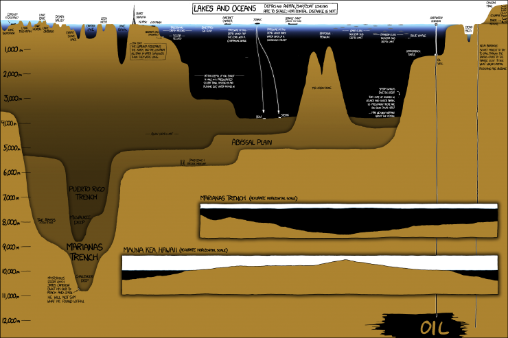
Randall Munroe www.XKCD.com

Our focus on day three was the Astoria canyon – a submarine feature just off the Oregon and Washington coast. Our first oceanographic station was 40 miles offshore, and 1300 meters deep, while the second was 20 miles offshore and only 170 meters deep.  See the handy infographic below to get a perspective on what those depths mean in the grand scheme of things.  From an oceanographic perspective, the neatest finding of the day was our ability to detect the freshwater plume coming from the Columbia River at both those stations despite their distance from each other, and from shore! Water density is one of the key characteristics that oceanographers use to track parcels of water as they travel through the ocean conveyor belt. Certain bodies of water (like the Mediterranean Sea, or the Atlantic or Pacific Oceans) have distinct properties that allow us to recognize them easily. In this case, it was very exciting to “sea” the two-layer system we had gotten used to observing overlain with a freshwater lens of much lower salinity, higher temperature, and lower density. This combination of freshwater, saltwater, and intriguing bathymetric features can lead to interesting foraging opportunities for marine megafauna – so, what did we find out there?

Click through link for better resolution: Randall Munroe www.XKCD.com/1040/large

Morning conditions were almost perfect for marine mammal observations – glassy calm with low swell, good, high, cloud cover to minimize glare and allow us to catch the barest hint of a blow….. it should come as no surprise then, that the first sightings of the day were seabirds and tuna!

I didn't catch any photos of the Tuna, so here's some mola mola we spotted. photo credit: Florence Sullivan
I didn’t catch any photos of the tuna, so here’s some sunfish we spotted. photo credit: Florence Sullivan

One of the best things about being at sea is the ability to look out at the horizon and have nothing but water staring back at you. It really drives home all the old seafaring superstitions about sailing off the edge of the world.  This close to shore, and in such productive waters, it is rare to find yourself truly alone, so when we spot a fishing trawler, there’s already a space to note it in the data log.  Ships at sea often have “follower” birds – avians attracted by easy meals as food scraps are dumped overboard. Fishing boats usually attract a lot of birds as fish bycatch and processing leftovers are flushed from the deck.  The birders groan, because identification and counts of individuals get more and more complicated as we approach other vessels.  The most thrilling bird sighting of the day for me were the flocks of a couple hundred fork-tailed storm petrels.

Fork-tailed storm petrels
Fork-tailed storm petrels. photo credit: Florence Sullivan

I find it remarkable that such small birds are capable of spending 80% of their life on the open ocean, returning to land only to mate and raise a chick. Their nesting strategy is pretty fascinating too – in bad foraging years, the chick is capable of surviving for several days without food by going into a state of torpor. (This slows metabolism and reduces growth until an adult returns.)

Just because the bird observers were starting to feel slightly overwhelmed, doesn’t mean that the marine mammal observers stopped their own survey.  The effort soon paid off with shouts of “Wait! What are those splashes over there?!” That’s the signal for everyone to get their binoculars up, start counting individuals, and making note of identifying features like color, shape of dorsal fin, and swimming style so that we can make an accurate species ID. The first sighting, though common in the area, was a new species for me – Pacific white sided dolphins!

Pacific white sided dolphin
A Pacific white sided dolphin leaps into view. photo credit: Florence Sullivan. Taken under NMFS permit 16111 John Calambokidis

A pod of thirty or so came to ride our bow wake for a bit, which was a real treat. But wait, it got better! Shortly afterward, we spotted more activity off the starboard bow.  It was confusing at first because we could clearly see a lot of splashes indicating many individuals, but no one had glimpsed any fins to help us figure out the species. As the pod got closer, Leigh shouted “Lissodelphis! They’re lissodelphis!”  We couldn’t see any dorsal fins, because northern right whale dolphins haven’t got one! Then the fly bridge became absolute madness as we all attempted to count how many individuals were in the pod, as well as take pictures for photo ID. It got even more complicated when some more pacific white sided dolphins showed up to join in the bow-riding fun.

Northern right whale dolphins are hard to spot! photo credit: Florence Sullivan Taken under NMFS permit 16111 John Calambokidis

All told, our best estimates counted about 200 individuals around us in that moment. The dolphins tired of us soon, and things continued to calm down as we moved further away from the fishing vessels.  We had a final encounter with an enthusiastic young humpback who was breaching and tail-slapping all over the place before ending our survey and heading towards Astoria to make our dock time.

Humpback whale breach
Humpback whale breach. photo credit: Florence Sullivan. Taken under NMFS permit 16111 John Calambokidis

As a Washington native who has always been interested in a maritime career, I grew up on stories of The Graveyard of the Pacific, and how difficult the crossing of the Columbia River Bar can be. Many harbors have dedicated captains to guide large ships into the port docks.  Did you know the same is true of the Columbia River Bar?  Conditions change so rapidly here, the shifting sands of the river mouth make it necessary for large ships to receive a local guest pilot (often via helicopter) to guide them across.  The National Motor Lifeboat School trains its students at the mouth of the river because it provides some of “the harshest maritime weather conditions in the world”.  Suffice it to say, not only was I thrilled to be able to detect the Columbia River plume in our CTD profile, I was also supremely excited to finally sail across the bar.  While a tiny part of me had hoped for a slightly more arduous crossing (to live up to all the stories you know), I am happy to report that we had glorious, calm, sunny conditions, which allowed us all to thoroughly enjoy the view from the fly bridge.

Cape Disappointment Lighthouse at the Columbia River Bar.

Finally, we arrived in Astoria, loaded all our gear into the ship’s RHIB (Ridged Hulled Inflatable Boat), lowered it into the river, descended the rope ladder, got settled, and motored into port. We waved goodbye to the R/V Oceanus, and hope to conduct another STEM cruise aboard her again soon.

Now if the ground would stop rolling, that would be just swell.

Last but not least, here are the videos we promised you in Oceanus Day Two – the first video shows the humpback lunge feeding behavior, while the second shows tail slapping. Follow our youtube channel for more cool videos!


Oceanus Day Two: All the Albatrosses

By Amanda Holdman and Florence Sullivan

Today got off to a bright and early start. As soon as daylight permitted, we had spotters out on duty looking for more marine mammals. We began to survey at the north end of Heceta bank, where we again encountered many humpback whales lunge feeding. We broke transect, and got some great video footage of a pair them – so check our youtube channel next week – we’ll upload the video as soon as we get back to better internet (dial up takes some getting used to again – the whales don’t know about highspeed yet).

Humpbacks lunge feeding at surface. photo credit: Leigh Torres. Taken under NMFS permit 16111 John Calambokidis.

After working with the humpbacks to capture photo-id data for about an hour, we turned south, and ran parallel to Heceta bank until we reached the southern edge. Along the way, we counted 30 humpbacks, and many California gulls, marbled murrelets, pink footed shearwaters, and sooty shearwaters.

After lunch, we conducted a CTD cast to see how conditions might be different between the southern and northern edges of the bank. Surface temperatures increased from 12.09C to 13.2C while bottom temperatures decreased from 8.7C to 7.8C.  The northern station was a textbook perfect two layer system. It had a well mixed surface layer with a steep pycnocline separating it from the colder, saltier, denser, bottom layer. The southern station still had two layers, but the pycnocline (the depth where a rapid change in density occurs, which delineates the edges of water masses) was not as steep. We are interested in these discreet measurements of ocean conditions because areas of high primary productivity (the green chlorophyll-a line) are often re-occurring hot spots of food for many levels of the food chain. Since we can’t phone the whales and ask them where to meet up, we use clues like these to anticipate the best place to start looking.

Readout of the CTD cast. The left plot has temperature in blue, and salinity in green. The right plot has density in black, chlorophyll-a in green, and oxygen in blue. observe how different variables change with depth!
Readout of the CTD cast. The left plot has temperature in blue, and salinity in green. The right plot has density in black, chlorophyll-a in green, and oxygen in blue. observe how different variables change with depth (on the y-axes)!

We next turned west to transect the continental shelf break. Here, we were hoping to observe changes in species composition as waters got deeper, and habitat changed.  The shelf break is often known as an area of upwelling and increased primary productivity, which can lead to concentrations of marine predators taking advantage of aggregations of prey. As we moved further offshore, everyone was hoping for some sperm whales, or maybe some oceanic dolphin species, and if we’re really lucky, maybe a beaked whale or two.

Black footed Albatross with immature gulls. photo credit: Leigh Torres

Today our students learned the lesson of how difficult marine mammal observation can be when our target species spend the majority of their lives underwater – where we can’t see them. While there were a couple of hours of mammal empty water in there, observers were kept busy identifying long tailed- jaegers, cassin’s auklets, murrelets, petrels, shearwaters, fulmars, and so many black-footed albatrosses, that they almost became “normal”.  That being said, we did spot a fin whale, a few groups of Dall’s porpoise, and three pacific-white-sided dolphins.  Unexpectedly, we also saw an unidentified shark, and several sunfish (mola mola)!

Humpback whale profile. photo credit: Amanda Holdman. Taken under NMFS permit 16111 John Calambokidis.
Humpback whale profile – notice the hump before the dorsal fin. photo credit: Amanda Holdman. Taken under NMFS permit 16111 John Calambokidis.
Fin Whale profile. photo credit: Amanda Holdman. Taken under NMFS permit 16111 John Calambokidis.
Fin Whale profile – notice how long the back is before the fin, and how pointed the dorsal fin is compared to the humpback. photo credit: Amanda Holdman. Taken under NMFS permit 16111 John Calambokidis.

Last but not least, we engaged in a long standing oceanographic tradition, which is to draw on Styrofoam cups, and send them down to Davy Jone’s Locker attached to the CTD.  When you bring them back up, the pressure has caused them to shrink to a fraction of their original size, which is an excellent demonstration of the crushing power of pressure (and why its harder to build a submarine than a rocket).

Shrunken cups! The first row have been sent down to 1400m, while the back row are still full size!

Now, we are steaming north toward Astoria Canyon, where we hope to make some more sightings in the morning. Stand by for news from our final day at sea.

Fin Whale. photo credit Amanda Holdman. Taken under NMFS permit 16111 John Calambokidis.
Dahl's Porpoise. photo credit: Florence Sullivan. Taken under NMFS permit 16111 John Calambokidis.
Dahl’s Porpoise. photo credit: Florence Sullivan. Taken under NMFS permit 16111 John Calambokidis.