Whispers of fear

By Leila S. Lemos, Ph.D. candidate in Wildlife Sciences, Fisheries and Wildlife Department


What did you do when playing hide-and-seek? You would try your best not to move or make any noise that would cause the seeker to hear you and find you, right? So, I always associated the prey-predator relationship to a hide-and-seek game, where prey hide, and predators seek. Thus, if you are the prey in this food chain game you should try to hide and not make any noise.

I read an article last week that made me think of this relationship again. The article, “Right whale moms ‘whisper’ to their babies so sharks won’t hear”, announced the study findings from Susan E. Parks and collaborators (2019), which really called my attention.

To give some context, North Atlantic Right Whales (NARWs; Eubalaena glacialis; Fig. 1) occur primarily in northern Atlantic coastal waters or close to the continental shelf (Fig. 2), yet their presence in deep waters are also known (NOAA 2019).

Figure 1: A mother-calf pair of North Atlantic right whales.
Source: Dana Cusano, Syracuse University (NMFS Permit #775-1875); retrieved from Kooser 2019.
Figure 2: North Atlantic right whale distribution.
Source: NOAA 2019.

The species is critically endangered and estimated at less than 500 individuals (IUCN 2007, Pace et al. 2017). Unlike several other whale populations, NARWs have not rebounded from intense whaling, and its population has begun to decrease since 2010 (Thomas et al. 2016, Pace et al. 2017). NARWs’ biggest threats are associated with anthropogenic activities, including entanglement in fishing lines and collisions with vessels (Fig. 3).

Figure 3: North Atlantic right whales’ biggest threats: (A) entanglement in fishing gear, and (B) vessel collision.
Source (A): Peter Duley (NOAA), retrieved from Guy 2017; (B) Williams 2019.

Other than anthropogenic impacts, NARWs also face natural threats like predation. There are reports on newborn and young right whale calf’s predation by killer whales and large sharks (Taylor et al. 2013, Parks et al. 2019; Fig. 4).

Figure 4: Mother carries her calf carcass presenting two semicircular shark bite marks on its flank.
Source: Taylor et al. 2013.

Whales communicate by acoustic signals that can efficiently propagate underwater and be detected by listening predators (Parks et al. 2019). It is possible that mother-calf pairs may use cryptic behaviors to avoid the attention of predators by shifting their communication patterns, leading to a hypothesis that they produce low-amplitude calls and lower call rates (Tyack 2000; Fig. 5). These two behavioral modifications have been previously observed in mother-calf pairs of humpback whales (Megaptera novaeangliae; Videsen et al. 2017) and southern right whales (Eubalaena australis; Nielsen et al. 2019).

Figure 5: Spectrogram and waveform of a single pulse (low amplitude) and an upcall (high amplitude) produced by a right whale. A louder and longer signal (high-amplitude call) is potentially easier to detect by predators.
Source: Parks et al. 2019.

In order to determine if NARWs exhibited the same behavior, Parks and collaborators (2019) tagged lactating and non-lactating females, and a pregnant female that later was tagged again with her calf, to collect acoustic, movement and orientation data. Their results indicate that lactating females use a significantly higher low-amplitude call rate (mean ± standard deviation: 7.13 ± 2.0 calls) when compared to high-amplitude calls (0.88 ± 0.70 calls). In contrast, non-lactating females exhibited higher rates of high-amplitude calls (3.21 ± 2.29 calls) and lower rates of calls of low-amplitude (0.80 ± 1.15 calls).

Even though their sample size was small (n = 16), the authors had more lactating females sampled than the other demographic groups (n = 11), and their results provide evidence that right whale mother-calf pairs exhibit a shift in their repertoire: Mother-calf pairs reduce high-amplitude calls as compared with other demographic groups in the same habitat (Fig. 6).
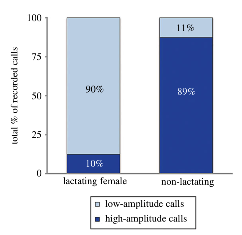
Figure 6: Proportion of high and low-amplitude calls by both lactating and non-lactating female right whales on the calving grounds located in the southeastern United States.
Source: Parks et al. 2019.

According to Dr. Parks, these low-amplitude sounds are analogous with human whispers (Kooser, 2019). This ‘whispering’ is a behavioral adaptation that allows communication between mother and calf without drawing the attention of undesirable predators.

Such an adaptation may seem obvious to us when we think back of our hide-and-seek game, but documentation of little details of the cryptic lives of whales is unique and fascinating.  We still don’t know so much about the lives of whales, so determining adaptations, behavioral and physiological changes, and other simple features like “whispering” are crucial for us to better understand the ‘whale world’ and be able to enhance conservation efforts.


References

Guy 2017. North Atlantic right whales are going extinct. A new invention could save them. Retrieved from https://oceana.org/blog/north-atlantic-right-whales-are-going-extinct-new-invention-could-save-them. Accessed on 17 Oct 2019.

IUCN 2007. North Atlantic Right Whale. Retrieved from https://www.iucnredlist.org/species/41712/10541234. Accessed on 16 Oct 2019.

Kooser A. 2019. Right whale moms ‘whisper’ to their babies so sharks won’t hear. CNET. Retrieved from https://www.cnet.com/news/right-whale-moms-whisper-to-their-babies-for-an-important-reason/?fbclid=IwAR0JcKgYPII4a-BTjm7VPtOfjyVIb63F-SLAjyZZ2KXA6GvYJozfazcfHjA. Accessed on 16 Oct 2019.

Nielsen ML, Bejder L, Videsen SK, Christiansen F, Madsen PT. 2019. Acoustic crypsis in southern right whale mother-calf pairs: infrequent, low-output calls to avoid predation? J. Exp. Biol. 222:jeb190728.

NOAA 2019. North Atlantic Right Whale. NOAA Fisheries. Retrieved from https://www.fisheries.noaa.gov/species/north-atlantic-right-whale. Accessed on 16 Oct 2019.

Pace III RM, Corkeron PJ, Kraus SD. 2017. State-space mark-recapture estimates reveal a recent decline in abundance of North Atlantic right whales. Ecology and Evolution 7:8730–8741.

Parks SE, Cusano DA, Van Parijs SM, Nowacek DP. 2019. Acoustic crypsis in communication by North Atlantic right whale mother-calf pairs on the calving grounds. Biology Letters 15:20190485.

Taylor JKD, Mandelman JW, McLellan WA, Moore MJ, Skomal GB, Rotstein DS, Kraus SD. 2013. Shark predation on North Atlantic right whales (Eubalaena glacialis) in the southeastern United States calving ground. Marine Mammal Science 29(1): 204–212.

Thomas PO, Reeves RR, Brownell RL. 2016. Status of the world baleen whales. Marine Mammal Science 32:682–734.

Tyack PL. 2000. Functional aspects of cetacean communication. In Cetacean societies: field studies of dolphins and whales (eds J Mann, RC Connor, PL Tyack, H Whitehead), pp. 270–307. Chicago, IL:University of Chicago Press.

Videsen SKA, Bejder L, Johnson M, Madsen PT. 2017. High suckling rates and acoustic crypsis of humpback whale neonates maximise potential for mother-calf energy transfer. Funct. Ecol. 31:1561–1573.

Williams 2019. Right whale grandmother known as Punctuation killed by ship strike. Retrieved from https://www.cbc.ca/news/canada/nova-scotia/north-atlantic-right-whale-punctuation-died-after-ship-strike-1.5191987. Accessed on 17 Oct 2019.
Burning it down

By Leila S. Lemos, PhD Candidate in Wildlife Sciences, Fisheries and Wildlife Department, OSU

As you might know, the GEMM Lab (Geospatial Ecology of MARINE Megafauna Laboratory) researches the marine environment, but today I am going to leave the marine ecosystem aside and I will discuss the Amazon biome. As a Brazilian, I cannot think of anything else to talk about this week than the terrifying fire that is burning down the Amazon forest in this exact minute.

For some context, the Amazon biome is known as the biome with the highest biodiversity in the world (ICMBio, 2019). It is the largest biome in Brazil, accounting for ~49% of the Brazilian territory. This biome houses the biggest tropical forest and hydrographic basin in the world. The Amazon forest also extends through eight other countries: Bolivia, Colombia, Ecuador, Guiana, French Guiana, Peru, Suriname and Venezuela. To date, at least 40,000 plant species, 427 mammals, 1,300 birds, 378 reptiles, more than 400 amphibians, around 3,000 freshwater fishes, and around 100,000 invertebrate species have been described by scientists in the Amazon, comprising more than 1/3 of all fauna species on the planet (Da Silva et al. 2005, Lewinsohn and Prado 2005). And, these numbers are likely to increase; According to Patterson (2000), one new genus and eight new species of Neotropical mammals are discovered each year in the region.

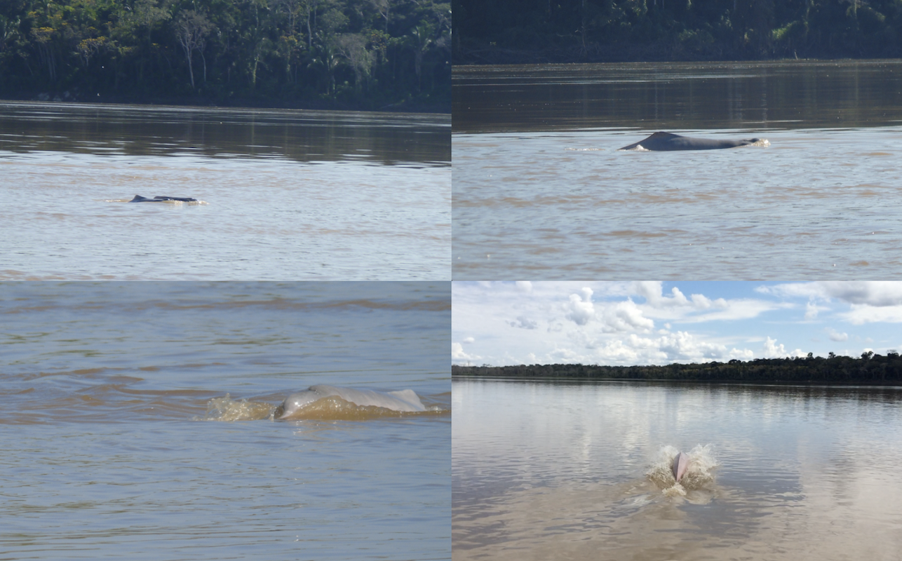
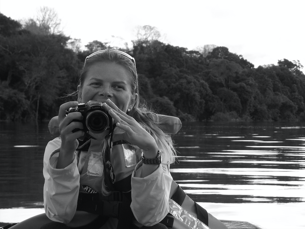
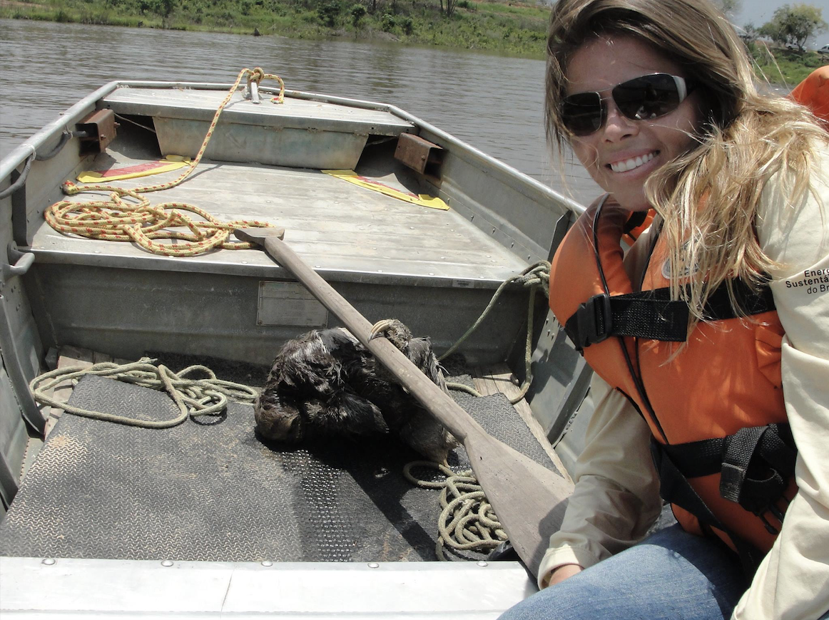
I feel very connected to the Amazon as I worked as an environmental consultant and field coordinator in 2014 and 2015 (Figs. 1 and 2) along the Madeira river (or “Wood” river) in Rondonia, Brazil (Fig. 3). I monitored Amazon river dolphins (Inia geoffrensis; Fig. 4), a species considered endangered by the IUCN Red List in 2018 (Da Silva et al. 2018). The Madeira river originates in Bolivia and flows into the great Amazon river, comprising one of its main tributaries (Fig. 3).

Figure 1: Me, working along the Madeira river, Rondonia, Brazil, in 2015.
Source: Laura K. Honda, 2015.
Figure 2: Me, helping to rescue a sloth from the Madeira river, Rondonia, Brazil, in 2014.
Source: Roberta Lanziani, 2014.
Figure 3: The Amazon hydrographic basin, with the Madeira river highlighted.
Source: Wikipedia, 2019.
Figure 4: Amazon river dolphins (I. geoffrensis) along the Madeira river, Rondonia, Brazil.
Source: Leila S. Lemos, 2014; 2015.

Here is also a video where you can see some Amazon river dolphins along the Madeira river:

Source: Leila S. Lemos, 2014; 2015.

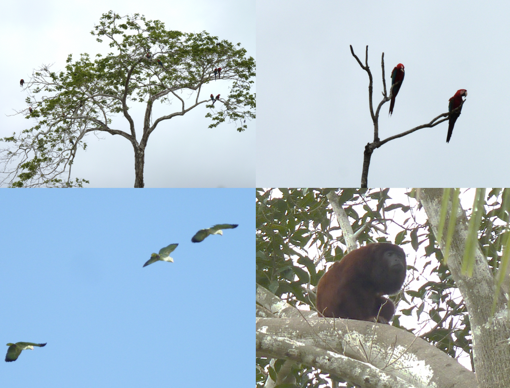
In addition to the dolphins, I witnessed the presence of many other fauna specimens like birds (including macaws and parrots), monkeys, alligators and sloths (Fig. 5). The biodiversity of the Amazon is unquestionable.

Figure 5: Macaws (Ara chloropterus), parrots (Amazona sp.) and the Guariba monkey or brown howler (Allouatta guariba) along the Madeira river, Rondonia, Brazil.
Source: Leila S. Lemos

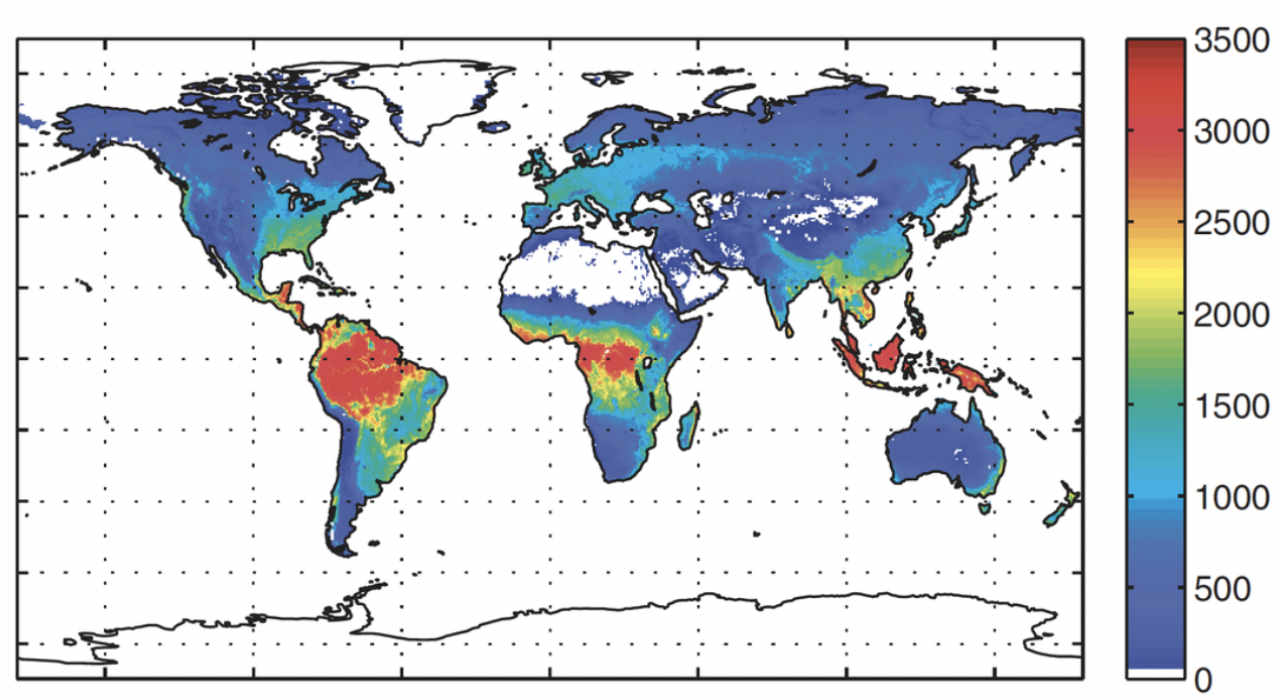
Other than its great biodiversity, the Amazon is known as the “lungs of the Earth”, which is an erroneous statement since plants consume as much oxygen as they produce (Malhi et al. 2008, Malhi 2019). But still, the Amazon forest is responsible for 16% of the oxygen produced by photosynthesis on land and 9% of the oxygen on the global scale (Fig. 6). This seems a small percentage, but it is still substantial, especially because the plants use carbon dioxide during photosynthesis, which accounts for a 10% reduction of atmospheric carbon dioxide. Thus, imagine if there was no Amazon rainforest. The rise in carbon dioxide would be enormous and have serious implications on the global climate, surpassing safe temperature boundaries for many regions.

Figure 6: Total photosynthesis of each major land biome. This value is multiplied by 2.67 to convert to total oxygen production. Hence total oxygen production by photosynthesis on land is around 330 Pg of oxygen per year. The Amazon (just under half of the tropical forests) is around 16% of this, around 54 Pg of oxygen per year.
Source: Malhi 2019.

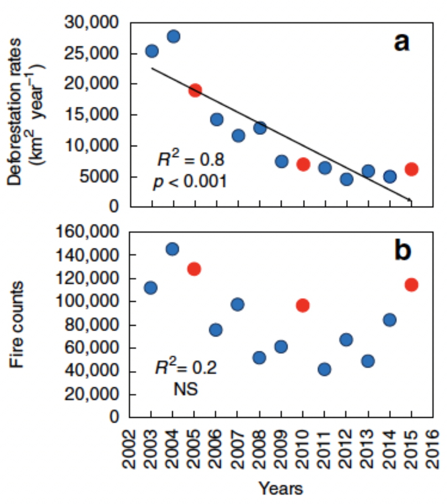
Unfortunately, this scenario is not really far from us. Even though deforestation indices have fallen in the last 15 years, fire incidence associated with droughts and carbon emissions have increased (Aragão et al. 2018; Fig. 7).

Figure 7: Linear trends (2003–2015) of annual (a) deforestation rates, and (b) active fires counts in the Brazilian Amazon. Red circles indicate the analyzed drought years by Aragão et al. (2018).
Source: Aragão et al. 2018.

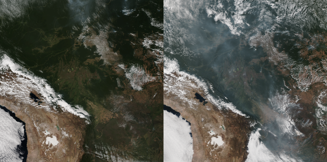
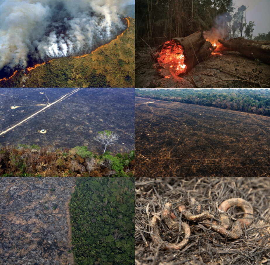
Since August 2019, the Amazon forest has experienced extreme fire outbreaks (Figs. 8 and 9). Around 80,000 fires occurred only in 2019. Despite 2019 not being an extreme drought year, the period of January-August 2019 is characterized by an ~80% increase in fires compared to the previous year (Wagner and Hayes 2019). The intensification of the fires has been linked to the Brazilian President’s incentive to “open the rainforest to development”. Leaving politics aside, the truth is that the majority of these fires have been set by loggers and ranchers seeking to clear land to expand the agro-cattle area (Yeung 2019).

Figure 8: The Amazon in July 28: just clouds; and in August 22: choked with smoke.
Source: NOAA, in: Wagner and Hayes, 2019.
Figure 9: Images showing some of the destruction caused by the fires in the Amazon region in 2019.
Source: Buzz Feed News 2019, Sea Mashable 2019.

Here you can see some videos showing the extension of the problem:

Video 1 – by NBC News:

Video 2 – a drone footage by The Guardian:

I consider myself lucky for the opportunity to have worked in the Amazon rainforest before these chaotic fires have destroyed so much biodiversity. The Amazon is a crucial home for countless animal and plant species, and to ~900,000 indigenous individuals that live in the region. They are all at risk of losing their homes and lives. We are all at risk of global warming.

References

Aragão LEOC, Anderson LO, Fonseca MG, Rosan TM, Vedovato LB, Wagner FH, Silva CVJ, Silva Junior CHL, Arai E, Aguiar AP, Barlow J, Berenguer E, Deeter MN, Domingues LG, Gatti L, Gloor M, Malhi Y, Marengo JA, Miller JB, Phillips OL, and Saatchi S. 2018. 21stCentury drought-related fires counteract the decline of Amazon deforestation carbon emissions. Nature Communications 9(536):1-12.

Buzz Feed News. 2019. These Heartbreaking Photos Show The Devastation Of The Amazon Fires. Retrieved 1 September 2019 from https://www.buzzfeednews.com/article/gabrielsanchez/photos-trending-devastation-amazon-wildfire

Da Silva JMC, Rylands AB, and Da Fonseca GAB. 2005. The Fate of the Amazonian Areas of Endemism. Conservation Biology 19(3):689-694.

Da Silva V, Trujillo F, Martin A, Zerbini AN, Crespo E, Aliaga-Rossel E, and Reeves R. 2018. Inia geoffrensis. The IUCN Red List of Threatened Species 2018: e.T10831A50358152. http://dx.doi.org/10.2305/IUCN.UK.2018-2.RLTS.T10831A50358152.en. Downloaded on 27 August 2019.

ICMBio. 2019. Amazônia. Retrieved 26 August 2019 from http://www.icmbio.gov.br/portal/unidades deconservacao/biomas-brasileiros/amazonia

Lewinsohn TM, and Prado PI. 2005. How Many Species Are There in Brazil? Conservation Biology 19(3):619.

Malhi Y. 2019. does the amazon provide 20% of our oxygen? Travels in ecosystem science. Retrieved 29 August 2019 from http://www.yadvindermalhi.org/blog/does-the-amazon-provide-20-of-our-oxygen

Malhi Y., Roberts JT, Betts RA, Killeen TJ, Li W, Nobre CA. 2008. Climate Change, Deforestation, and the Fate of the Amazon. Science 319:169-172.

Patterson BD. 2000. Patterns and trends in the discovery of new Neotropical mammals. Diversity and Distributions, 6, 145-151.

Sea Mashable. 2019. The Amazon forest is burning to the ground. Here’s how it happened and what you can do to help. Retrieved 1 September 2019 from https://sea.mashable.com/culture/5813/the-amazon-forest-is-burning-to-the-ground-heres-how-it-happened-and-what-you-can-do-to-help

Wagner M, and Hayes M. 2019. Wildfires rage in the Amazon. CNN. Retrieved 26 August 2019 from https://www.cnn.com/americas/live-news/amazon-wildfire-august-2019/index.html

Wikipedia. 2019. Madeira river. Retrieved 29 August 2019 from https://en.wikipedia.org/wiki/Madeira_River

Yeung J. 2019. Blame humans for starting the Amazon fires, environmentalists say. CNN. Retrieved 26 August 2019 from https://www.cnn.com/2019/08/22/americas/amazon-fires-humans-intl-hnk-trnd/index.html

What areas on the landscape do you value? Application of Human Ecology Mapping in Oregon

By: Jackie Delie, M.S. Student, OSU Department of Fisheries and Wildlife, Human Dimensions Lab (Dr. Leigh Torres, committee member providing spatial analysis guidance)


Mapping sociocultural data for ecosystem-based planning, like people’s values or cultural land use practices, has gained importance in conservation science, as reflected in the use of terms such as social-ecological systems (Lischka et al. 2018). The emergence of the geospatial revolution – where data have a location associated with it – has changed how scientists analyze, visualize, and scale their perceptions of landscapes and species. However, there is a limited collection of spatial sociocultural data compared to biophysical data.

To address the restricted spatial sociocultural data available, scientists (such as social scientists), community leaders, and indigenous groups have used various mapping methods for decision-making in natural resources planning to capture people’s uses, values, and interaction between people and landscapes. Some mapping methods are termed community values mapping (Raymond et al. 2009), landscape values mapping (Besser et al. 2014), public participation GIS (Brown & Reed 2009), and social values mapping (Sherrouse et al. 2011). Mclain et al. (2013) applies the umbrella term Human Ecology Mapping (HEM) to refer to all these mapping approaches that span across academic disciplines and sub-disciplines. HEM focuses on understanding human-environmental interactions, intending to gather spatial data on aspects of human ecology that can potentially be important to ecosystem-based management and planning. As an early career scientist, I embraced the opportunity to incorporate a HEM approach, more specifically the mapping of landscape values, into my thesis.

My research explores the human-black bear relationship in Oregon. The American black bear (Ursus americanus) is one species identified by the Oregon Department of Fish and Wildlife with a stable or increasing population (25,000 to 35,000 individuals) where many human-black bear interactions occur (ODFW 2012). One component of my research incorporates understanding how recreationists use the landscape and the values they associate with different places. For 18 days in the summer of 2018, I was at various trailheads throughout Oregon, approaching people to request their interest in taking my survey (Image 1 & 2). The consenting participants were asked to identify on the digital map of Oregon the primary places they use or visit on the landscape. Participants had the option to draw a point, line, or polygon to identify up to three places within the state (Image 3). Then, participants were asked to choose the type of activity they prefer at each primary location from a list of 17 recreational activities (e.g., hiking, hunting, fishing, camping, etc.). Finally, they were asked to select one primary value they associate with each identified place from a list of five standardized landscape values (Brown & Reed 2009; Besser et al. 2014). The most important values for my study are aesthetic, economic, intrinsic, subsistence, and social. An example of an aesthetic value statement: “I value this area for its scenic qualities”.

Now that my data is collected, I am creating GIS layers of the various ways recreationists uses the landscape, and the values they assign to those places, showing the distribution of aggregated uses (Image 4) and their relationship to known human-black bear interaction areas. The approach I employed to collect social-spatial data is just one strategy out of many, and it is recognized that maps are never fully objective representations of reality. However, mapping landscape values is a useful tool for identifying and visualizing human-environment relations. The geographically referenced data can be used to map areas of high value (density) or associated with different types of values (diversity). Further, these maps can be overlaid with other biophysical and land use layers to help land managers understand the variety of landscape values and activities.


Southern Oregon in August 2018. Lots of fires in the area during this time and that had an impact on where I could collect data as certain forest areas were closed to the public.


Me collecting data at Upper Table Rock Trailhead in Southern Oregon


Use of an Ipad and the software Mappt to collect socio-spatial data while at trailheads in Oregon. Participants used the digital map to identify up to three places they primarily use the landscape.


Preliminary map displaying all the areas of preferred landscape use (orange) marked by survey participants.


References:

Besser, D., McLain, R., Cerveny, L., Biedenweg, K. and Banis, D. 2014. Environmental Reviews and Case Studies: Mapping Landscape Values: Issues, Challenges and Lessons Learned from Field Work on the Olympic Peninsula, Washington, Environmental Practice, 16(2): 138–150.

Brown, G., and Reed, P. 2009. Public Participation GIS: A New Method for Use in National Forest Planning. Forest Science, 55(2): 162-182.

Lischka, S., Teel, T., Johnson, H., Reed, S., Breck, S., Don Carlos, A., Crooks, K. 2018. A conceptual model for the integration of social and ecological information to understand human-wildlife interactions. Biological Conservation 225: 80-87.

McLain, R., Poe, M., Biedenweg, K., Cerveny, L., Besser, D., and Blahna, D. 2013. Making sense of human ecology mapping: An overview of approaches to integrating socio-spatial data into environmental planning. Human Ecology, 41(1).

Oregon Department of Fish and Wildlife (ODFW). 2012. Oregon Black Bear Management Plan.

Raymond, M., Bryan, A., MacDonald, H., Cast, A., Strathearn, S., Grandgirard, A., and Kalivas, T. 2009. Mapping Community Values for Natural Capital and Ecosystem Services. Ecological Economics 68: 1301–1315.

Sherrouse, B. C., Clement, J. M., and Semmens, D. J. 2011. A GIS Application for Assessing, Mapping, and Quantifying the Social Values of Ecosystem Services. Applied Geography, 31: 748–760.

Current gray whale die-off: a concern or simply the circle of life?

By Leila Lemos, PhD Candidate in Wildlife Sciences, Fisheries and Wildlife Department / OSU

Examination of a dead gray whale found in Pacifica, California, in May 2019.
Source: CNN 2019.


The avalanche of news on gray whale deaths this year is everywhere. And because my PhD thesis focuses on gray whale health, I’ve been asked multiple times now why this is happening. So, I thought it was a current and important theme to explore in our blog. The first question that comes to (my) mind is: is this a sad and unusual event for the gray whales that raises concern, or is this die-off event expected and simply part of the circle of life?

At least 64 gray whales have washed-up on the West Coast of the US this year, including the states of California, Oregon and Washington. According to John Calambokidis, biologist and founder of the Cascadia Research Collective, the washed-up whales had one thing in common: all were in poor body condition, potentially due to starvation (Calambokidis in: Paris 2019). Other than looking skinny, some of the whale carcasses also presented injuries, apparently caused by ship strikes (CNN 2019).

Cascadia Research Collective examining a dead gray whale in 9 May 2019, washed up in Washington state. Cause of death was not immediately apparent but appeared consistent with nutritional stress.
Source: Cascadia Research Collective 2019.

To give some context, gray whales migrate long distances while they fast for long periods. They are known for performing the longest migration ever seen for a mammal, as they travel up to 20,000 km roundtrip every year from their breeding grounds in Baja California, Mexico, to their feeding grounds in the Bering and Chukchi seas (Calambokidis et al. 2002, Jones and Swartz 2002, Sumich 2014). Thus, a successful feeding season is critical for energy replenishment to recover from the previous migration and fasting periods, and for energy storage to support their metabolic needsduring the migration and fasting periods that follow. An unsuccessful feeding season could likely result in poor body condition, affecting individual performance in the following seasons, a phenomenon known as the carry-over effect(Harrison et al., 2011).

In addition, environmental change, such as climate variations, might impact shifts in prey availability and thus intensify energetic demands on the whales as they need to search harder and longer for food. These whales already fast for months and spend large energy reserves supporting their migrations. When they arrive at their feeding grounds, they need to start feeding. If they don’t have access to predictable food sources, their fitness is affected and they become more vulnerable to anthropogenic threats, including ship strikes, entanglement in fishery gear, and contamination.

For the past three years, I have been using drone-based photogrammetry to assess gray whale body condition along the Oregon coast, as part of my PhD project. Coincident to this current die-off event, I have observed that these whales presented good body condition in 2016, but in the past two years their condition has worsened. But these Oregon whales are feeding on different prey in different areas than the rest of the ENP that heads up to the Bering Sea to feed. So, are all gray whales suffering from the same broad scale environmental impacts? I am currently looking into environmental remote sensing data such as sea surface temperature, chlorophyll-a and upwelling index to explore associations between body condition and environmental anomalies that could be associated.

Trying to answer the question I previously mentioned “is this event worrisome or natural?”, I would estimate that this die-off is mostly due to natural patterns, mainly as a consequence of ecological patterns. This Eastern North Pacific (ENP) gray whale population is now estimated at 27,000 individuals (Calambokidis in: Paris 2019) and it has been suggested that this population is currently at its carrying capacity(K), which is estimated to be between 19,830 and 28,470 individuals (Wade and Perryman, 2002). Prey availability on their primary foraging grounds in the Bering Sea may simply not be enough to sustain this whole population.

The plot below illustrates a population in exponential growth over the years. The population reaches a point (K) that the system can no longer support. Therefore, the population declines and then fluctuates around this K point. This pattern and cycle can result in die-off events like the one we are currently witnessing with the ENP gray whale population.

Population at a carrying capacity (K)
Source: Conservation of change 2019.


According to the American biologist Paul Ehrlich: “the idea that we can just keep growing forever on a finite planet is totally imbecilic”. Resources are finite, and so are populations. We should expect die-off events like this.

Right now, we are early on the 2019 feeding season for these giant migrators. Mortality numbers are likely to increase and might even exceed previous die-off events. The last ENP gray whale die-off event occurred in the 1999-2000 season, when a total of 283 stranded whales in 1999 and 368 in 2000 were found displaying emaciated conditions (Gulland et al. 2005). This last die-off event occurred 20 years ago, and thus in my opinion, it is too soon to raise concerns about the long-term impacts on the ENP gray whale population, unless this event continues over multiple years.


References

Calambokidis, J. et al. 2002. Abundance, range and movements of a feeding aggregation of gray whales (Eschrichtius robustus) from California to southeastern Alaska in 1998. Journal of Cetacean research and Management. 4, 267-276.

Cascadia Research Collective (2019, May 10). Cascadia and other Washington stranding network organizations continue to respond to growing number of dead gray whales along our coast and inside waters. Retrieved from http://www.cascadiaresearch.org/washington-state-stranding-response/cascadia-and-other-washington-stranding-networkorganizations?fbclid=Iw AR1g7zc4EOMWr_wp_x39ertvzpjOnc1zZl7DoMbBcjI1Ic_EbUx2bX8_TBw

Conservation of change (2019, May 31). Limits to Growth: the first law of sustainability. Retrieved from http://www.conservationofchange.org/limits

CNN (2019, May 15). Dead gray whales keep washing ashore in the San Francisco Bay area.Retrieved from https://www.cnn.com/2019/05/15/us/gray-whale-deaths-trnd-sci/index.html

Gulland, F. M. D., H. Pérez-Cortés M., J. Urbán R., L. Rojas-Bracho, G. Ylitalo, J. Weir, S. A. Norman, M. M. Muto, D. J. Rugh, C. Kreuder, and T. Rowles. 2005. Eastern North Pacific gray whale (Eschrichtius robustus) unusual mortality event, 1999-2000. U. S. Dep. Commer., NOAA Tech. Memo. NMFS-AFSC-150, 33 p.

Harrison, X. A., et al., 2011. Carry-over effects as drivers of fitness differences in animals. Journal of Animal Ecology. 80, 4-18.

Jones, M. L., Swartz, S. L., Gray Whale, Eschrichtius robustus. Encyclopedia of Marine Mammals. Academic Press, San Diego, 2002, pp. 524-536.

Paris (2019, May 27). Gray Whales Wash Up On West Coast At Near-Record Levels.Retrieved from https://www.wbur.org/hereandnow/2019/05/27/gray-whales-wash-up-record-levels

Sumich, J. L., 2014. E. robustus: The biology and human history of gray whales. Whale Cove Marine Education.

Wade, P. R., Perryman, W., An assessment of the eastern gray whale population in 2002. IWC, Vol. SC/54/BRG7 Shimonoseki, Japan, 2002, pp. 16.


Knowing me, knowing you: the fate of the toninha, a small dolphin endemic to the Western South Atlantic

By Salvatore Siciliano (1,2)

(1) Laboratório de Enterobactérias, Oswaldo Cruz Institute/Fiocruz, Rio de Janeiro, Brazil
(2) Grupo de Estudos de Mamíferos Marinhos da Região dos Lagos (GEMM-Lagos)


Background information on Pontoporia blainvillei

The toninha (Pontoporia blainvillei) as it is called in Brazil, or franciscana (Fig.01), is a small dolphin endemic to coastal waters of southeastern and southern Brazil, Uruguay and Argentina. It is the only representative of an ancient lineage of odontocetes, once widely spread over the Pacific and Atlantic oceans. Toninhas occur in waters shallower than 30 m and present a discontinuous distribution from Itaúnas, Brazil (18º 25’S) to Golfo San Matías, Argentina (42º 10’S). The species is considered one of the most threatened small cetaceans in South America due to high, and possibly unsustainable, bycatch levels as well as increasing habitat degradation. Incidental catches in fishing gear, especially gillnets and trammel nets, have been reported along most of the species’ range since at least the 1940s. Other rapidly-increasing conservation issues of significant importance for the franciscana in this region include: (1) habitat degradation, (2) underwater noise, (3) chemical pollution from industrial and urban wastewater, (4) activities related to the exploration and production of oil and gas, and (5) vessel traffic. P. blainvilleiis currently listed as ‘Vulnerable’ in the IUCN Red List of Threatened Species and ‘Critically Endangered’ by the Brazilian Government.


Figure 01: A young Pontoporia blainvillei incidentally caught in gillnets set off the northern coast of the state of Rio de Janeiro, Brazil (December 2011).


In order to guide conservation and management actions on a regional basis, the franciscana range was divided into four zones, known as ‘Franciscana Management Areas’ (FMAs), in the early 2000s. FMA I includes Espírito Santo (ES) and northern Rio de Janeiro (RJ), states located in southeastern Brazil. FMA II corresponds to southern RJ, São Paulo (SP), Paraná (PR) and northern Santa Catarina (SC) states, in southeastern and southern Brazil. FMA III encompasses southern SC and Rio Grande do Sul (RS) states, in southern Brazil, in addition to Uruguay. The last FMA, the FMA IV, corresponds to the Argentina coast (Fig.02).

The absence of stranded or incidentally killed animals indicates a gap of approximately 320 km in the franciscana distribution between northern and southern RJ. This gap separates the southern border of FMA I and the northern border of FMA II.


Figure 02: The FMA areas (in blue) in P. blainvillei distribution range, and the gaps (in white) in toninha distribution along the Northern limit of its distribution in Southeastern Brazil.


The toninha is usually very shy and, for this reason, quite difficult to be seen in the wild. More recently, researchers and citizen science projects have succeeded in obtaining very nice pictures of these animals (Fig.03), which are aiding in elucidating the species mysterious behavior, feeding activity and their preferred habitat conditions.

Figure 03: Toninhas in their natural environment along shallow waters off northern São Paulo state, in the summer of 2019. Photo courtesy of Júlio Cardoso, Baleia à Vista Project.


Figure 04: Aerial view of the Restinga de Jurubatiba National Park and its adjacent waters, the main toninha habitat along the northern coast of Rio de Janeiro. Photo by Salvatore Siciliano (November 2017).


Threats to P. blainvillei along the Brazilian coast

Gillnets are still the main cause of toninha mortality along its entire range. They can be used at the surface or placed at the bottom of the ocean to catch fish, but these nets also entangle this small dolphin (Fig.05, Fig.06).

Figure 05: Gillnets, used at the surface or placed at the bottom of the ocean.


Figure 06: Data on gillnet incidental captures of toninhas (Pontoporia blainvillei) along the northern coast of Rio de Janeiro state collected since1988. Note the concentration of records in the Macaé – Quissamã and Cabo de São Thomé areas, adjacent to the Restinga de Jurubatiba National Park. Data on captures come from Prof. Ana Paula M. Di Beneditto/CBB/LCA/UENF.


Toninhas also face other threats along the Brazilian coast, including environmental chemical contamination by metals and persistent organic pollutants. These pollutants are persistent in the aquatic ecosystem and may accumulate and magnify throughout the tropic chain, causing deleterious effects in the aquatic fauna. Recently, an ecotoxicological assessment from our research group (GEMM-Lagos/Fiocruz) verified, for the first time, significant intracellular concentrations of several toxic metals, such as Hg and Pb (Fig.07), in P. blainvillei individuals sampled along the coast of the Rio de Janeiro state.


Figure 07: Novel HPLC-ICP-MS data on intracellular Pb and Hg in P. blainvillei liver (L), muscle (M) and kidney (K) samples from stranded individuals sampled off the coast of Rio de Janeiro, Brazil.


The monitoring of the contaminant levels in toninhas will potentially aid in conservation efforts, as we can identify which metals are of the most concern, because the intracellular presence of toxic metals indicates high bioavailability, probably leading to deleterious effects.


Conservation Efforts

What is a Whale Heritage Site (WHS) and why we are proposing ‘Mosaic Jurubatiba’ as a WHS?

Situated on the Northern coast of Rio de Janeiro state, Brazil, the Jurubatiba region (Fig.04; Fig.08) is now a Candidate Whale Heritage Site (WHS). The area has been termed ‘Mosaic Jurubatiba’ as the candidate site includes not only the Jurubatiba National Park, but also encompasses other significant sites for conservation along the central-north coast that lie across three municipalities: Macaé, Carapebus and Quissamã (Fig.08).

Figure 08: Proposed extension of the Jurubatiba National Park to the adjacent waters, home of a vigorous population of P. blainvillei.
Legend: green – Jurubatiba National Park; red – new terrestrial limit; yellow – new marine limit.


The location provides habitat to a diversity of wildlife. When considering cetaceans, the most regularly seen individuals are the humpback whales, the Guiana dolphins and the toninhas. This is an important site since it is part of the migration route of humpback whales from their breeding and calving grounds, in warm tropical waters, to their feeding grounds, in Antarctica. In addition, this locality is a significant habitat for the toninha, a restricted range species, and the Guiana dolphin, a data deficient species and, therefore, of great concern. The importance of the site becoming a fully accredited WHS is, therefore, evident to further conserve these species and their habitats.

There is a significant amount of active conservation in the Jurubatiba National Park. The Park is the first to exclusively comprise the Restinga ecosystem. Researchers worked alongside authorities and large organizations, such as IBAMA (Brazilian Ministry of Environment and the federal government), to achieve its national park status.

Figure 09: Outreach material produced for the campaign ‘Mosaic Jurubatiba’ to promote education and conservation of the Toninha.


In Quissamã, warning signs were placed along the beaches to alert the population of the importance of the coastal waters as habitat for dolphin species, especially the toninha. This type of cooperation and support of the government and other authorities will aid the candidate site to achieve a full status of WHS.

The long-term goals of the candidate site are to influence the transition away from fishing as a livelihood and to instead embrace the use of responsible tourism to make a living.


For more information on Whale Heritage Sites around the world, visit:

http://worldcetaceanalliance.org/

http://whaleheritagesites.org/candidate-site-jurubatiba/


For more information on the GEMM-Lagos Project:

contact:gemmlagos@gmail.com

visit their Instagram: toninha_cade_vc


Here you can also find a list of some of the Salvatore Siciliano’s publications on Pontoporia blainvillei:

  • Siciliano S, de Moura JF, Tavares DC, Kehrig HA, Hauser-Davis RA, Moreira I, Lavandier R, Lemos LS, EMin-Lima R, Quinete N. 2018. Legacy Contamination in Estuarine Dolphin Species From the South American Coast. In book: Marine Mammal Ecotoxicology. Eds. Fossi MC, Panti C. Publisher: Academic Press.
  • Baptista G, Kehrig HA, Di Beneditto APM, Hauser-Davis RA, Almeida MG, Rezende CE, Siciliano S, de Moura JF and Moreira I. 2016. Mercury, selenium and stable isotopes in four small cetaceans from the Southeastern Brazilian coast: Influence of feeding strategy. Environmental Pollution 218:1298-1307.
  • Frainer G, Siciliano S, Tavares DC. 2016. Franciscana calls for help: the short and long-term effects of Mariana’s disaster on small cetaceans of South-eastern Brazil. International Whaling Commission SC/66b/SM/04. Bled, Slovenia.
  • Lavandier R, Arêas J, Quinete N, de Moura JF, Taniguchi S, Montone RC, Siciliano S, Moreira I. 2015. PCB and PBDE levels in a highly threatened dolphin species from the Southeastern Brazilian coast. Environmental Pollution 208.
  • Lemos LS, de Moura JF, Hauser-Davis RA, de Campos RC, Siciliano S. 2013. Small cetaceans found stranded or accidentally captured in southeastern Brazil: Bioindicators of essential and non-essential trace elements in the environment. Ecotoxicology and Environmental Safety 97:166-175.
  • de Moura JF, Rodrigues ES, Sholl TGC, Siciliano S. 2009. Franciscana dolphin (Pontoporia blainvillei) on the north-east coast of Rio de Janeiro State, Brazil, recorded during a long-term monitoring programme. Marine Biodiversity Records 2:e66.


Photogrammetry Insights

By Leila Lemos, PhD Candidate, Fisheries and Wildlife Department, Oregon State University

After three years of fieldwork and analyzing a large dataset, it is time to finally start compiling the results, create plots and see what the trends are. The first dataset I am analyzing is the photogrammetry data (more on our photogrammetry method here), which so far has been full of unexpected results.

Our first big expectation was to find a noticeable intra-year variation. Gray whales spend their winter in the warm waters of Baja California, Mexico, period while they are fasting. In the spring, they perform a big migration to higher latitudes. Only when they reach their summer feeding grounds, that extends from Northern California to the Bering and Chukchi seas, Alaska, do they start feeding and gaining enough calories to support their migration back to Mexico and subsequent fasting period.


Northeastern gray whale migration route along the NE Pacific Ocean.
Source: https://journeynorth.org/tm/gwhale/annual/map.html


Thus, we expected to see whales arriving along the Oregon coast with a skinny body condition that would gradually improve over the months, during the feeding season. Some exceptions are reasonable, such as a lactating mother or a debilitated individual. However, datasets can be more complex than we expect most of the times, and many variables can influence the results. Our photogrammetry dataset is no different!

In addition, I need to decide what are the best plots to display the results and how to make them. For years now I’ve been hearing about the wonders of R, but I’ve been skeptical about learning a whole new programming/coding language “just to make plots”, as I first thought. I have always used statistical programs such as SPSS or Prism to do my plots and they were so easy to work with. However, there is a lot more we can do in R than “just plots”. Also, it is not just because something seems hard that you won’t even try. We need to expose ourselves sometimes. So, I decided to give it a try (and I am proud of myself I did), and here are some of the results:


Plot 1: Body Area Index (BAI) vs Day of the Year (DOY)


In this plot, we wanted to assess the annual Body Area Index (BAI) trends that describe how skinny (low number) or fat (higher number) a whale is. BAI is a simplified version of the BMI (Body Mass Index) used for humans. If you are interested about this method we have developed at our lab in collaboration with the Aerial Information Systems Laboratory/OSU, you can read more about it in our publication.

The plots above are three versions of the same data displayed in different ways. The first plot on the left shows all the data points by year, with polynomial best fit lines, and the confidence intervals (in gray). There are many overlapping observation points, so for the middle plot I tried to “clean up the plot” by reducing the size of the points and taking out the gray confidence interval range around the lines. In the last plot on the right, I used a linear regression best fit line, instead of polynomial.

We can see a general trend that the BAI was considerably higher in 2016 (red line), when compared to the following years, which makes us question the accuracy of the dataset for that year. In 2016, we also didn’t sample in the month of July, which is causing the 2016 polynomial line to show a sharp decrease in this month (DOY: ~200-230). But it is also interesting to note that the increasing slope of the linear regression line in all three years is very similar, indicating that the whales gained weight at about the same rate in all years.


Plot 2: Body Area Index (BAI) vs Body Condition Score (BCS)


In addition to the photogrammetry method of assessing whale body condition, we have also performed a body condition scoring method for all the photos we have taken in the field (based on the method described by Bradford et al. 2012). Thus, with this second set of plots, we wanted to compare both methods of assessing whale body condition in order to evaluate when the methods agree or not, and which method would be best and in which situation. Our hypothesis was that whales with a ‘fair’ body condition would have a lower BAI than whales with a ‘good’ body condition.

The plots above illustrate two versions of the same data, with data in the left plot grouped by year, and the data in the right plot grouped by month. In general, we see that no whales were observed with a poor body condition in the last analysis months (August to October), with both methods agreeing to this fact. Additionally, there were many whales that still had a fair body condition in August and September, but less whales in the month of October, indicating that most whales gained weight over the foraging seasons and were ready to start their Southbound migration and another fasting period. This result is important information regarding monitoring and conservation issues.

However, the 2016 dataset is still a concern, since the whales appear to have considerable higher body condition (BAI) when compared to other years.


Plot 3:Temporal Body Area Index (BAI) for individual whales


In this last group of plots, we wanted to visualize BAI trends over the season (using day of year – DOY) on the x-axis) for individuals we measured more than once. Here we can see the temporal patterns for the whales “Bit”, “Clouds”, “Pearl”, “Scarback, “Pointy”, and “White Hole”.

We expected to see an overall gradual increase in body condition (BAI) over the seasons, such as what we can observe for Pointy in 2018. However, some whales decreased their condition, such as Bit in 2018. Could this trend be accurate? Furthermore, what about BAI measurements that are different from the trend, such as Scarback in 2017, where the last observation point shows a lower BAI than past observation points? In addition, we still observe a high BAI in 2016 at this individual level, when compared to the other years.

My next step will be to check the whole dataset again and search for inconsistencies. There is something causing these 2016 values to possibly be wrong and I need to find out what it is. The overall quality of the measured photogrammetry images was good and in focus, but other variables could be influencing the quality and accuracy of the measurements.

For instance, when measuring images, I often struggled with glare, water splash, water turbidity, ocean swell, and shadows, as you can see in the photos below. All of these variables caused the borders of the whale body to not be clearly visible/identifiable, which may have caused measurements to be wrong.


Examples of bad conditions for performing photogrammetry: (1) glare and water splash, (2) water turbidity, (3) ocean swell, and (4) a shadow created in one of the sides of the whale body.
Source: GEMM Lab. Taken under NMFS permit 16111 issued to John Calambokidis.


Thus, I will need to check all of these variables to identify the causes for bad measurements and “clean the dataset”. Only after this process will I be able to make these plots again to look at the trends (which will be easy since I already have my R code written!). Then I’ll move on to my next hypothesis that the BAI of individual whales varied by demographics including sex, age and reproductive state.

To carry out robust science that produces results we can trust, we can’t simply collect data, perform a basic analysis, create plots and believe everything we see. Data is often messy, especially when developing new methods like we have done here with drone based photogrammetry and the BAI. So, I need to spend some important time checking my data for accuracy and examining confounding variables that might affect the dataset. Science can be challenging, both when interpreting data or learning a new command language, but it is all worth it in the end when we produce results we know we can trust.


Ocean Jail

a captive marine mammal in an unknown location
Source: Snopes, 2018.


By Leila Lemos

PhD candidate, Fisheries and Wildlife Department, OSU


This past November, headlines were made when a drone captured images of over 100 dolphins confined in Srednyaya Bay, Russia, for commercial reasons.

Figure 01: Location of the “whale jail” in Srednyaya Bay, near Nakhodka, Russia.
Source: Big Think, 2018.


This “whale jail” was installed in Srednyaya Bay to receive “prisoners” last July. The Russian newspaper Novaya Gazeta originally reported the story on 30 October 2018 and stated that 11 killer whales and 90 beluga whales [both actually dolphin species] were being held in captivity. These prisoners represent a record catch for the four companies believed to be responsiblefor the captures: LLC Oceanarium DV, LLC Afalina, LLC Bely Kit and LLC Sochi Dolphinarium.

These 101 black-market dolphins are jammed into tiny offshore pensmade ofnetting and are believed to be illegally up for sale to one of China’s 60 marine parks and aquariums, as told by the British journal The Telegraph. With this entertainment business booming in China and a dozen more venues reportedly under construction, there is a demand for these intelligent, social, wild animals.

Figure 02: Twitter post by the Russian government-controlled news outlet RT showing the tiny pens where the cetaceans are being held in captivity in Srednyaya Bay, Russia.
Source: Snopes, 2018.


The full drone footage can be seen here:

https://www.youtube.com/watch?v=SlyD6ox9iSo


The prosecutor investigating the case is assessing all documents in order to find out if the animals were captured for scientific or educational purposes, or if they were actually detained with an illegal purpose. Greenpeace Russia and other activists are also closely following the case.

The Novaya Gazetta has also reported that the four companies (LLC Oceanarium DV, LLC Afalina, LLC Bely Kit and LLC Sochi Dolphinarium) that own these containers previously exported 13 killer whales to China between 2013 and 2016. These companies were supposedly granted permission to capture ten killer whales in the wild for educational purposes. However, seven of those killer whales were exported to China. Russian authorities are now investigating this case as a possible fraud.

It is important to remember that in 1982, the International Whaling Commission (IWC) adopted a moratorium on commercial whaling, prohibiting participant countries of this international agreement to capture wild whales, except for a specific set of scientific, educational, and cultural purposes. Currently, the quota for capturing whales varies with purpose, country and species, in accordance with the method adopted by the IWC to avoid negative impact on cetacean populations. However, commercial whaling quota is currently zero (IWC 2019a) and there are now 101 individuals being held in captivity in Srednyaya Bay.

Unfortunately, not all countries participate and engage in this agreement. The map below shows the IWC member countries and when they joined the IWC. Surprisingly, both Russia and China are both IWC members despite their purported activities capturing, holding and selling cetaceans for profit.

Figure 03: IWC member countries and when they joined the IWC.
Source: IWC, 2019b.


Also, members can withdraw from the IWC. This past December there was another shocking news regarding Japan’s decision to withdraw from the IWC to recommence commercial whaling for the first time in 30 years (Japan Times 2018). This news has led to concerns that this whale market will further diminish the already declining dolphin populations in the region but may also improve whale populations in the Southern Oceans where Japan has whaled illegally previously (Nature 2019).


References:

Big Think 2018. Available at: https://bigthink.com/politics-current-affairs/endangered-whales-black-market-russia?rebelltitem=1#rebelltitem1

IWC 2019a. Available at:https://iwc.int/index.php?cID=html_76#permit

IWC 2019b. Available at:https://iwc.int/members

Japan Times 2018. Available at: https://www.japantimes.co.jp/news/2018/12/20/national/japan-withdraw-international-whaling-commission-bid-resume-commercial-whaling-sources/#.XDT3di3MyfU

Nature 2019. Nature 565, 133 (2019). Available at: https://www.nature.com/articles/d41586-019-00076-2 

Snopes 2018. Available at: https://www.snopes.com/fact-check/whales-in-jails/

Scientific publishing: Impact factor, open access and citations

By Leila Lemos1 and Rachel Ann Hauser-Davis2

1PhD candidate, Fisheries and Wildlife Department, OSU

2PhD, CESTEH/ENSP/Fiocruz, Rio de Janeiro, Brazil

Scientific publishing not only communicates new knowledge, but also is a measure of each scientist’s success: the impact each scientist has on his/her field is often measured by his/her number of publications and the reputation of the journals he/she published in. Therefore, publishing in reputable journals, with a high impact factor, is often essential to get a job, promotion and tenure. So, what is an impact factor?

The impact factor (IF) was first created in the 1960’s and is a measure of a journal’s impact on science, as reflected by the yearly average number of citations to recent articles published in that journal. The IF is used to compare the impact of journals within disciplines. Journals with higher impact factors are deemed as more prestigious and of better quality than those with lower ones.

The IF of a journal for any given year is calculated as the number of citations, received in that year, of articles published in that journal during the two preceding years, divided by the total number of articles published in that journal during the two preceding years, as follows:

In recent years, open access (OA) journals have emerged, changing how we perceive publications. However, the role and significance of IF is still present, valuable and used worldwide.

Conventional (non-open access) journals cover publishing costs through access fees, such as subscriptions, site licenses or download charges, which can be paid by universities, research institutions and, sometimes, by individuals. Papers published in OA journals, on the other hand, are distributed online and free of cost. However, there are still publication costs, which are usually paid by the authors. And, open access article processing charges are not cheap, ranging from a few hundred to several thousand dollars, depending on the field (more thoughts on this theme here).

It seems imbalanced that researchers have to pay for their work to be published. They have carried out a study and have obtained results that should be shared with the community. These results should not be treated as a commercial item to be sold. Also, it ends strengthening those who have resources and weakening those who do not have, increasing the division between Northern and Southern hemispheres, and narrowing the knowledge-production system (Burgman 2018).

Thus, a free-of-charge research paper would be interesting for everyone. PeerJ is a good example of a recent OA, free of publishing costs, peer-reviewed, and scholarly journal, that was released in 2013. It’s a totally new model and pushes the boundaries. In addition, there are hybrid journals (i.e., Conservation Biology) that offer both conventional and OA modes, leaving it to the authors to decide what they prefer (Burgman 2018). In many cases, disadvantaged authors might also be able to appeal for waivers. Thus, authors who cannot pay publishing fees might still see their work getting published.

However, this is not how the publishing system typically works. Therefore, researchers need to determine where to publish based on the journal IF and focus/audience, on the different price structures and fees, and whether it is OA or not.

Researchers in general want their articles to be openly accessible for everyone, not just those who can afford to pay the journal for access, so they can increase visibility of their work. Open access can increase the impact/reach of a research paper by facilitating paper downloads, access, and use in other scientific research, which may, in turn, lead to higher citation rate (Eyesenbach 2006).

Higher citation rates would also improve researchers’ H-index: an author-level metric that measures both productivity and citation impact of a scientist or scholar, based on the scientist’s most cited papers and the number of citations that they have received in publications.

The graph below exemplifies the h-index that is based on the maximum value of h such that the given author/journal has published h papers that have each been cited at least h times. In other words, the index is designed to improve with number of publications or citations. The index can only be compared between researchers from same field, as citation conventions might differ widely among different fields.

H-index from a plot of decreasing citations for numbered papers
Source: Wikipedia


However, publishing in an OA journal might easily increase researchers’ H-index and journals’ IF. Many researchers have also considered OA as an “artificial citation enhancer”.

As with any new system, some are opposed to the establishment of the OA system, including researchers, academics, librarians, university administrators, funding agencies, government officials, publishers and editorial staff, among many others (Markin 2017). This opposition claims that OA publishing leads to financial damages to the large publishers worldwide, and, mainly, that this system may damage the peer review system in place today, leading to reduced scientific quality (such as “you pay, you publish” predatory journals that take advantage of the paid system by publishing as fast as possible, without any scientific rigor whatsoever).

However, many reputable journals, such as Elsevier, Springer, Wiley and Blackwell, now offer OA as an option for their established journals. This approach is simply another option for authors, where they may pay if they want for their paper to be available for everyone. Even if this option is available, manuscripts still go through a rigorous peer-review that occurs with both conventional and OA journals. Thus, publishing in OA should be just as rigorous.

Open access papers would be the most “scientifically ethical”, as science is aimed at society, for society, and this type of publishing furthers research reach. However, paying thousands of dollars is sometimes very complicated, as this means less money for fieldwork costs, gears, laboratory analyses, among others.

All in all, OA is a recent development that is changing scientist approach to publication. The future of scientific publication seems uncertain and likely to hold new developments in the near future.


References:

Burgman M. 2018. Open access and academic imperialism. Conservation Biology 0 (0): 1–2. DOI: 10.1111/cobi.13248.

Eysenbach G. 2006. Citation Advantage of Open Access Articles. PLoS Biology 4 (5): e157. doi:10.1371/journal.pbio.0040157. PMC 1459247. PMID 16683865.

Markin P. 2017. The Sustainability of Open Access Publishing Models Past a Tipping Point. Open Science. Retrieved 26 April 2017.

Remote Sensing Applications

By Leila Lemos, PhD candidate

Fisheries and Wildlife Department, OSU


I am finally starting my 3rd and last year of my PhD. Just a year left and yet so many things to do. As per department requirements, I still need to take some class credits, but what classes could I take? In this short amount of time it is important to focus on my research project and on what could help me better understand the many branches of the project and what could improve my analyses. Thinking of that, both my advisor (Dr. Leigh G. Torres) and I agreed that it would be useful for me to take a class on remote sensing. So, I could learn more about this field, as well as try to include some remote sensing analyses in my project, such as sea surface temperature (SST) and chlorophyll (i.e., as a productivity indicator) conditions over the years we have collected data on gray whales off the Oregon coast.


Our photogrammetry data indicates that whales gradually increased their body condition over the feeding seasons of 2016 and 2018, while 2017 is different. Whales were still looking skinny in the middle of the season, and we were not collecting many fecal samples up to that point (indicating not much feeding). These findings made us wonder if this was related to delayed seasonal upwelling events and consequently low prey availability. These questions are what motivated me the most to join this class so that we might be able to link environmental correlates with our observations of gray whale body condition.

Figure 01: Skinny body condition state of the gray whale “Pancake” in August 2017.
Source: Leila S. Lemos


If we stop to think about what remote sensing is, we have already been implementing this method in our project since the beginning, as my favorite definition for remote sensing is “the art of collecting information of objects or phenomenon without touching it”. So, yes, the drone is a type of sensor that remotely collects information of objects (in this case, whales).

Figure 02: Drone remotely collecting information of a whale in September 2018. Drone in detail. Collected under NOAA/NMFS permit #16111.
Source: Leila Lemos


However, satellites, all the way up in the space, are also remotely sensing the Earth and its objects and phenomena. Even from thousands of km above Earth, these sensors are capable of generating a great amount of detailed data that is easily and freely accessible (i.e., NASA, NOAA), and can be used for multiple applications in different fields of study. Satellites are also able to collect data from remote areas like the Antarctica and the Arctic, as well as other areas that are not easily reached by humans. One important application of the use of satellite imagery is wildlife monitoring.

For example, satellite data was used to detect variation in the abundance of Weddell seals (Leptonychotes weddellii) in Erebus Bay, Antarctica (LaRue et al., 2011). Because this is a well-studied seal population, the object of this study was to test if satellite imagery could produce reliable abundance estimates. The authors used high-resolution (0.6 m) satellite imagery (from satellites Quick-Bird-2 and WorldView-1) to compare counts from the ground with counts from satellite images in the same locations at the same time. This study demonstrated a reliable methodology for further studies to replicate.

Figure 03: WorldView-1 image (0.6 m resolution) of Weddell seals hauled out east of Inaccessible Island, Erebus Bay, Antarctica.
Source: LaRue et al. (2011).


Satellite imagery was also applied to estimate colony sizes of Adélie penguins in Antarctica (LaRue et al., 2014). High-resolution (0.6 m) satellite imagery combined with spectral analysiswas used to estimate the sizes of the penguin breeding colonies. Ground counts were also used in order to check the reliability of the applied method. The authors then created a model to predict the abundance of breeding pairs as a function of the habitat, which was identified terrain slope as an important component of nesting density.

The identification of whales using satellite imagery is also possible. Fretwell et al. (2014)pioneered this method by successfully identifing Southern Right Whales (Eubalaena australis) in the Golfo Nuevo, Península Valdés, in Argentina in satellite images. By using very high-resolution satellite imagery (50 cm resolution) and a water penetrating coastal band that was able to see deeper into the water column, the researchers were able to successfully identify and count the whales (Fig. 04). The importance of this study was very significant, since this species was extensively hunted from the 17ththrough to the 20thcentury. Since then, the species has shown a strong recovery, but population estimates are still at <15% of historical estimates. Thus, being able to use new tools to identify, count and monitor individuals in this recovering population is a great development, especially in remote and hard to reach areas.

Figure 04: Identification of Southern Right Whales by using imagery from the WorldView2 satellite in the Golfo Nuevo Bay, Península Valdés, Argentina.
Source: Fretwell et al. (2014).


Polar bears (Ursus maritimus) have also been studied in the Foxe Basin, in Nunavut and Quebec, Canada (LaRue et al., 2015). Researchers used high-resolution satellite imagery in an attempt to identify and count the bears, but spectral signature differences between bears and other objects were insufficient to yield useful results. Therefore, researchers developed an automated image differencing, also known as change detection, that identifies differences between remotely sensed images collected at different times and “subtract of one image from another”. This method correctly identified nearly 90% of the bears. The technique also generated false positives, but this problem can be corrected by a manual review.

Figure 05 shows the difference in resolution of two types of satellite imagery, the panchromatic (0.6 m resolution) and the multispectral (2.4 m resolution). LaRue et al. (2015)decided not to use the multispectral imagery due to resolution constraints.

Figure 05: Polar Bears on panchromatic (0.6 m resolution) and multispectral (2.4 m resolution) imagery.
Source: LaRue et al. (2015).


A more recent study is being conducted by my fellow OSU Fisheries and Wildlife graduate student, Jane Dolliveron breeding colonies of three species of North Pacific albatrosses (Phoebastria immutabilis, Phoebastria nigripes, and Phoebastria albatrus)(Dolliver et al., 2017). Jane is using high-resolution multispectral satellite imagery (DigitalGlobe WorldView-2 and -3) and image processing techniques to enumerate the albatrosses. They are also using albatross species at multiple reference colonies in Hawaii and Japan (Fig. 06) to determine species identification accuracy and required correction factor(s). This will allow scientists to accurately count unknown populations on the Senkakus, which are uninhabited islands controlled by Japan in the East China Sea.

Figure 06: Satellite image of a colony of short-tailed albatrosses (Phoebastria albatrus) in Torishima, Japan, 2016.
Source: Satellite image provided by Jane Dolliver.


Using satellite imagery to count seals, penguins, whales, bears and albatrosses is just the start of this rapidly advancing technology. Techniques and resolutions are continuously improving. Methods can also be applied to many other endangered species, especially in remote areas, providing data on presence, abundance, annual productivity, population estimates and trends, changes in distribution, and breeding ground usage.

Other than directly monitoring wildlife, satellite images can also provide information on the environmental variables that can be related to wildlife presence, abundance, productivity and distribution.

Gentemann et al. (2017), for example, used satellite data from NASA to analyze SST variations along the west coast of the United States from 2002 to 2016. The NASA Jet Propulsion Laboratory produces global, daily, 1 km, multiscale ultra-high resolution, motion-compensated analysis of SST, and incorporates SSTs from eight different satellites. Researchers were able to identify warmer than usual SSTs (also called anomalies) along the Washington, Oregon, and California coasts from January 2014 to August 2016 (Fig.07) relative to previous years. This marine heat wave started in the Gulf of Alaska and ended in Southern California, where SST reached a maximum temperature anomaly of 6.2°C, causing major disturbances and substantial economic impacts.

Figure 07: Monthly SST anomalies in the West Coast of United States, from January 2014 to August 2016.
Source: Gentemann et al. (2017).


Changes in SST and winds may alter events such as the coastal upwelling that supplies nutrients to sustain a whole food chain. A marine heat-wave event as described by Gentemann et al. (2017)could have significant impacts on the health of the marine ecosystem in the subsequent season (Gentemann et al., 2017).

These findings may even relate to our questions regarding the poor gray whale body condition we noticed in 2017: this marine heat wave that lasted until August 2016 along the US west coast could have impacted the ecosystem in the subsequent season. However, I must conduct a more detailed study to determine if this heat wave was related or if another oceanographic process was involved.

So, whether remotely sensed data is generated by satellites, drones, thermal imagery, robots (as I previously wrote about), or another type of technology, it can have important  and informative applications to monitor wildlife or environmental variables associated with their ecology and biology. We can take advantage of remotely sensed technology to aid wildlife conservation efforts.


References

Dolliver, J., et al., Multispectral processing of high resolution satellite imagery to determine the abundance of nesting albatross. Ecological Society of America, Portland, OR, United States., 2017.

Fretwell, P. T., et al., 2014. Whales from Space: Counting Southern Right Whales by Satellite. Plos One. 9,e88655.

Gentemann, C. L., et al., 2017. Satellite sea surface temperatures along the West Coast of the United States during the 2014–2016 northeast Pacific marine heat wave. Geophysical Research Letters. 44,312-319.

LaRue, M. A., et al., 2014. A method for estimating colony sizes of Adélie penguins using remote sensing imagery. Polar Biology. 37,507-517.

LaRue, M. A., et al., 2011. Satellite imagery can be used to detect variation in abundance of Weddell seals (Leptonychotes weddellii) in Erebus Bay, Antarctica. Polar Biology. 34,1727–1737.

LaRue, M. A., et al., 2015. Testing Methods for Using High-Resolution Satellite Imagery to Monitor Polar Bear Abundance and Distribution. Wildlife Society Bulletin. 39,772-779.


Are bacteria important? What do we get by analyzing microbiomes?

By Leila Lemos, PhD candidate, Fisheries and Wildlife Department, OSU

As previously mentioned in one of Florence’s blog posts, the GEMM Lab holds monthly lab meetings, where we share updates about our research and discuss articles and advances in our field, among other activities.

In a past lab meeting we were asked to bring an article to discuss that had inspired us in the past to conduct research in the marine field or in our current position. I brought to the meeting a literature review regarding methodologies to overcome the challenges of studying conservation physiology in large whales [1]. This article discusses different non-invasive or minimally invasive matrices (e.g., feces, blow, skin/blubber) that can be gathered from whales, and what types of analyses could be carried out, as well as their pros and cons.

One of the possible analyses that can be performed with fecal samples that was discussed in the article is the gut microflora (i.e., bacterial gut community) via genetic analysis. Since my PhD project analyzes fecal samples to determine/quantify stress responses in gray whales, we have since discussed the possibility of integrating this extra parameter to our analysis.

But… what is the importance of analyzing the gut microflora of a whale? What is the relationship between microflora and stress responses? Should we really use our limited sample size, time and money to work on this extra analysis? In order to be able to answer all of these questions, I began reading some articles of the field to better understand its importance and what kind of research questions this analysis can answer.

The gut of a mammal comprises a natural habitat for a large and dynamic community of bacteria [2] that is first developed in early life. Colonization of facultative bacteria (i.e., aerobic bacteria) begins at birth [3], and later, anaerobic bacteria also colonizes the gut. In humans, at the age of 1 year old, the microbiome should have a stable adult-like signature (Fig. 1).

Figure 01: Development of the microbiome in early life.
Source: [3]

The gut bacterial community is important for the physiology and pathology of its host and plays an important role in mammal digestion and health [2], responsible for many metabolic activities, including:

  • fermentation of non-digestible dietary residue and endogenous mucus [2];
  • recovery of energy [2];
  • recovery of absorbable nutrients [2];
  • cellulose digestion [4];
  • vitamin K synthesis [4];
  • important trophic effects on intestinal epithelia (cell proliferation and differentiation) [2];
  • angiogenesis promotion [4];
  • enteric nerve function [4];
  • immune structure [2];
  • immune function [2];
  • protection of the colonized host against invasion by alien microbes (barrier effect) [2];

Despite all the benefits, the bacterial community might also be potentially harmful when changes in the community composition (i.e., dysbiosis) occur due to the use of antibiotics, illness, stress, aging, lifestyle, bad dietary habits [4], and prolonged food and water deprivation [5]. Thus, potential pathological disorders might emerge when the microbiome community changes, such as allergy, obesity, diabetes, autism, multisystem organ failure, gastrointestinal and prostate cancers, inflammatory bowel diseases (IBD), and cardiovascular diseases [2, 4].

Changes in gut bacterial composition may also alter the brain-gut axis and the central nervous system (CNS) signaling [3]. More specifically, the core pathway affected is the hypothalamic-pituitary-adrenal (HPA) axis, which is activated by physical/psychological stressors. According to a previous study [6], the microbial community in the gut is critical for the development of an appropriate stress response. In addition, the microbial colonization in early life should occur within a certain time window, otherwise an abnormal development of the HPA axis might happen.

However, the gut microbiome can not only affect the HPA axis, but the opposite can also occur [3]. Signaling molecules released by the axis can alter the gastrointestinal (GIT) environment (i.e., motility, secretion, and permeability) [7]. Stress responses, as well as diseases, may also alter the gut permeability, causing the bacteria to cross the epithelial barrier (reducing the overall numbers of bacteria in the gut), activating immune responses that also alter the composition of the bacterial community in the gut [8, 9].

Figure 02: Communication between the brain, gut and microbiome in a healthily and in a stressed or diseased (mucosal inflammation) mammal.
Source: [3]

Thus, when thinking about whales, monitoring of the gut microflora might allow us to detect changes caused by factors such as aging, illness, prolonged food deprivation, and stressful events [2, 5]. However, since these are two-way factors, it is important to find an association between bacterial composition alterations and stressful events, such as the presence of predators (e.g., killer whales), illness (e.g., bad body condition), prolonged food deprivation (e.g., low prey availability and high competition), noise (e.g., noisy vessel traffic, fisheries opening and seismic surveys), and stressful reproductive status (e.g., pregnancy and lactating period). Examination of possible shifts in the gut microflora may be able to detect and be linked to many of these events, and also forecast possible chronic events within the population. In addition, the bacterial community monitoring study could aid in validating the hormone data (i.e., cortisol) we have been working with.

Therefore, the main research questions that arise in this context that can aid in elucidating the stress physiology in gray whales are:

  1. What is the microflora community content in guts of gray whales along the Oregon coast?
  2. Is it possible to detect shifts in the gut microflora from our gray fecal samples over time?
  3. How do gut microflora and cortisol levels correlate?
  4. Am I able to correlate shifts in gut microflora with any of the stressful events listed above?

We can answer so many other questions by analyzing the microbiome of baleen whales. Microbiomes are mainly correlated with host diet [10], so the composition of a microbiome can be associated with specific diets and functional gut capacity, and consequently, be linked to other animal populations, which helps to decode evolutionary questions. Results of a previous study on baleen whale microbiomes [10] point out that whales harbor unique gut microbiomes that are actually similar to those of terrestrial herbivores. Baleen whales and terrestrial herbivores have a shared physical structure of the GIT tract itself (i.e., multichambered foregut) and a shared hole for fermentative metabolisms. The multichambered foregut of baleen whales fosters the maintenance of the gut microbiome that is capable of extracting relatively unavailable nutrients from zooplankton (i.e., chitin, “sea cellulose”).

Figure 03: The similarities between whale and other terrestrial herbivore gut microbiomes: sea and land ruminants.
Source: [11]

Thus, the importance of studying the gut microbiome of a baleen whale is clear. Monitoring of the bacterial community and possible shifts can help us elucidate many questions regarding diet, overall health, stress physiology and evolution. Thinking about my PhD project, it may also help in validating our cortisol level results. I am confident that a microbiome analysis would significantly enhance my studies on the health and ecology of gray whales.


References

  1. Hunt, K.E., et al., Overcoming the challenges of studying conservation physiology in large whales: a review of available methods.Conservation Physiology, 2013. 1: p. 1-24.
  2. Guarner, F. and J.-R. Malagelada, Gut flora in health and disease.The Lancet, 2003. 360: p. 512–519.
  3. Grenham, S., et al., Brain–gut–microbe communication in health and disease.Frontiers in Physiology, 2011. 2: p. 1-15.
  4. Zhang, Y., et al., Impacts of Gut Bacteria on Human Health and Diseases.International Journal of Molecular Sciences, 2015. 16: p. 7493-7519.
  5. Bailey, M.T., et al., Stressor exposure disrupts commensal microbial populations in the intestines and leads to increased colonization by Citrobacter rodentium.Infection and Immunity, 2010. 78: p. 1509–1519.
  6. Sudo, N., et al., Postnatal microbial colonization programs the hypothalamic-pituitary-adrenal system for stress response in mice.The Journal of Physiology, 2004. 558: p. 263–275.
  7. Rhee, S.H., C. Pothoulakis, and E.A. Mayer, Principles and clinical implications of the brain–gut–enteric microbiota axis Nature Reviews Gastroenterology & Hepatology, 2009. 6: p. 306–314.
  8. Kiliaan, A.J., et al., Stress stimulates transepithelial macromolecular uptake in rat jejunum.American Journal of Physiology, 1998. 275: p. G1037–G1044.
  9. Dinan, T.G. and J.F. Cryan, Regulation of the stress response by the gut microbiota: Implications for psychoneuroendocrinology.Psychoneuroendocrinology 2012. 37: p. 1369—1378.
  10. Sanders, J.G., et al., Baleen whales host a unique gut microbiome with similarities to both carnivores and herbivores.Nature Communications, 2015. 6(8285): p. 1-8.
  11. El Gamal, A. Of whales and cows: the baleen whale microbiome revealed. Oceanbites 2016[cited 2018 07/31/2018]; Available from: https://oceanbites.org/of-whales-and-cows-the-baleen-whale-microbiome-revealed/.