Demystifying the algorithm

By Clara Bird, Masters Student, OSU Department of Fisheries and Wildlife, Geospatial Ecology of Marine Megafauna Lab

Hi everyone! My name is Clara Bird and I am the newest graduate student in the GEMM lab. For my master’s thesis I will be using drone footage of gray whales to study their foraging ecology. I promise to talk about how cool gray whales in a following blog post, but for my first effort I am choosing to write about something that I have wanted to explain for a while: algorithms. As part of previous research projects, I developed a few semi-automated image analysis algorithms and I have always struggled with that jargon-filled phrase. I remember being intimidated by the term algorithm and thinking that I would never be able to develop one. So, for my first blog I thought that I would break down what goes into image analysis algorithms and demystify a term that is often thrown around but not well explained.

What is an algorithm?

The dictionary broadly defines an algorithm as “a step-by-step procedure for solving a problem or accomplishing some end” (Merriam-Webster). Imagine an algorithm as a flow chart (Fig. 1), where each step is some process that is applied to the input(s) to get the desired output. In image analysis the output is usually isolated sections of the image that represent a specific feature; for example, isolating and counting the number of penguins in an image. Algorithm development involves figuring out which processes to use in order to consistently get desired results. I have conducted image analysis previously and these processes typically involve figuring out how to find a certain cutoff value. But, before I go too far down that road, let’s break down an image and the characteristics that are important for image analysis.
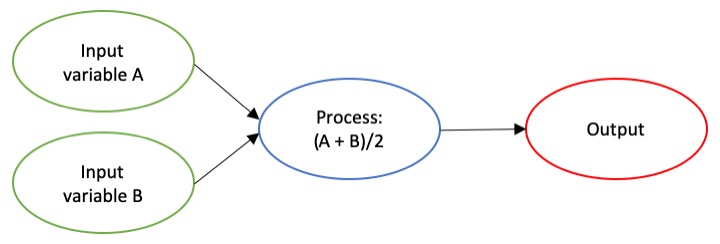
Figure 1. An example of a basic algorithm flow chart. There are two inputs: variables A and B. The process is the calculation of the mean of the two variables.

What is an image?

Think of an image as a spread sheet, where each cell is a pixel and each pixel is assigned a value (Fig. 2). Each value is associated with a color and when the sheet is zoomed out and viewed as a whole, the image comes together.  In color imagery, which is also referred to as RGB, each pixel is associated with the values of the three color bands (red, green, and blue) that make up that color. In a thermal image, each pixel’s value is a temperature value. Thinking about an image as a grid of values is helpful to understand the challenge of translating the larger patterns we see into something the computer can interpret. In image analysis this process can involve using the values of the pixels themselves or the relationships between the values of neighboring pixels.

Figure 2. A diagram illustrating how pixels make up an image. Each pixel is a grid cell associated with certain values. Image Source: https://web.stanford.edu/class/cs101/image-1-introduction.html

Our brains take in the whole picture at once and we are good at identifying the objects and patterns in an image. Take Figure 3 for example: an astute human eye and brain can isolate and identify all the different markings and scars on the fluke. Yet, this process would be very time consuming. The trick to building an algorithm to conduct this work is figuring out what processes or tools are needed to get a computer to recognize what is marking and what is not. This iterative process is the algorithm development.
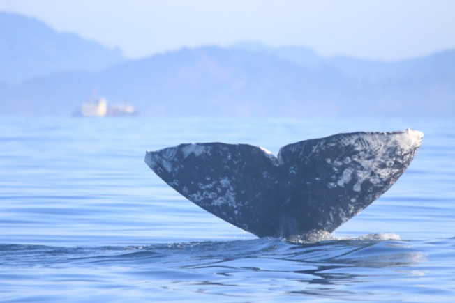
Figure 3. Photo ID image of a gray whale fluke.

Development

An image analysis algorithm will typically involve some sort of thresholding. Thresholds are used to classify an image into groups of pixels that represent different characteristics. A threshold could be applied to the image in Figure 3 to separate the white color of the markings on the fluke from the darker colors in the rest of the image. However, this is an oversimplification, because while it would be pretty simple to examine the pixel values of this image and pick a threshold by hand, this threshold would not be applicable to other images. If a whale in another image is a lighter color or the image is brighter, the pixel values would be different enough from those in the previous image for the threshold to inaccurately classify the image. This problem is why a lot of image analysis algorithm development involves creating parameterized processes that can calculate the appropriate threshold for each image.

One successful method used to determine thresholds in images is to first calculate the frequency of color in each image, and then apply the appropriate threshold. Fletcher et al. (2009) developed a semiautomated algorithm to detect scars in seagrass beds from aerial imagery by applying an equation to a histogram of the values in each image to calculate the threshold. A histogram is a plot of the frequency of values binned into groups (Fig. 4). Essentially, it shows how many times each value appears in an image. This information can be used to define breaks between groups of values. If the image of the fluke were transformed to a gray scale, then the values of the marking pixels would be grouped around the value for white and the other pixels would group closer to black, similar to what is shown in Figure 4. An equation can be written that takes this frequency information and calculates where the break is between the groups. Since this method calculates an individualized threshold for each image, it’s a more reliable method for image analysis. Other characteristics could also be used to further filter the image, such as shape or area.

However, that approach is not the only way to make an algorithm applicable to different images; semi-automation can also be helpful. Semi-automation involves some kind of user input. After uploading the image for analysis, the user could also provide the threshold, or the user could crop the image so that only the important components were maintained. Keeping with the fluke example, the user could crop the image so that it was only of the fluke. This would help reduce the variety of colors in the image and make it easier to distinguish between dark whale and light marking.

Figure 4. Example histogram of pixel values. Source: Moallem et al. 2012

Why algorithms are important

Algorithms are helpful because they make our lives easier. While it would be possible for an analyst to identify and digitize each individual marking from a picture of a gray whale, it would be extremely time consuming and tedious. Image analysis algorithms significantly reduce the time it takes to process imagery. A semi-automated algorithm that I developed to count penguins from still drone imagery can count all the penguins on a one km2 island in about 30 minutes, while it took me 24 long hours to count them by hand (Bird et al. in prep). Furthermore, the process can be repeated with different imagery and analysts as part of a time series without bias because the algorithm eliminates human error introduced by different analysts.

Whether it’s a simple combination of a few processes or a complex series of equations, creating an algorithm requires breaking down a task to its most basic components. Development involves translating those components step by step into an automated process, which after many trials and errors, achieves the desired result. My first algorithm project took two years of revising, improving, and countless trials and errors.  So, whether creating an algorithm or working to understand one, don’t let the jargon nor the endless trials and errors stop you. Like most things in life, the key is to have patience and take it one step at a time.

References

Bird, C. N., Johnston, D.W., Dale, J. (in prep). Automated counting of Adelie penguins (Pygoscelis adeliae) on Avian and Torgersen Island off the Western Antarctic Peninsula using Thermal and Multispectral Imagery. Manuscript in preparation

Fletcher, R. S., Pulich, W. ‡, & Hardegree, B. (2009). A Semiautomated Approach for Monitoring Landscape Changes in Texas Seagrass Beds from Aerial Photography. https://doi.org/10.2112/07-0882.1

Moallem, Payman & Razmjooy, Navid. (2012). Optimal Threshold Computing in Automatic Image Thresholding using Adaptive Particle Swarm Optimization. Journal of Applied Research and Technology. 703.

The significance of blubber hormone sampling in conservation and monitoring of marine mammals

By: Alexa Kownacki, Ph.D. Student, OSU Department of Fisheries and Wildlife, Geospatial Ecology of Marine Megafauna Lab

Marine mammals are challenging to study for many reasons, and specifically because they inhabit the areas of the Earth that are uninhabited by people: the oceans. Monitoring marine mammal populations to gather baselines on their health condition and reproductive status is not as simple as trap and release, which is a method often conducted for terrestrial animals. Marine mammals are constantly moving in vast areas below the surface. Moreover, cetaceans, which do not spend time on land, are arguably the most challenging to sample.

One component of my project, based in California, USA, is a health assessment analyzing hormones of the bottlenose dolphins that frequent both the coastal and the offshore waters. Therefore, I am all too familiar with the hurdles of collecting health data from living marine mammals, especially cetaceans. However, the past few decades have seen major advancements in technology both in the laboratory and with equipment, including one tool that continues to be critical in understanding cetacean health: blubber biopsies.

Biopsy dart hitting a bottlenose dolphin below the dorsal fin. Image Source: NMFS

Blubber biopsies are typically obtained via low-powered crossbow with a bumper affixed to the arrow to de-power it once it hits the skin. The arrow tip has a small, pronged metal attachment to collect an eraser-tipped size amount of tissue with surface blubber and skin. I compare this to a skin punch biopsies in humans; it’s small, minimally-invasive, and requires no follow-up care. With a small team of scientists, we use small, rigid-inflatable vessels to survey the known locations of where the bottlenose dolphins tend to gather. Then, we assess the conditions of the seas and of the animals, first making sure we are collecting from animals without potentially lowered immune systems (no large, visible wounds) or calves (less than one years old). Once we have photographed the individual’s dorsal fin to identify the individual, one person assembles the biopsy dart and crossbow apparatus following sterile procedures when attaching the biopsy tips to avoid infection. Another person prepares to photograph the animal to match the biopsy information to the individual dolphin. One scientist aims the crossbow for the body of the dolphin, directly below the dorsal fin, while the another photographs the biopsy dart hitting the animal and watches where it bounces off. Then, the boat maneuvers to the floating biopsy dart to recover the dart and the sample. Finally, the tip with blubber and skin tissue is collected, again using sterile procedures, and the sample is archived for further processing. A similar process, using an air gun instead of a crossbow can be viewed below:

GEMM Lab members using an air gun loaded with a biopsy dart to procure marine mammal blubber from a blue whale in New Zealand. Video Source: GEMM Laboratory.

Part of the biopsy process is holding ourselves to the highest standards in our minimally-invasive technique, which requires constant practice, even on land.

Alexa practicing proper crossbow technique on land under supervision. Image Source: Alexa Kownacki

Blubber is the lipid-rich, vascularized tissue under the epidermis that is used in thermoregulation and fat storage for marine mammals. Blubber is an ideal matrix for storing lipophilic (fat-loving) steroid hormones because of its high fat content. Steroid hormones, such as cortisol, progesterone, and testosterone, are naturally circulating in the blood stream and are released in high concentrations during specific events. Unlike blood, blubber is less dynamic and therefore tells a much longer history of the animal’s nutritional state, environmental exposure, stress level, and life history status. Blubber is the cribs-notes version of a marine mammal’s biography over its previous few months of life. Blood, on the other hand, is the news story from the last 24 hours. Both matrices serve a specific purpose in telling the story, but blubber is much more feasible to obtain from a cetacean and provides a longer time frame in terms of information on the past.

A simplified depiction of marine mammal blubber starting from the top (most exterior surface) being the skin surface down to the muscle (most interior). Image Source: schoolnet.org.za

I use blubber biopsies for assessing cortisol, testosterone, and progesterone in the bottlenose dolphins. Cortisol is a glucocorticoid that is frequently associated with stress, including in humans. Marine mammals utilize the same hypothalamic-pituitary-adrenal (HPA) axis that is responsible for the fight-or-flight response, as well as other metabolic regulations. During prolonged stressful events, cortisol levels will remain elevated, which has long-term repercussions for an animal’s health, such as lowered immune systems and decreased ability to respond to predators. Testosterone and progesterone are sex hormones, which can be used to indicate sex of the individual and determine reproductive status. This reproductive information allows us to assess the population’s composition and structure of males and females, as well as potential growth or decline in population (West et al. 2014).

Alexa using a crossbow from a small boat off of San Diego, CA. Image Source: Alexa Kownacki

The coastal and offshore bottlenose dolphin ecotypes of interest in my research occupy different locations and are therefore exposed to different health threats. This is a primary reason for conducting health assessments, specifically analyzing blubber hormone levels. The offshore ecotype is found many kilometers offshore and is most often encountered around the southern Channel Islands. In contrast, the coastal ecotype is found within 2 kilometers of shore (Lowther-Thieleking et al. 2015) where they are subjected to more human exposure, both directly and indirectly, because of their close proximity to the mainland of the United States. Coastal dolphins have a higher likelihood of fishery-related mortality, the negative effects of urbanization including coastal runoff and habitat degradation, and recreational activities (Hwang et al. 2014). The blubber hormone data from my project will inform which demographics are most at-risk. From this information, I can provide data supporting why specific resources should be allocated differently and therefore help vulnerable populations. Further proving that the small amount of tissue from a blubber biopsy can help secure a better future for population by adjusting and informing conservation strategies.

Literature Cited:

Hwang, Alice, Richard H Defran, Maddalena Bearzi, Daniela. Maldini, Charles A Saylan, Aime ́e R Lang, Kimberly J Dudzik, Oscar R Guzo n-Zatarain, Dennis L Kelly, and David W Weller. 2014. “Coastal Range and Movements of Common Bottlenose Dolphins (Tursiops Truncatus) off California and Baja California, Mexico.” Bulletin of the Southern California Academy of Sciences 113 (1): 1–13. https://doi.org/10.3390/toxins6010211.

Lowther-Thieleking, Janet L., Frederick I. Archer, Aimee R. Lang, and David W. Weller. 2015. “Genetic Differentiation among Coastal and Offshore Common Bottlenose Dolphins, Tursiops Truncatus, in the Eastern North Pacific Ocean.” Marine Mammal Science 31 (1): 1–20. https://doi.org/10.1111/mms.12135.

West, Kristi L., Jan Ramer, Janine L. Brown, Jay Sweeney, Erin M. Hanahoe, Tom Reidarson, Jeffry Proudfoot, and Don R. Bergfelt. 2014. “Thyroid Hormone Concentrations in Relation to Age, Sex, Pregnancy, and Perinatal Loss in Bottlenose Dolphins (Tursiops Truncatus).” General and Comparative Endocrinology 197: 73–81. https://doi.org/10.1016/j.ygcen.2013.11.021.

Is there life after graduate school?

By Amanda Holdman, MS, GEMM Lab Alumni 2016

I graduated in March 2017 from the GEMM lab at Oregon State, with a Master’s of Science in Wildlife Management. Graduate school was finally over! No more constant coffee refills, popcorn dinners and overnight library stays; I had submitted my final thesis and I was done! Graduate school was no walk in the park for me, and finishing a master’s or a doctorate degree for anyone is no easy feat! It takes years of hard work, commitment, long hours, and a dedication to learning. I remember feeling both excited and a bit disoriented to be done with this phase of much stress and growth. After submitting my thesis, I took a much-needed month off to unknot the muscles in my back and get myself reacquainted with sunlight. The breath of fresh air was exactly what I needed to recover, but it took no time at all for a new type of challenge to emerge: the arduous task of finding a job.

I did what most job seekers do, I sat behind my computer applying for opportunities, hit as many roles as I could, and hoped for the best. Days turned into weeks and weeks turned into months. I was getting desperate, I resorted to applying for a whole spectrum of roles – consulting, project management, administration, youth team leader – hoping that something would land. Soon enough, almost 3 months had passed and I was still in the same spot as before. I was ready to throw in the towel.

In theory, landing a job after graduation sounds like it should be technically easy because more education should mean you are more qualified for the job, but anyone who has been out of grad school for more than an hour can tell you that landing a job after graduate school can be a long and frustrating process. I did not enter this field and its job prospects blindly – that is, I had a working idea of what type of research career I wanted when I completed my education and how much education I would need to get there. I was aware that navigating the job market in a competitive field could be tricky and time-consuming, especially as a green-job seeker. I knew it would be an added difficulty to land a position near the ocean but also close enough to family (I’m from the Midwest). Or at least, I thought I knew how hard it would be to secure a job. The process turned out to be much harder. Mental preparation alone was not enough and months and months of rejection and feeling stuck within the hamster wheel of the job search cycle was becoming my normal.

So, when I was stuck in the depths of a seemingly fruitless job search, and trying as hard as I possibly could, it was hard for me to do anything but roll my eyes, sigh, and give up. But I had to find a way to work through an apparently endless string of rejection by figuring out some way to accept, address and navigate my emotions. I needed to take charge of my own personal development. I started reflecting on what areas of my work on my master’s thesis that I found most difficult and wanted to improve, and would be  an important component of the job I wanted. Identifying my own “knowledge gaps” led me to seek out courses, workshops, job-shadowing and online courses that could fill those holes.

The first thing at the top of my list was to be more efficient at coding. Every job description that made me excited to apply had some description of a coding program: R, Python, MATLAB.  I was lucky enough to attend courses and workshops during my time at the GEMM lab that provided me much of the code I would need to create my habitat models with minimal tweaking. On top of that I was surrounded by supervisors and a lab full of coding geniuses that had an almost, if not completely, open door policy. When I was stuck and a deadline was quickly approaching, it was great to have an army of people to help me get through my obstacles. However, I knew if I wanted to be successful, I needed to become like them: experts and not a beginner. I purchased a subscription to DataCamp, and started searching out courses that could help keep my skills fresh and learn new things. I was over the moon to discover the course “Where are the Fishes?”. It checked all my boxes: geospatial analysis, R, marine related, acoustics…. perfect. Within this course, there were plenty of DataCamp prerequisites, like working with data in the tidyverse and working with dates and times in R, so I had plenty to keep me busy.

I also started looking for in-person, hands-on courses I could enroll in. Since the majority of my marine experience took place on the west coast but I was searching for jobs on the east coast, I enrolled in the Marine Mammal and Sea Turtle Observer Certification Course for the US Atlantic and Gulf of Mexico Oceans in order to learn a little more about identifying species I did not commonly see in nearshore, northern Pacific waters. In this course, I learned about regulations surrounding protected species monitoring, proper camera settings for photographing marine life, and gained the certification needed to work as an observer during seismic surveys for Bureau of Ocean Energy Management (BOEM) and Bureau of Safety and Environmental Enforcement (BSEE) in coordination with the National Marine Fisheries Service. Most of these topics were familiar to me, other than identifying new species, but it was nice to have the refresher and the renewed certification. Heads up this course is coming to Newport in October and I highly recommend it! During this observer course in Charleston, I was able to network with others in the field taking the course, the Charleston aquarium, and the South Carolina DNR. By introducing myself and providing a little bit of my background, I was invited by the South Carolina DNR to watch a satellite tag and release of a sea turtle that the aquarium had been rehabilitating. From the sea turtle release I learned of the International Sea Turtle Symposium that would take place in February in Myrtle Beach, North Carolina and was invited to attend and network by one of the conference chairs, which lead me to my current position. See below…

I tried everything I could to keep myself attached to the field. I attended the Biannual Marine Mammal Conference, enrolled in a bioacoustics short course, watched webinars every Friday, read recent journal articles, looked for voluntary work. I even dropped in on offices like NOAA or Universities of towns I was driving through or visiting to see what they were researching, and if they were looking for researchers. Continuous learning and developing took a lot of time, money, and energy but being conscientious about my personal development kept me motivated and engaged. Graduate school prepared me for all of this. My GEMM lab experience taught me to be open to learning, to be flexible and adaptable, to accept, overcome and learn from failures and find solutions. In fact, graduate school provided me a variety of skills that have been transferable to almost everything I have done since graduation.

In December of 2017, I began volunteering at the University of Alabama, Birmingham, under the supervision of Dr. Thane Wibbels, and I began to use those skills I learned from graduate school more than ever. Flash forward and I am now part of a team, called the Kemp’s Ridley Working Group, which is made up of researchers from state, federal and international agencies working together on conservation strategies and programs for Kemp’s Ridley Sea Turtles. Specifically, we are hoping to identify the cues Kemp’s Ridley sea turtles are using to control arribadas (synchronized, large-scale nesting behaviors) in Rancho Nuevo, Mexico. We have a long-term dataset on the number of nests and weather conditions during arribadas from 2007 to 2019 collected using a variety of methods that we are trying to standardize and analyze. Historically, the number of nests has been counted by hand, but over the last few years Dr. Wibbels and his lab have worked to create a protocol for using drones to track the number of sea turtle nests, which has been highly successful. In 2018, the drone recorded the largest sea turtle arribada in 30 years, which consisted of about 4,000 Kemp’s Ridley sea turtle nests within 900 meters of beach.

June 2018 Kemp’s Ridley Sea Turtle Arribada, Rancho Nuevo, Mexico

It’s ironic how incredibly similar my current project is to my master’s thesis I am gathering environmental data from weather stations and remote sensing to analyze tides, currents, wind speed, wind direction, water temperature, air temperature, salinity, etc. in relation to these large arribadas. I am arguably much faster at this process than I was before due to my GEMM lab experience.  I am quickly able to recognize when something isn’t right, and am able to debug where I went wrong. I feel comfortable contributing new ideas and approaches of how to standardize data from old and new technology, how close to fly drones to the animals to capture the data we need without animal disturbance, and at what scales to look for temporal and spatial patterns within our data. The GEMM lab allowed me to gain knowledge through my own work and by association of my lab mates projects, trials and tribulations that have directly transferred into what I am doing now. I am still grant-writing, presenting, collaborating, managing time, and mentoring – all of which I learned in graduate school. I am also still coding, and I have joined a local coding group in Birmingham, Bham Quants, and have been asked to give a series of lectures called “Introduction to R”. The GEMM lab and my own drawn-out job-hunting process allowed me to end up in the position that I am in today, and the struggles and cycle of no’s I heard along the way led me to these opportunities that I am so grateful that I took.

Building on the foundation of my GEMM lab experience, adding my personal development and a couple of years of post-graduate work experience, I no longer feel disoriented. I feel like I have an identity and I know how I want to market myself in the future. I have always considered myself a spatial ecologist, as this is the GEMM labs specializes in, but now I know I’m more of a generalist in terms of species, methods, models and analysis and I want to continue learning and growing in this field to become a jack-of-all-trades. I’ve always had a love for the marine environment, but I also know I have the skills and confidence to transition into terrestrial if I need to. I have fallen in love with geospatial ecology and it isn’t a field that would have even been on my radar, if I had not met Leigh almost 5 years ago *gasp*. Working and studying in the GEMM lab opened up doors for me that I will appreciate for the rest of my life. My advice for anyone studying and working in this field is to stay alert with your eye always on the next step, poised for the next opportunity, whatever it is: to present a paper, attend a conference, meet a scholar in your field, forge a connection, gain a professional skill. There are tons of opportunities (and jobs) that are never posted online, which you will only find out about if you talk to people in your personal network or start knocking on doors. You never know where these doors might lead.

Lingering questions on the potential to bring sea otters back to Oregon

By Dominique Kone, Masters Student in Marine Resource Management

By now, I’m sure you’re aware of recent interests to reintroduce sea otters to Oregon. To inform this effort, my research focuses on predicting suitable sea otter habitat and investigating the potential ecological effects if sea otters are reintroduced in the future. This information will help managers gain a better understanding of the potential for sea otters to reestablish in Oregon, as well as how Oregon’s ecosystems may change via top-down processes. These analyses will address some sources of uncertainties of this effort, but there are still many more questions researchers could address to further guide this process. Here, I note some lingering questions I’ve come across in the course of conducting my research. This is not a complete list of all questions that could or should be investigated, but they represent some of the most interesting questions I have and others have in Oregon.

Credit: Todd Mcleish

The questions, and our associated knowledge on each of these topics:

Is there enough available prey to support a robust sea otter population in Oregon?

Sea otters require approximately 30% of their own body weight in food every day (Costa 1978, Reidman & Estes 1990). With a large appetite, they not only need to spend most of their time foraging, but require a steady supply of prey to survive. For predators, we assume the presence of suitable habitat is a reliable proxy for prey availability (Redfern et al. 2006). Whereby, quality habitat should supply enough prey to sustain predators at higher trophic levels.

In making these habitat predictions for sea otters, we must also recognize the potential limitations of this “habitat equals prey” paradigm, in that there may be parcels of habitat where prey is unavailable or inaccessible. In Oregon, there could be unknown processes unique to our nearshore ecosystems that would support less prey for sea otters. This possibility highlights the importance of not only understanding how much suitable habitat is available for foraging sea otters, but also how much prey is available in these habitats to sustain a viable otter population in the future. Supplementing these habitat predictions with fishery-independent prey surveys is one way to address this question.

Credit: Suzi Eszterhas via Smithsonian Magazine

How will Oregon’s oceanographic seasonality alter or impact habitat suitability?

Sea otters along the California coast exist in an environment with persistent Giant kelp beds, moderate to low wave intensity, and year-round upwelling regimes. These environmental variables and habitat factors create productive ecosystems that provide quality sea otter habitat and a steady supply of prey; thus, supporting high densities of sea otters. This environment contrasts with the Oregon coast, which is characterized by seasonal changes in bull kelp and wave intensity. Summer months have dense kelp beds, calm surf, and strong upwellings. While winter months have little to no kelp, weak upwellings, and intense wave climates. These seasonal variations raise the question as to how these temporal fluctuations in available habitat could impact the number of sea otters able to survive in Oregon.

In Washington – an environment like Oregon – sea otters exhibit seasonal distribution patterns in response to intensifying wave climates. During calm summer months, sea otters primarily forage along the outer coast, but move into more protected areas, such as the Strait of Juan de Fuca, during winter months (Laidre et al. 2009). If sea otters were reintroduced to Oregon, we may very well observe similar seasonal movement patterns (e.g. dispersal into estuaries), but the degree to which this seasonal redistribution and reduction in foraging habitat could impact sea otter reestablishment and recovery is currently unknown.

Credit: Oregon Coast Aquarium

In the event of a reintroduction, do northern or southern sea otters have a greater capacity to adapt to Oregon environments?

In the early 1970’s, Oregon’s first sea otter translocation effort failed (Jameson et al. 1982). Since then, hypotheses on the potential ecological differences between northern and southern sea otters have been proposed as potential factors of the failed effort, potentially due to different abilities to exploit specific prey species. Studies have demonstrated that northern and southern sea otters have slight morphological differences – northern otters having larger skulls and teeth than southern otters (Wilson et al. 1991). This finding has created the hypothesis that the northern otter’s larger skull and teeth allow it to consume prey with denser exoskeletons, and thereby can exploit a greater diversity of prey species. However, there appears to be a lack of evidence to suggest larger skulls and teeth translate to greater bite force. Based on morphology alone, either sub-species could be just as successful in exploiting different prey species.

A different direction to address questions around adaptability is to look at similarities in habitat and oceanographic characteristics. Sea otters exist along a gradient of habitat types (e.g. kelp forests, estuaries, soft-sediment environments) and oceanographic conditions (e.g. warm-temperature to cooler sub-Arctic waters) (Laidre et al. 2009, Lafferty et al. 2014). Yet, we currently don’t know how well or quickly otters can adapt when they expand into new habitats that differ from ones they are familiar with. Sea otters must be efficient foragers and need to acquire skills that allow them to effectively hunt specific prey species (Estes et al. 2003). Hypothetically, if we take sea otters from rocky environments where they’ve developed foraging skills to hunt sea urchins and abalones, and place them in a soft-sediment environment, how quickly would they develop new foraging skills to exploit soft-sediment prey species? Would they adapt quickly enough to meet their daily prey requirements?

Credit: Eric Risberg/Associated Press via The Columbian

In Oregon, specifically, how might climate change impact sea otters, and how might sea otters mediate climate impacts?

Climate change has been shown to directly impact many species via changes in temperature (Chen et al. 2011). Some species have specific thermal tolerances, in which they can only survive within a specified temperature range (i.e. maximum and minimum). Once the temperature moves out of that range, the species can either move with those shifting water masses, behaviorally adapt or perish (Sunday et al. 2012). It’s unclear if and how changing temperatures will impact sea otters, directly. However, sea otters could still be indirectly affected via impacts to their prey. If prey species in sea otter habitat decline due to changing temperatures, this would reduce available food for otters. Ocean acidification (OA) is another climate-induced process that could indirectly impact sea otters. By creating chemical conditions that make it difficult for species to form shells, OA could decrease the availability of some prey species, as well (Gaylord et al. 2011).

Interestingly, these pathways between sea otters and climate change become more complex when we consider the potentially mediating effects from sea otters. Aquatic plants – such as kelp and seagrass – can reduce the impacts of climate change by absorbing and taking carbon out of the water column (Krause-Jensen & Duarte 2016). This carbon sequestration can then decrease acidic conditions from OA and mediate the negative impacts to shell-forming species. When sea otters catalyze a tropic cascade, in which herbivores are reduced and aquatic plants are restored, they could increase rates of carbon sequestration. While sea otters could be an effective tool against climate impacts, it’s not clear how this predator and catalyst will balance each other out. We first need to investigate the potential magnitude – both temporal and spatial – of these two processes to make any predictions about how sea otters and climate change might interact here in Oregon.

Credit: National Wildlife Federation

In Summary

There are several questions I’ve noted here that warrant further investigation and could be a focus for future research as this potential sea otter reintroduction effort progresses. These are by no means every question that should be addressed, but they do represent topics or themes I have come across several times in my own research or in conversations with other researchers and managers. I think it’s also important to recognize that these questions predominantly relate to the natural sciences and reflect my interest as an ecologist. The number of relevant questions that would inform this effort could grow infinitely large if we expand our disciplines to the social sciences, economics, genetics, so on and so forth. Lastly, these questions highlight the important point that there is still a lot we currently don’t know about (1) the ecology and natural behavior of sea otters, and (2) what a future with sea otters in Oregon might look like. As with any new idea, there will always be more questions than concrete answers, but we – here in the GEMM Lab – are working hard to address the most crucial ones first and provide reliable answers and information wherever we can.

References:

Chen, I., Hill, J. K., Ohlemuller, R., Roy, D. B., and C. D. Thomas. 2011. Rapid range shifts of species associated with high levels of climate warming. Science. 333: 1024-1026.

Costa, D. P. 1978. The ecological energetics, water, and electrolyte balance of the California sea otter (Enhydra lutris). Ph.D. dissertation, University of California, Santa Cruz.

Estes, J. A., Riedman, M. L., Staedler, M. M., Tinker, M. T., and B. E. Lyon. 2003. Individual variation in prey selection by sea otters: patterns, causes and implications. Journal of Animal Ecology. 72: 144-155.

Gaylord et al. 2011. Functional impacts of ocean acidification in an ecologically critical foundation species. Journal of Experimental Biology. 214: 2586-2594.

Jameson, R. J., Kenyon, K. W., Johnson, A. M., and H. M. Wight. 1982. History and status of translocated sea otter populations in North America. Wildlife Society Bulletin. 10(2): 100-107.

Krause-Jensen, D., and C. M. Duarte. 2016. Substantial role of macroalgae in marine carbon sequestration. Nature Geoscience. 9: 737-742.

Lafferty, K. D., and M. T. Tinker. 2014. Sea otters are recolonizing southern California in fits and starts. Ecosphere.5(5).

Laidre, K. L., Jameson, R. J., Gurarie, E., Jeffries, S. J., and H. Allen. 2009. Spatial habitat use patterns of sea otters in coastal Washington. Journal of Marine Mammalogy. 90(4): 906-917.

Redfern et al. 2006. Techniques for cetacean-habitat modeling. Marine Ecology Progress Series. 310: 271-295.

Reidman, M. L. and J. A. Estes. 1990. The sea otter (Enhydra lutris): behavior, ecology, and natural history. United States Department of the Interior, Fish and Wildlife Service, Biological Report. 90: 1-126.

Sunday, J. M., Bates, A. E., and N. K. Dulvy. 2012. Thermal tolerance and the global redistribution of animals. Nature: Climate Change. 2: 686-690.

Wilson, D. E., Bogan, M. A., Brownell, R. L., Burdin, A. M., and M. K. Maminov. 1991. Geographic variation in sea otters, Ehydra lutris. Journal of Mammalogy. 72(1): 22-36.

Eyes from Space: Using Remote Sensing as a Tool to Study the Ecology of Blue Whales

By Christina Garvey, University of Maryland, GEMM Lab REU Intern

It is July 8th and it is my 4th week here in Hatfield as an REU intern for Dr. Leigh Torres. My name is Christina Garvey and this summer I am studying the spatial ecology of blue whales in the South Taranaki Bight, New Zealand. Coming from the east coast, Oregon has given me an experience of a lifetime – the rugged shorelines continue to take my breath away and watching sea lions in Yaquina Bay never gets old. However, working on my first research project has by far been the greatest opportunity and I have learned so much in so little time. When Dr. Torres asked me to contribute to this blog I was unsure of how I would write about my work thus far but I am excited to have the opportunity to share the knowledge I have gained with whoever reads this blog post.

The research project that I will be conducting this summer will use remotely sensed environmental data (information collected from satellites) to predict blue whale distribution in the South Taranaki Bight (STB), New Zealand. Those that have read previous blogs about this research may remember that the STB study area is created by a large indentation or “bight” on the southern end of the Northern Island. Based on multiple lines of evidence, Dr. Leigh Torres hypothesized the presence of an unrecognized blue whale foraging ground in the STB (Torres 2013). Dr. Torres and her team have since proved that blue whales frequent this region year-round; however, the STB is also very industrial making this space-use overlap a conservation concern (Barlow et al. 2018). The increasing presence of marine industrial activity in the STB is expected to put more pressure on blue whales in this region, whom are already vulnerable from the effects of past commercial whaling (Barlow et al. 2018) If you want to read more about blue whales in the STB check out previous blog posts that talk all about it!

Figure 1. A blue whale surfaces in front of a floating production storage and offloading vessel servicing the oil rigs in the South Taranaki Bight. Photo by D. Barlow.

Figure 2. South Taranaki Bight, New Zealand, our study site outlined by the red box. Kahurangi Point (black star) is the site of wind-driven upwelling system.

The possibility of the STB as an important foraging ground for a resident population of blue whales poses management concerns as New Zealand will have to balance industrial growth with the protection and conservation of a critically endangered species. As a result of strong public support, there are political plans to implement a marine protected area (MPA) in the STB for the blue whales. The purpose of our research is to provide scientific knowledge and recommendations that will assist the New Zealand government in the creation of an effective MPA.

In order to create an MPA that would help conserve the blue whale population in the STB, we need to gather a deeper understanding of the relationship between blue whales and this marine environment. One way to gain knowledge of the oceanographic and ecological processes of the ocean is through remote sensing by satellites, which provides accessible and easy to use environmental data. In our study we propose remote sensing as a tool that can be used by managers for the design of MPAs (through spatial and temporal boundaries). Satellite imagery can provide information on sea surface temperature (SST), SST anomaly, as well as net primary productivity (NPP) – which are all measurements that can help describe oceanographic upwelling, a phenomena that is believed to be correlated to the presence of blue whales in the STB region.

Figure 3. The stars of the show: blue whales. A photograph captured from the small boat of one animal fluking up to dive down as another whale surfaces close by. (Photo credit: L. Torres)

Past studies in the STB showed evidence of a large upwelling event that occurs off the coast of Kahurangi Point (Fig. 2), on the northwest tip of the South Island (Shirtcliffe et al. 1990). In order to study the relationship of this upwelling to the distribution of blue whales, I plan to extract remotely sensed data (SST, SST anomaly, & NPP) off the coast of Kahurangi and compare it to data gathered from a centrally located site within the STB, which is close to oil rigs and so is of management interest. I will first study how decreases in sea surface temperature at the site of upwelling (Kahurangi) are related to changes in sea surface temperature at this central site in the STB, while accounting for any time differences between each occurrence. I expect that this relationship will be influenced by the wind patterns, and that there will be changes based on the season. I also predict that drops in temperature will be strongly related to increases in primary productivity, since upwelling brings nutrients important for photosynthesis up to the surface. These dips in SST are also expected to be correlated to blue whale occurrence within the bight, since blue whale prey (krill) eat the phytoplankton produced by the productivity.

Figure 4. A blue whale lunges on an aggregation of krill. UAS piloted by Todd Chandler.

To test the relationships I determine between remotely sensed data at different locations in the STB, I plan to use blue whale observations from marine mammal observers during a seismic survey conducted in 2013, as well as sightings recorded from the 2014, 2016, and 2017 field studies led by Dr. Leigh Torres. By studying the statistical relationships between all of these variables I hope to prove that remote sensing can be used as a tool to study and understand blue whale distribution.

I am very excited about this research, especially because the end goal of creating an MPA really gives me purpose. I feel very lucky to be part of a project that could make a positive impact on the world, if only in just a little corner of New Zealand. In the mean time I’ll be here in Hatfield doing the best I can to help make that happen.

References: 

Barlow DR, Torres LG, Hodge KB, Steel D, Baker CS, Chandler TE, Bott N, Constantine R, Double MC, Gill P, Glasgow D, Hamner RM, Lilley C, Ogle M, Olson PA, Peters C, Stockin KA, Tessaglia-hymes CT, Klinck H (2018) Documentation of a New Zealand blue whale population based on multiple lines of evidence. Endanger Species Res 36:27–40.

Shirtcliffe TGL, Moore MI, Cole AG, Viner AB, Baldwin R, Chapman B (1990) Dynamics of the Cape Farewell upwelling plume, New Zealand. New Zeal J Mar Freshw Res 24:555–568.

Torres LG (2013) Evidence for an unrecognised blue whale foraging ground in New Zealand. New Zeal J Mar Freshw Res 47:235–248.

Our GEM(M), Ruby, is back in action!

By Lisa Hildebrand, MSc student, OSU Department of Fisheries and Wildlife, Geospatial Ecology of Marine Megafauna Lab

Every season, or significant period of time, usually has a distinct event that marks its beginning. For example, even though winter officially begins when the winter solstice occurs sometime between December 20 and December 23, many people often associate the first snowfall as the real start of winter. To mark the beginning of schooling, when children start 1stgrade in Germany (which is where I’m from), they receive something called a “Zuckertüte”, which translated means “sugar bag”. It is a large (sometimes as large as the child) cone-shaped container made of cardboard filled with toys, chocolates, sweets, school supplies and various other treats topped with a large bow.

Receiving my Zuckertüte in August of 2001 before starting 1st grade. Source: Ines Hildebrand.

I still remember (and even have) mine – it was almost as tall as I was, had a large Barbie printed on it (and a real one sitting on top of it) and was bright pink. And of course, while at a movie theatre, once the lights dim completely and the curtain surrounding the screen opens just a little further, members of the audience stop chit-chatting or sending text messages, everyone quietens down and puts their devices away – the film is about to start. There are hundreds upon thousands of examples like these – moments, events, days that mark the start of something.

In the past, the beginning of summer has always been tied to two things for me: the end of school and the chance to be outside in the sun for many hours and days. This reality has changed slightly since moving to Oregon. While I don’t technically have any classes during the summer, the work definitely won’t stop. There are still dozens of papers to read, samples to run in the lab, and data points to plot. For anyone from Oregon or the Pacific Northwest (PNW), it’s pretty well known that the weather can be a little unpredictable and variable, meaning that summer might not always be filled with sunny days. Despite somewhat losing these two “summer markers”, I have found a new event to mark the beginning of summer – the arrival of the gray whales.

Their propensity for coastal waters and near-shore feeding is part of what makes gray whales so unique and arguably “easier” to study than some other baleen whale species. Image captured under NOAA/NMFS permit #21678. Source: Leigh Torres.


It’s official – the gray whale field season is upon us! As many of you may already know, the GEMM Lab has two active gray whale research projects: investigating the impacts of ocean noise on gray whale physiology and exploring potential individual foraging specialization among the Pacific Coast Feeding Group (PCFG) gray whales. Both projects involve field work, with the former operating out of Newport and the latter taking place in Port Orford, both collecting photographs and a variety of samples and tracklines to study the PCFG, which is a sub-group of the larger Eastern North Pacific (ENP) population. June 1st is the widely accepted “cut-off date” for the PCFG whales, whereby gray whales seen after June 1st along the PNW coastline (specifically northern California, Oregon, Washington and British Columbia) are considered members of the PCFG. While this date is not the only qualifying factor for an individual to be considered a PCFG member, it is a good general rule of thumb. Since last week happened to be the first week of June, PI Leigh Torres, field technician Todd Chandler and myself launched out onto the Pacific Ocean in our trusty RHIB Ruby twice looking for gray whales, and it sure was a successful start to the season!

Even though I have done small boat-based field work before, every project and field team operates a little differently, which is why I was a little nervous at first. There are a lot of components to the Newport-based project as Leigh & co. assess gray whale physiology by collecting fecal samples, drone imagery and taking photographs, observing behavior patterns, as well as assessing local prey through GoPro footage and light traps. I wasn’t worried about the prey components of the research, since there is plenty of prey sampling involved in my Port Orford research, however I was worried about the whale side of things. I wasn’t sure whether I would be able to catch the drone as it returned back home to Ruby, fearing I might fumble and let it slip through my fingers. I also experienced slight déjà vu when handling the net we use to collect the fecal samples as I was forced to think back to some previous field work that involved collecting a biopsy dart with a net as well. During that project, I had somehow managed to get the end of the net stuck in the back of the boat and as I tried to scoop up the biopsy dart with the net-end, the pole became more and more stuck while the water kept dragging the net-end down and eventually the pole ended up snapping in my hands. On top of all this anxiety and work, trying to find your footing in a small RHIB like Ruby packed with lots of gear and a good amount of swell doesn’t make any of those tasks any easier.

However, as it turned out, none of my fears came to fruition. As soon as Todd fired up Ruby’s engine and we whizzed out and under the Newport bridge, I felt exhilarated. I love field work and was so excited to be out on the water again. During the two days I was able to observe multiple individuals of a species of whale that I find unique and fascinating.

Markings and pigmentation on the flukes are also unique to individuals and allow us to perform photo identification to track individuals over months and years. Image captured under NOAA/NMFS permit #21678. Source: Leigh Torres.

I felt back in my natural element and working with Leigh and Todd was rewarding and fun, as I have so much to learn from their years of experience and natural talent in the field dealing with stressful situations and juggling multiple components and gear. Even though I wasn’t out there collecting data for my own project, some of my observations did get me thinking about what I hope to focus on in my thesis – individualization. It is always interesting to see how differently whales will behave, whether due to the substrate we find them over, the water depths we find them in, or what their surfacing patterns are like. Although I still have six weeks to go until my field season starts and feel lucky to have the opportunity to help Leigh and Todd with the Newport field work, I am already looking forward to getting down to Port Orford in mid-July and starting the fifth consecutive gray whale field season down there.

But back to Newport – over the course of two days, we were able to deploy and retrieve one light trap to collect zooplankton, collect two fecal samples, perform two GoPro drops, fly the drone three times, and take hundreds of photos of whales. Leigh and Todd were both glad to be reunited with an old friend while I felt lucky to be able to meet such a famous lady – Scarback. A whale with a long sighting history not just for the GEMM Lab but for various researchers along the coast that study this population. Scarback is well-known (and easily identified) by the large concave injury on her back that is covered in whale lice, or cyamids. While there are stories about how Scarback’s wound came to be, it is not known for sure how she was injured. However, what researchers do know is that the wound has not stopped this female from reproducing and successfully raising several calves over her lifetime. After hearing her story from Leigh, I wasn’t surprised that both she and Todd were so thrilled to get both a fecal sample and a drone flight from her early in the season. The two days weren’t all rosy; most of day 1 was shrouded in a cloud of mist resulting in a thin but continuous layer of moisture forming on our clothes, while on day 2 we battled with some pretty big swells (up to 6 feet tall) and in typical Oregon coast style we were victims of a sudden downpour for about 10 minutes. We had some excellent sightings and some not-so-excellent sightings. Sightings where we had four whales surrounding our boat at the same time and sightings where we couldn’t re-locate a whale that had popped up right next to us. It happens.


A local celebrity – Scarback. Image captured under NOAA/NMFS permit #21678. Source: Lisa Hildebrand.


An ecstatic Lisa with wild hair standing in the bow pulpit of Ruby camera at the ready. Source: Leigh Torres.

Field work is certainly one of my favorite things in the world. The smell of the salt, the rustling of cereal bar wrappers, the whipping of hair, the perpetual rosy noses and cheeks no matter how many times you apply and re-apply sunscreen, the awkward hilarity of clambering onto the back of the boat where the engine is housed to take a potty break, the whooshing sound of a blow, the sometimes gentle and sometimes aggressive rocking of the boat, the realization that you haven’t had water in four hours only to chug half of your water in a few seconds, the waft of peanut butter and jelly sandwiches, the circular footprint where a whale has just gracefully dipped beneath the surface slipping away from view. I don’t think I will ever tire of any of those things.


A Weekend of Inspiration in Marine Science: NWSSMM and Dr. Sylvia Earle!

By Karen Lohman, Masters Student in Wildlife Science, Cetacean Conservation and Genomics Lab, Oregon State University

My name is Karen Lohman, and I’m a first-year student in Dr. Scott Baker’s Cetacean Conservation and Genomics Lab at OSU. Dr. Leigh Torres is serving on my committee and has asked me to contribute to the GEMM lab blog from time to time. For my master’s project, I’ll be applying population genetics and genomics techniques to better understand the degree of population mixing and breeding ground assignment of feeding humpback whales in the eastern North Pacific. In other words, I’ll be trying to determine where the humpback whales off the U.S. West Coast are migrating from, and at what frequency.

Earlier this month I joined the GEMM lab members in attending the Northwest Student Society of Marine Mammalogy Conference in Seattle. The GEMM lab members and I made the trip up to the University of Washington to present our work to our peers from across the Pacific Northwest. All five GEMM lab graduate students, plus GEMM lab intern Acacia Pepper, and myself gave talks presenting our research to our peers. I was able to present preliminary results on the population structure of feeding humpback whales across shared feeding habitat by multiple breeding groups in the eastern North Pacific using mitochondria DNA haplotype frequencies. In the end GEMM lab’s Dawn Barlow took home the “Best Oral Presentation” prize. Way to go Dawn!

A few of the GEMM lab members and me presenting our research at the NWSSMM conference in May 2019 at the University of Washington.

While conferences have a strong networking component, this one feels unique.  It is a chance to network with our peers, who are working through the same challenges in graduate school and will hopefully be our future research collaborators in marine mammal research when we finish our degrees. It’s also one of the few groups of people that understand the challenges of studying marine mammals. Not every day is full of dolphins and rainbows; for me, it’s mostly labwork or writing code to overcome small and/or patchy sample size problems.

All of the CCGL and GEMM Lab members excited to hear Dr. Sylvia Earle’s presentation at Portland State University in May 2019 (from L to R: Karen L., Lisa H., Alexa K., Leila L., Dawn B., and Dom K.) . Photo Source: Alexa Kownacki

On the way back from Seattle we stopped to hear the one and only Dr. Sylvia Earle, talk in Portland. With 27 honorary doctorates and over 200 publications, Dr. Sylvia Earle is a legend in marine science. Hearing a distinguished marine researcher talk about her journey in research and to present such an inspiring message of ocean advocacy was a great way to end our weekend away from normal grad school responsibilities. While the entirety of her talk was moving, one of her final comments really stood out. Near the end of her talk she called the audience to action by saying “Look at your abilities and have confidence that you can and must make a difference. Do whatever you’ve got.” As a first-year graduate student trying to figure out my path forward in research and conservation, I couldn’t think of better advice to end the weekend on.


Should scientists engage in advocacy?

By Dominique Kone, Masters Student in Marine Resource Management

Should scientists engage in advocacy? This question is one of the most debated topics in conservation and natural resource management. Some experts firmly oppose researchers advocating for policy decisions because such actions potentially threaten the credibility of their science. While others argue that with environmental issues becoming more complex, society would benefit from hearing scientists’ opinions and preferences on proposed actions. While both arguments are valid, we must recognize the answer to this question may never be a universal yes or no. As an early-career scientist, I’d like to share some of my observations and thoughts on this topic, and help continue this dialogue on the appropriateness of scientists exercising advocacy.

Policymakers are tasked with making decisions that determine how species and natural resources are managed, and subsequently affect and impact society. Scientists commonly play an integral role in these policy decisions, by providing policymakers with reliable and accurate information so they can make better-informed decisions. Examples include using stock assessments to set fishing limits, incorporating the regeneration capacity of forests into the timing of timber harvest, or considering the distribution of blue whales in permitting seafloor mining projects. Importantly, informing policy with science is very different from scientists advocating on policy issues. To understand these nuances, we must first define these terms.

A scientist considering engaging in policy advocacy. Source: Karen Brey.

According to Merriam-Webster, informing means “to communicate knowledge to” or “to give information to an authority”. In contrast, advocating means “to support or argue for (a cause, policy, etc.)” (Merriam-Webster 2019). People can inform others by providing information without necessarily advocating for a cause or policy. For many researchers, providing credible science to inform policy decisions is the gold standard. We, as a society, do not take issue with researchers supplying policymakers with reliable information. Rather, pushback arises when researchers step out of their role as informants and attempt to influence or sway policymakers to decide in a particular manner by speaking to values. This is advocacy.

Dr. Robert Lackey is a fisheries & political scientist, and one of the prominent voices on this issue. In his popular 2007 article, he explains that when scientists inform policy while also advocating, a conflict of interest is created (Lackey 2007). To an outsider, it can be difficult to distinguish values from scientific evidence when researchers engage in policy discussions. Are they engaging in these discussions to provide reliable information as an honest scientist, or are they advocating for decisions or policies based on their personal preferences? As a scientist, I like to believe most scientists – in natural resource management and conservation – do not engage in policy decisions for their own benefit, and they truly want to see our resources managed in a responsible and sustainable manner. Yet, I also recognize this belief doesn’t negate the fact that when researchers engage in policy discussions, they could advocate for their personal preferences – whether they do so consciously or subconsciously – which makes identifying these conflicts of interest particularly challenging.

Examples of actions scientists take in conducting and reporting research. Actions on the left represent actions of policy advocacy, those on the right do not, and the center is maybe. This graphic was adapted from a policy advocacy graphic from Scott et al. 2007. Source: Jamie Keyes.

It seems much of the unease with researchers exercising advocacy has to do with a lack in transparency about which role the researcher chooses to play during those policy debates. A simple remedy to this dilemma – as Lackey suggested in his paper – could be to encourage scientists to be completely transparent when they are about to inform versus advocate (Lackey 2007). Yet, for this suggestion to work, it would require complete trust in scientists to (1) verbalize and make known whether they’re informing or advocating, and (2) when they are informing, to provide credible and unbiased information. I’ve only witnessed a few scientists do this without ensuing some skepticism, which unfortunately highlights issues around an emerging mistrust of researchers to provide policy-neutral science. This mistrust threatens the important role scientists have played in policy decisions and the relationships between scientists and policymakers.

While much of this discussion has been focused on how researchers and their science are received by policymakers, researchers engaging in advocacy are also concerned with how they are perceived by their peers within the scientific community. When I ask more-senior researchers about their concerns with engaging in advocacy, losing scientific credibility is typically at or near the top of their lists. Many of them fear that once you start advocating for a position or policy decision (e.g. protected areas, carbon emission reduction, etc.), you become known for that one cause, which opens you up to questions and suspicions on your ability to provide unbiased and objective science. Once your credibility as a scientist comes into question, it could hinder your career.

How it sometimes feels when researchers conduct policy-relevant science. Source: Justin DeFreitas.

Conservation scientists are faced with a unique dilemma. They value both biodiversity conservation and scientific credibility. Yet, in some cases, risk or potential harm to a species or ecosystem may outweigh concerns over damage to their credibility, and therefore, may choose to engage in advocacy to protect that species or ecosystem (Horton 2015). Horton’s explanation raises an important point that researchers taking a hands-off approach to advocacy may not always be warranted, and that a researcher’s decision to engage in advocacy will heavily depend on the issue at hand and the repercussions if the researcher does not advocate their policy preferences. Climate change is a great example, where climate scientists are advocating for the use of their science, recognizing the alternative could mean continued inaction on carbon emission reduction and mitigation. [Note: this is called science advocacy, which is slightly different than advocating personal preferences, but this example helps demonstrate my point.]

To revisit the question – should scientists engage in advocacy? Honestly, I don’t have a clear answer, because there is no clear answer. This topic is one that has so many dimensions beyond the few I mentioned in this blog post. In my opinion, I don’t think researchers should have an always yes or always no stance on advocacy. Nor do I think every researcher needs to agree on this topic. A researcher’s decision to engage in advocacy will all depend on context. When faced with this decision, it might be useful to ask yourself the following questions: (1) How much do policymakers trust me? (2) How will my peers perceive me if I choose to engage? (3) Could I lose scientific credibility if I do engage? And (4) What’s at stake if I don’t make my preferences known? Hopefully, the answers to these sub-questions will help you decide whether you should advocate.

References:

Horton, C. C., Peterson, T. R., Banerjee, P., and M. J. Peterson. 2015. Credibility and advocacy in conservation science. Conservation Biology. 30(1): 23-32.

Lackey, R. T. 2007. Science, Scientists, and Policy Advocacy. Conservation Biology. 21(1): 12-17.

Scott et al. (2007). Policy advocacy in science: prevalence, perspectives, and implications for conservation biologists. Conservation Biology. 21(1): 29-35.

Merriam-Webster. 2019. Retrieved from < https://www.merriam-webster.com/ >

Marine Mammal Observing: Standardization is key

By: Alexa Kownacki, Ph.D. Student, OSU Department of Fisheries and Wildlife, Geospatial Ecology of Marine Megafauna Lab

For the past two years, I’ve had the opportunity to be the marine mammal observer aboard the NOAA ship Bell M. Shimada for 10 days in May. Both trips covered transects in the Northern California Current Ecosystem during the same time of year, but things looked very different from my chair on the fly bridge. This trip, in particular, highlighted the importance of standardization, seeing as it was the second replicate of the same area. Other scientists and crew members repeatedly asked me the same questions that made me realize just how important it is to have standards in scientific practices and communicating them.

Northern right whale dolphin porpoising out of the water beside the ship while in transit. May 2019. Image source: Alexa Kownacki

The questions:

  1. What do you actually do here and why are you doing it?
  2. Is this year the same as last year in terms of weather, sightings, and transect locations?
  3. Did you expect to see greater or fewer sightings (number and diversity)?
  4. What is this Beaufort Sea State scale that you keep referring to?

All of these are important scientific questions that influence our hypothesis-testing research, survey methods, expected results, and potential conclusions. Although the entire science party aboard the ship conducted marine science, we all had our own specialties and sometimes only knew the basics, if that, about what the other person was doing. It became a perfect opportunity to share our science and standards across similar, but different fields.

Now, to answer those questions:

  1. a) What do you actually do here and b) why are you doing it?

a) As the only marine mammal observer, I stand watch during favorable weather conditions while the ship is in transit, scanning from 0 to 90 degrees off the starboard side (from the front of the ship to a right angle towards the right side when facing forwards). Meanwhile, an application on an iPad called SeaScribe, records the ship’s exact location every 15 seconds, even when no animal is sighted. This process allows for the collection of absence data, that is, data when no animals are present. The SeaScribe program records the survey lines, along with manual inputs that I add, including weather and observer information. When I spot a marine mammal, I immediately mark an exact location on a hand held GPS, use my binoculars to identify the species, and add information to the sighting on the SeaScribe program, such as species, distance to the sighted animal(s), the degree (angle) to the sighting, number of animals in a group, behavior, and direction if traveling.

b) Marine mammal observing serves many different purposes. In this case, observing collects information about what species are where at what time. By piggy-backing on these large-scale, offshore oceanographic NOAA surveys, we have the unique opportunity to survey along standardized transect lines during different times of the year. From replicate survey data, we can start to form an idea of which species use which areas and what oceanographic conditions may impact species distributions. Currently there is not much consistent marine mammal data collected over these offshore areas between Northern California and Washington State, so our work is aiming to fill this knowledge gap.

Alexa observing on the R/V Shimada in May 2019, all bundled up. Image Source: Alexa Kownacki

  1. What is this Beaufort Sea State scale that you keep referring to?

Great question! It took me a while to realize that this standard measuring tool to estimate wind speeds and sea conditions, is not commonly recognized even among other sea-goers. The Beaufort Sea State, or BSS, uses an empirical scale that ranges from 0-12 with 0 being no wind and calm seas, to 12 being hurricane-force winds with 45+ ft seas. It is frequently referenced by scientists in oceanography, marine science, and climate science as a universally-understood metric. The BSS was created in 1805 by Francis Beaufort, a hydrographer in the Royal Navy, to standardize weather conditions across the fleet of vessels. By the mid-1850s, the BSS was standardized to non-naval use for sailing vessels, and in 1916, expanded to include information specific to the seas and not the sails1. We in the marine mammal observation field constantly collect BSS information while on survey to measure the quality of survey conditions that may impact our observations. BSS data allows us to measure the extent of our survey range, both in the distance that we are likely to sight animals and also the likelihood of sighting anything. Therefore, the BSS scale gives us an important indication of how much absence data we have collected, in addition to presence data.

A description of the Beaufort Sea State Scale. Image source: National Weather Service.


  1. Is this year the same as last year in terms of weather, sightings, and transect locations?

The short answer is no. Observed differences in marine mammal sightings in terms of both species diversity and number of animals between years can be normal. There are many potential explanatory variables, from differences in currents, upwelling strength, El Nino index levels, water temperatures, or, what was obvious in this case: sighting conditions. The weather in May 2019 varied greatly from that in May 2018. Last year, I observed for nearly every day because the Beaufort Sea State (BSS) was frequently less than a four. However, this year, more often than not, the BSS greater than or equal to five. A BSS of 5 equates to approximately 17-21 knots of breeze with 6-foot waves and the water appears to have many “white horses” or pronounced white caps with sea spray. Additionally, mechanical issue with winches delayed and altered our transect locations. Therefore, although multiple transects from May 2018 were also surveyed during May 2019, there were a few lines that do not have data for both cruises.

May 2018 with a BSS 1

May 2019 with a BSS 6


  1. Did you expect to see greater or fewer sightings (number and diversity)?

Knowing that I had less favorable sighting conditions and less amount of effort observing this year, it is not surprising that I observed fewer marine mammals in total count and in species diversity. Even less surprising is that on the day with the best weather, where the BSS was less than a five, I recorded the most sightings with the highest species count. May 2018 felt a bit like a tropical vacation because we had surprisingly sunny days with mild winds, and during May 2019 we had some rough seas with gale force winds. Additionally, as an observer, I need to remove as much bias as possible. So, yes, I had hoped to see beaked whales or orca like I did in May 2018, but I was still pleasantly surprised when I spotted fin whales feeding in May 2019.

Marine Mammal Species Number of Sightings
May 2018 May 2019
Humpback whale 31 6
Northern right whale dolphin 1 2
Pacific white-sided dolphin 3 6
UNID beaked whale 1 0
Cuvier’s beaked whale 1 0
Gray whale 4 1
Minke whale 1 1
Fin whale 4 1
Blue whale 1 0
Transient killer whale 1 0
Dall’s porpoise 2 0
Northern fur seal 1 0
California sea lion 0 1

Pacific white-sided dolphin. Image source: Alexa Kownacki

Standardization is a common theme. Observing between years on standard transects, at set speeds, in different conditions using standardized tools is critical to collecting high quality data that is comparable across different periods. Scientists constantly think about quality control. We look for trends and patterns, similarities and differences, but none of those could be understood without having standard metrics.

The entire science party aboard the R/V Shimada in May 2019, including a marine mammal scientist, phytoplankton scientists, zooplankton scientists, and fisheries scientists, and oceanographers. Image Source: Alexa Kownacki

Literature Cited:

1Oliver, John E. (2005). Encyclopedia of world climatology. Springer.


The “demon whale-biter”, and why I am learning about an elusive little shark

By Dawn Barlow, PhD student, OSU Department of Fisheries and Wildlife, Geospatial Ecology of Marine Megafauna Lab

There is an ancient Samoan legend that upon entry into a certain bay in Samoa, tuna would sacrifice pieces of their flesh to the community chief1. This was the explanation given for fish with circular shaped wounds where a plug of flesh had been removed. Similar round wounds are also observed on swordfish2, sharks3, and marine mammals including whales4,5, dolphins6, porpoises7, and pinnipeds8,9. In 1971, Everet C. Jones posited that the probable cause of these crater wounds was a small shark only 42-56 cm in length, Isistius brasiliensis1. The species was nicknamed “demon whale-biter” by Stewart Springer, who subsequently popularized the common name for the species, cookie cutter shark.

Figure 1. A yellowfin tuna with a circular bite, characteristic of a cookie cutter shark (Isistius brasiliensis). Photo: John Soward.

I am currently preparing a manuscript on blue whale skin condition. While this is only tangentially related to my doctoral research, it is an exciting side project that has encouraged me to stretch my comfort zone as an ecologist. This analysis of skin condition is part of a broader health assessment of blue whales in New Zealand, where we will be linking skin lesion severity with stress and reproductive hormone levels as well as body condition. Before I continue, I owe a major shout-out to Acacia Pepper, a senior undergraduate student at Oregon State University who has been working with me for nearly the past year through the Fisheries and Wildlife mentorship program. Acacia’s rigor in researching methodologies led us to develop a comprehensive protocol that can be applied widely to any cetacean photo-identification catalog. This method allows us to quantify prevalence and severity of different marking types in a standardized manner. Her passion for marine mammal science and interest in the subject matter is enough to excite this ecologist into fascination with wound morphology and blister concavity. Next thing you know, we are preparing a paper for publication together with P.I. Dr. Leigh Torres on a comprehensive skin condition assessment of blue whales that includes multiple markings and lesion types, but for the purpose of this blog post, I will share just a “bite-sized” piece of the story.

Figure 2. Jaws of a cookie cutter shark. Photo: George Burgess.

Back to the demon whale-biter. What do we know about cookie cutter sharks? Not a whole lot, it turns out. They are elusive, and are thought to live in deep (>1,000 m), offshore waters. They are considered to be both an ectoparasite and an ambush predator. Their distribution is tropical and sub-tropical. Much of what we know and assume about their distribution comes from the bite wounds they leave on their prey2.

In New Zealand where we study a unique population of blue whales10, the southernmost record of cookie cutter sharks is ~ 39⁰S11. We found that in our dataset of 148 photo-identified blue whales, 96% were affected by cookie cutter shark bites. Furthermore, 38% were categorized as having “severe” cookie cutter bite wounds or scars. The latitude of our blue whale sightings ranges from 29-48⁰S and blue whales are highly mobile, so any of the whales in our dataset could theoretically swim in and out of the known range of cookie cutter sharks. In our skin condition assessment, we also categorized cookie cutter bite “freshness” and phase of healing as follows:

We wanted to know if the freshness of cookie cutter shark bites was related in to the latitude at which the whales were photographed. Of the whales photographed north of 39⁰S (n=46), 76% had phase 1 or 2 cookie cutter shark bites present. In contrast, 57.1% of whales photographed south of 39⁰S (n=133) had phase 1 or 2 cookie cutter shark bites. It therefore appears that in New Zealand, the freshness of cookie cutter shark bites on blue whales is related to the latitude at which the whales were sighted, with fresher bites being more common at more northerly latitudes.

Figure 3. A whale with fresh cookie cutter shark bites, photographed in the Bay of Islands, latitude 35.164⁰S. Photo courtesy of Dr. Catherine Peters.

Figure 4. A whale with mostly healed cookie cutter shark bites, photographed off of Kaikoura, latitude 42.464⁰S. Photo courtesy of Jody Weir.

In the midst of a PhD on distribution modeling and habitat use of blue whales, I find myself reading about Samoan legends of tuna with missing flesh and descriptions of strange circular lesions from whaling records, and writing a paper about blue whale skin condition. Exciting “side projects” like this one emerge from rich datasets and good collaboration.

References

  1. Jones, E. C. Isistius brasiliensis, a squaloid shark, the probable cause of crater wounds on fishes and cetaceans. Fish. Bull. 69, 791–798 (1971).
  2. Papastamatiou, Y. P., Wetherbee, B. M., O’Sullivan, J., Goodmanlowe, G. D. & Lowe, C. G. Foraging ecology of Cookiecutter Sharks (Isistius brasiliensis) on pelagic fishes in Hawaii, inferred from prey bite wounds. Environ. Biol. Fishes 88, 361–368 (2010).
  3. Hoyos-Padilla, M., Papastamatiou, Y. P., O’Sullivan, J. & Lowe, C. G. Observation of an Attack by a Cookiecutter Shark ( Isistius brasiliensis ) on a White Shark ( Carcharodon carcharias ) . Pacific Sci. 67, 129–134 (2013).
  4. Mackintosh, N. A. & Wheeler, J. F. G. Southern blue and fin whales. Discov. Reports 1, 257–540 (1929).
  5. Best, P. B. & Photopoulou, T. Identifying the ‘demon whale-biter’: Patterns of scarring on large whales attributed to a cookie-cutter shark Isistius sp. PLoS One 11, (2016).
  6. Heithaus, M. R. Predator-prey and competitive interactions between sharks (order Selachii) and dolphins (suborder Odontoceti): A review. J. Zool. 253, 53–68 (2001).
  7. Van Utrecht, W. L. Wounds And Scars In The Skin Of The Common Porpoise, Phocaena Phocaena (L.). Mammalia 23, 100–122 (1959).
  8. Gallo‐Reynoso, J. ‐P & Figueroa‐Carranza, A. ‐L. A COOKIECUTTER SHARK WOUND ON A GUADALUPE FUR SEAL MALE. Mar. Mammal Sci. 8, 428–430 (1992).
  9. Le Boeuf, B. J., McCosker, J. E. & Hewitt, J. Crater wounds on northern elephant seals: the cookiecutter shark strikes again. Fish. Bull. 85, 387–392 (1987).
  10. Barlow, D. R. et al. Documentation of a New Zealand blue whale population based on multiple lines of evidence. Endanger. Species Res. 36, 27–40 (2018).
  11. Dwyer, S. L. & Visser, I. N. Cookie cutter shark (Isistius sp.) bites on cetaceans, with particular reference to killer whales (Orca) (Orcinus orca). Aquat. Mamm. 37, 111–138 (2011).