Time and Tide Wait for No Man

While the rest of Hatfield was still quiet and unstirring in the early morning hours, Ariana de Souza and I were making our way into the Environmental Protection Agency’s Office of Research and Development. We walked down the unusually empty hallway to get suited up. We quickly pulled on our waders and headed out onto the Yaquina bay mudflats with our supervisor, Jim Kaldy. The sun was just starting to say hello, yet the lights around the bay still twinkled against the cloudy sky.

Our goal that morning was to collect over two hundred Zostera marina plants before the tide covered them again. I had the best time crawling around in the mud, despite the early wake up time. There was something serene in the air that morning and the water was surprisingly warm.  

It has been a few weeks since we collected the Zostera marina plants.They are now settled into their new homes in the lab. These plants are a part of an ongoing mesocosm experiment. As the weeks go by, we are monitoring the salinity, dissolved oxygen, pH, chlorophyll a and temperature of the water inside the various tanks. 

Say tuned to hear about how the mesocosm experiment progresses!

King Tides Washing Around My Brain

Hello and welcome back!

King Tides Along the Coast

The past few weeks have been busy busy busy. For the King Tides Project, I have been making a web display to celebrate the 10th season of the Oregon King Tides Photo Initiative! The purpose of the display is to highlight the successes of the project and to educate about climate change and sea level rise on the Oregon coast. Preparing this display has taken hours of planning the order and content of the information, brainstorming meetings with other members of the Oregon Coastal Management Program, and sorting through many photos on our Flickr page!

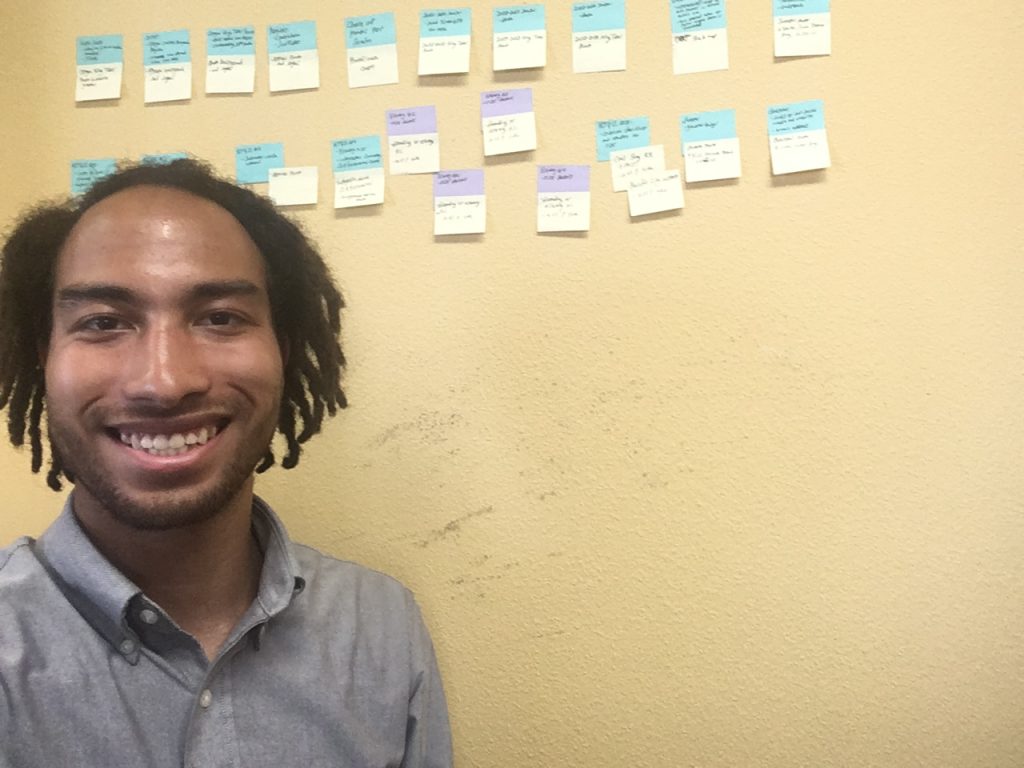
Here is a photo of me with a sticky note map of all of the slides for the presentation!

Another large part of what I have been working on is getting a physical display ready! Hopefully, it will be travelling around in three different venues on the northern, central, and southern Oregon coast (exact locations and dates hopefully in the next post)! In addition to the traveling display, I have been coordinating with the manager of Hatfield Marine Science Center’s Visitors Center to organize a semi-permanent display that will be held there after the king tides season this upcoming winter!

If you want to keep up with what’s been happening with this project, feel free to follow our Instagram, Flickr, and Facebook at the handle of @orkingtide and check out our website: http://oregonkingtides.net!

Okay, moving on from the work talk!

Camping and TACOS!!

Last week, we had our Sea Grant Summer Scholars midsummer check-in! It was really cool seeing all of the projects the other scholars are working on!

During this past weekend, we went on a camping trip as well! Camping in the Umpqua National Forest was beautiful, and especially so for my first time camping in Oregon! We experimented with ingredients in S’mores and I learned that peanut butter cups and graham crackers are some of the best inventions haha. We also had THE BEST TACOS OF MY LIFE at a place called Tacovore!! All in all, super fun trip.

Until next time, sea ya!!

Walking the Wrack Line

***ALERT: Last week of data collection! If you have ever visited Cannon Beach, you are eligible to take the survey and enter to win a bunch of HRAP swag and Sleepy Monk coffee. Just click here to start! ***

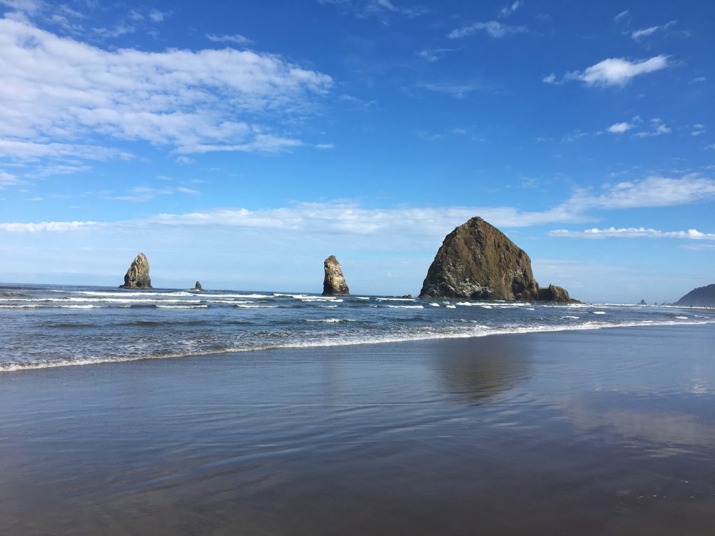
Haystack Rock and the Needles from the South.

During my few weeks of work with the Haystack Rock Awareness Program, I tried to walk to work as much as possible while staying just past Tolovana Park in Cannon Beach. I learned that the crusty, salted line of debris caused by the ebbing tide is called the wrack line; it is here that I have found amazing treasures and intriguing marine life. Identifying the organisms in the wrack line has helped me to become a better Environmental Interpreter as it has made me more knowledgeable of the marine life specific to this region. In most traditional Hawaiian practices the moon phase is very important to kilo, or observations, made in the natural environment. Thus, the following kilo include the Hawaiian names for the different faces of the moon. 

ʻOle Pau, June 23, 2019

My first walk along the wrack line was an experiment to determine how long a commute would take on foot. As I stepped into the sand, the first observation made was the sound — the sand squeaks! Lifting my shoes out of the soft, powdery grains proved laborious, so I found a piece of drift wood to sit on and removed my footwear. Much better! Note taken: just like in Hawaiʻi, it is more efficient to walk barefoot in the sand. At first I was committed to being fully present and experiencing the beach through only organic eyes and not a screen…but this attempt failed when I saw the green, sludgy sea foam I had read about. Mai hopohopo mai — do not worry folks, it is not pollution!

Sea foam tinted green from diatoms!

Diatoms often cause the water to be a greenish color and give bubbles that develop on the shore a greenish tint. Moving on I found a strange arthropod that resembled a marine pill bug, which was being feasted on by other flea like creatures. This was my first run in with mole crabs and their babies — that bite! While attempting to film the frenzy I felt little pinches on my feet that felt like ant bites. Slightly shrieking and dancing away, I know now to move quickly when I see the hopping baby mole crabs so as to not give them time to munch on me. When I finally arrived at Haystack Rock, I found the first of many deceased birds that I would photograph. The contrast of the bustle of visitors at Haystack Rock fawning over the puffins and the sea stars with the floppy corpse of the murre fascinated me.

The lifeless body of a common murre in front of the icon Haystack Rock.

Kāloa Kū Kahi, June 24, 2019

When I stepped on to the beach in the morning, Haystack Rock could barely be seen in the distance through the mist. As I approached were the sea meets the shore, I noticed several progressions of wrack line. Dried lines of salt littered with bits of shell and detritus were evidence of the ebbing tide, which would continue to drop until 11:57 am that morning. I soon stumbled on to the shell of a key hole limpet and a sea gooseberry.

My first sea gooseberry!

Finding the keyhole limpet shell was particularly exciting because it reminded me so much of the opihi we have at home, except for the aperture at the apex of the shell’s point. When I got within the vicinity of Haystack Rock, I came across a pile of gull, the dry, fluffy feathers making it evident that the bird was attacked in air or on land and did not wash up with the tide. The common murre from yesterday was still there. Before leaving the wrack line, my eye spied bright blue debris — plastic! But alas when I picked it up I realized it was bits of egg shell — common murres can have blue eggs!

Not plastic — yay!

Conditions on the walk home were quite a contrast from that morning: blue bird skies, streaky cirrus and sand toasted by the sun. A sea nettle was the first of my discoveries in the wrack line, followed by a lady bug (?!?!), dead manʻs fingers — an algae, not actually, LOTS of dead sea birds and their parts, a tangle of bull kelp and finally some live gulls scavenging the rising tide. 

A sea nettle, a lady bug, dead man’s fingers and bull kelp.

Kāloa Pau, June 26, 2019

I stepped on the beach at 8:04 am to walk to work as the tide just turned from a high of 5.8 ft at 7:45 am. My first wrack line specimen for the day was a piece of coralline algae, of which I have only seen the crustose variety. The structure reminded me of the Halimeda that we have back home, a calcifying algae that contributes greatly to our calcareous sand beaches. Not far from the coralline algae was a clump of feathery cirri from a gooseneck barnacle. As I continued down the beach, bundles of cirri were a common find. I found a key hole limpet shell and a sea gooseberry again, and an intact moon jelly. I also found iridescent sea foam and tube worm casing. The highlight of this walk was definitely the flock of pelicans that were slowly making their way to the Needles. I was able to catch a video of one in flight as it searched for edibles in the water. 

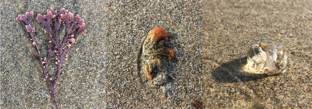
Coralline algae, gooseneck barnacle cirri, and another sea gooseberry.
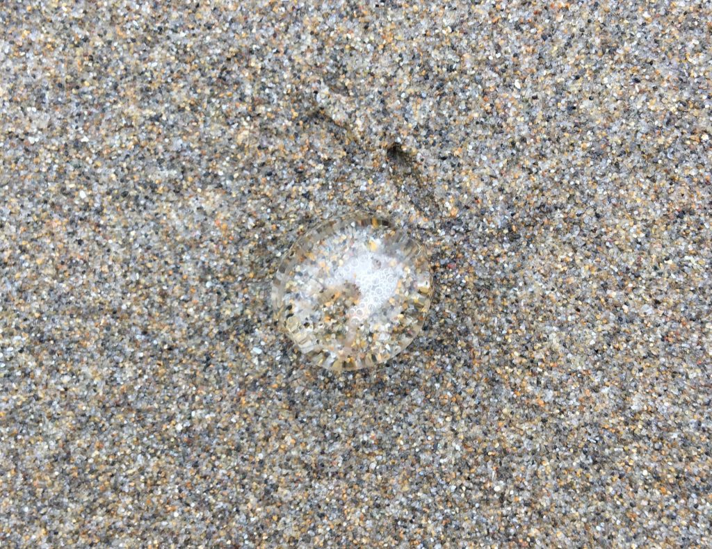
A beautiful moon jelly and some iridescent sea foam!

My first find on the walk home was a sand hopper, which cowered from the shadow of my phone as I tried to film it. Tube worm casing and crab molts littered the wrack line as the tide continued to rise from its bottom out at 1.7 ft at 1:40 pm. I also found an ostrich plume hydroid attached to some driftwood, a mole crab filled with bright orange eggs and what looked like akulikuli, or pickle weed. Before I made my way up through the dry sand to the beach access, I spied the biggest sea gooseberry I had found yet — it was the size of a quarter and I was lucky to snag a picture before the ocean reclaimed it.

An ostrich plume hydroid.
A mother mole crab with eggs and cannibalistic babies!

Lono, June 28, 2019

The beach was crisp even though the sun was out when I got there. The tide was rising to 6.0 ft at 10:08 am from a low of 0.9 ft at 4:01 am. Last nightʻs rain made the wrack line difficult to differentiate from the rest of the sand, but I did find my third and biggest keyhole limpet shell. There are many limpets at Haystack Rock, but I have yet to see a live keyhole limpet — I have a feeling it does not do well in the intertidal zone because its aperture allows for the release of water, which so many intertidal organisms strive to maintain with their bodies as the tide recedes.

The bombucha keyhole limpet shell!

Another evidence of last night’s rain was runoff flowing from an outlet that usually does not make it to the sea. I often see children playing in the runoff at the Gower St. and the Tolovana Park outlets — not a good idea as this water usually has a high fecal bacteria count. Ick!

An olive snail shell in a patch of biogenous sand.

On my walk home, I found many shells. The olive snail shells were an awesome find — all empty and free of critters, of course. The smaller ones were dispersed in a patch of biogenous sand, which I was very excited to find. I also found a strand baby sea star.  Not knowing what to do, I texted my mentor for help. For future reference: if you find a sea star stranded in the sand do NOT pick it up directly, either use something to shovel in up or pick up the sand around/underneath it. Then, if it is not already upside-down, turn it over: if is is hollow in the middle it is dead, but if it has tube all its tube feet it lives! Next, place it right side up on a rock nearby and hope it makes it. Or you can just leave it alone and let nature do its thing. 

If you MUST pick up a sea star, pick up the surrounding sand with it!

A Brief History of Oregon’s Marine Reserves

This week marks the 10 year anniversary of Oregon’s decision to pilot a system of marine reserves. On July 28, 2009, Gov. Kulongoski signed HB 30131, which directed the implementation of two pilot marine reserves at Redfish Rocks and Otter Rock. The bill also directed study of additional marine reserves using a community process, and as a result of this process, three additional marine reserves (Cape Falcon, Cascade Head, and Cape Perpetua) were designated during the 2012 legislative session. Oregon’s current system includes five no-take marine reserves (40 mi2) and nine adjacent marine protected areas (~77 mi2), an area that totals roughly 10% of Oregon’s Territorial Sea.

Ten years – the merest of moments geologically speaking, but a (somewhat) long time from a human point of view. Because 10-year anniversaries are often a time of reflection, let’s take this time to look back on all the sweet (and less than sweet) memories of Oregon’s relationship with the concept of marine reserves. The impetus for my reflection came from the fact that although my current duties are about looking forward, as Carl Sagan said, “You have to know the past to understand the present.” So, I have certainly spent some time trying to better understand the policy landscape surrounding this issue. I have been assisting the Scientific and Technical Advisory Committee as they prepare to submit a legislatively-mandated report to Oregon’s Legislative Assembly regarding the status of Oregon’s Marine Reserves in 2023; this report is to include “an assessment of social, economic and environmental factors related to reserves and protected areas” as well as “recommendations for administrative actions and legislative proposals related to the reserves and protected areas.”2 The report is to be prepared by an Oregon university, but making things a bit more complicated is that no funding was allocated in the bill for this assessment process.

But before we continue, we should get on the same page about terminology. Marine protected areas are defined as, “…any area of the marine environment that has been reserved by federal, state, territorial, tribal, or local laws or regulations to provide lasting protection for part or all of the natural and cultural resources therein.”3 Marine protected areas can allow many extractive uses with few protections or they may allow very little extraction with limited exceptions (for example, recreational harvest of certain species). Marine reserves are a special class of marine protected areas, where no extraction of living or non-living resources is allowed with the exception of take for scientific research. Marine reserves around the world have been established for different purposes, but the purpose of Oregon’s Marine Reserves is to “provide an additional tool to help protect, sustain or restore the nearshore marine ecosystem, its habitats, and species for the values they represent to present and future generations.” 4

Oregon’s foray into using marine reserves as a management tool began about 20 years ago; in 2000, Gov. Kitzhaber’s office requested that Oregon Ocean Policy Advisory Council (OPAC) begin gathering information regarding marine reserves as a management tool. Over the next two years OPAC organized informational meetings with experts and regional natural resource managers, held public meetings with Oregon ocean stakeholders, and collected written comments, which typically landed on one of two opposite ends – very supportive or very opposed. In its 2002 Report and Recommendations to the Governor, OPAC recommended that Oregon should test a limited number of marine reserves, and that those reserves should be determined based on “…an open, public process with extensive stakeholder involvement.”5 The discussions and resulting report set off a contentious debate between industry, conservation groups, and the state government, ultimately postponing what was to come by about a decade. Industry groups and fishing communities voiced concerns that such designations would cause further economic harm to Oregon’s coastal communities, which were still reeling from the groundfish disaster and salmon crises of the 1990s. Various government entities and environmental groups indicated that such measures were needed to help avert such disasters in the future.

What changed in the intervening decade? Sentiment-wise, not a lot as far as I can tell. Staunch advocates remained staunch advocates and vocal opponents remained vocal opponents but political winds were shifting.  A number of major reports, the work of national and international scientific experts, sounded the alarm in no uncertain terms that human activities were causing major and detrimental impacts to ocean ecosystems and thus human well-being 6–8. Increasing interest in wave energy development raised a new set of concerns for the fishing industry and fishing communities.

And so, in 2005, Governor Kulongoski requested that OPAC re-visit marine reserves. OPAC’s Marine Reserves Working Group met several times over the next couple of years and in 2008, Executive Order 08-07 accelerated the marine reserves process in Oregon. In line with the process for extensive stakeholder involvement in siting and planning outlined in EO 08-07, community groups and citizens submitted 20 proposals, and on November 29, 2008, OPAC forwarded its recommendation on pilot sites and sites for further consideration to the Governor’s Office. The following November, after passage of HB 3013 (the legislation that established the pilot marine reserves), ODFW’s newly-established Marine Reserves Program worked with OPAC to form community teams to study the sites recommended for further evaluation. With the aid of a facilitator the community teams worked diligently over the next year, logging a total of 35 meetings and ~25,000 collective volunteer hours over an 11-month period to develop their final recommendations, which were submitted to the legislature in early 2011. Although legislation was introduced during the 2011 legislative session to establish the three new sites, negotiations were unsuccessful and the bill died in committee. Between the 2011 and 2012 sessions, the Coastal Caucus (the bipartisan, bicameral group of legislators representing coastal districts) worked to craft a plan that would receive support moving forward. On March 5, 2012, Gov. Kitzhaber signed SB 1510 and the period of marine reserves planning gave way to implementation.

One of the major concerns among opponents during the contentious first decade of marine reserve discussions was that we don’t understand enough about using marine reserves as a management tool. A common theme among proponents was that we can’t wait until we know all the answers and that science should help guide an adaptive management process.

So what have we learned? A quick Web of Science search reveals that since 2000, over 2000 peer-reviewed articles regarding marine reserves globally have been published, with >100 new papers every year since 2008. Change the topic search term to “marine protected areas” and the number of publications is more than doubled. The oldest marine reserves and protected areas are now decades old, and many publications in recent years have synthesized this wealth of data to examine the effectiveness of marine reserves, both from an ecological and a human well-being standpoint.

And as far as Oregon’s nearshore is concerned, the ODFW Marine Reserves Program’s research collaborations and monitoring efforts have contributed new understanding about Oregon’s notoriously difficult-to-study waters (I encourage you to visit the Reserves News to learn more about the research happening in the reserves). While the Marine Reserves Program’s eyes are on the ocean, the eyes of the nation will be on Oregon as the process unfolds. Nationally, Oregon has a reputation as a conservation leader and also a leader in collaborative governance processes that involve citizens in important land use and coastal management decisions – often referred to as “the Oregon Way.” Such participatory processes don’t usually make any one group happy, but they do have the ability to ensure that people feel heard. And when people feel that they had a place at the table, efforts are more likely to succeed.

What is the future of Oregon’s marine reserves system? One of the points of the mandated assessment is to provide valuable information to Oregon’s ocean stakeholders so that adaptive management as envisioned in OPAC’s 2008 Marine Reserve Policy Recommendations can take place. As the 2023 assessment nears, it is time to start thinking about this important next step. Given the current political climate and the still-raw emotions from the 2019 legislative session, it’s helpful to reflect on the fact that Oregonians can have difficult discussions, make tough compromises, and move forward together.

References

1.            House Bill 3013. Relating to ocean resources; and declaring an emergency. (2009).

2.            Senate Bill 1510: Relating to ocean resources; creating new provisions; amending ORS 196.540; and declaring an emergency. (2012).

3.            NOAA Marine Protected Areas Center. Definition and Classification System for US Marine Protected Areas.

4.            Ocean Policy Advisory Council. Oregon Marine Reserve Policy Recommendations: A Report to the Governor, State Agencies and Local Governments from OPAC. (2008).

5.            Ocean Policy Advisory Council. Report and Recommendation to the Governor: Oregon and Marine Reserves. (2002).

6.            Ecosystems and human well-being: synthesis. (Island Press, 2005).

7.            Pew Oceans Commission. America’s living oceans: charting a course for sea change. A report to the nation. (Pew Trusts, 2003).

8.            US Commission on Ocean Policy. An ocean blueprint for the 21st century. (US Commission on Ocean Policy, 2004).

Chemistry and Camping!

My workload has definitely increased since before, and I’m really enjoying it! Autumn and I work on the mesocosms every day, checking the water quality of the eelgrass tanks and taking carbonate chemistry samples. We have also been given more responsibility in managing the Burke-o-lator, which is a carbonate chemistry instrument that quanitifes many different aspects of a water sample. The Burke-o-lator is named after Burke Hales at Oregon State University. It’s a state of the art instrument that, as of now, is only available for use in a few other laboratories. It was daunting to learn how to operate it at first, because each sample takes a while to run and you have to keep checking the internal wiring and making sure that nothing is wrong. When we started learning, our mentors were troubleshooting the instrument because one of the wires had sucked up water and the readings were all over the place, and so we were thoroughly warned about how to correctly operate it and to check for danger. We used to only run the Burke-o-lator when at least one of our mentors was present, but now Autumn and I trade off running it for the day and that way we can get a lot more done. I’m having a really great time learning about water chemistry!

Me working with the Burke-o-lator at the EPA

Last week we also had a picnic for the rest of the Oregon Sea Grant Scholars and many past and present mentors were there. One of my mentors, Jim Kaldy, came and was able to meet everyone! It was a lot of fun – the food was so incredibly good. I had apple dumplings for the first time and I need to find that recipe. If this blog gets out to the owner of said dumplings, please know that they were divine and you are incredible, thank you very much. We also met some adorable puppies and walked along Beverly Beach, which is gorgeous.

Then we had a great seminar on what Soft Power is and how we can use it in our daily lives. The day after that we went on a camping trip to Rujada Campground in Umpqua National Forest, which was so incredibly fun! Honour taught us all how to make s’mores with Oreos and Reese’s peanut butter cups inside (there is a specific method, it’s scientific and the product is delicious), Naomi taught us how to skip rocks, and I jumped off a rock into very cold water and had a splash fight with a small kid who was playing nearby. I may or may not have used my long hair to my advantage and shaken it in order to splash him. It was an incredible weekend of hiking, falling in lakes on accident, jumping in lakes on purpose, amazing food, and wonderful company. Jenny Engels came along with us, drove us everywhere, and was such fun company! She was the first one to jump off the rock into the lake! On the way to and from the campground, we stopped in Corvallis to go grocery shopping and visited Tacovore, a taco restaurant in Corvallis, Newport, and Eugene. I had made a sandwich for lunch going there because I’m cheap, but the people who did eat there wouldn’t stop talking about their fantastic tacos, so we went on the way back and I have to say the tacos I had there were some of the best I’ve ever had in my entire life.

Enjoying the beautiful waterfalls near Rujada Campground

All in all it has been a very busy couple of weeks, and I’ve had a blast. I’m going to miss this place and these people so very much when I’m gone. There’s something magical about spending a summer doing research in beautiful Newport, Oregon. Everyone here is so funny, kind, and inspirational, and I’m loving every second.  

Field Work and fresh milkshakes!

This past week has been very busy but very fun. I had a long week of field work but I saw and learned a lot. My research is going really well because I’ve managed to find 5 more parasites in my ghost shrimp samples. I was very happy to see that I was doing the digestion correctly and that all our hard work didn’t go to waste. Initially I was only able to see the parasite in the plastic cup that we did the digestion in but a lab member let me look at it under a microscope so that I could really see what it looked like. It looks like a little white worm that is constantly wiggling around.I can’t wait to do more field work and hopefully find more nematodes so that I can hopefully begin to figure out why they appear in these sites
We did take a break to have some fun during our trip and we stopped at the Tillamook creamery to get some fresh ice cream. I ended up getting a shake and I must say it was the best one I’ve ever had!

Late Nights and Field Sites!

July 17th, 2019:

Today officially marks one month of being a Sea Grant Scholar. This week is also the half way point of our program—5 weeks down 5 more to go! Crazy how fast time is flying—I swear just yesterday I met all the Scholars at the Corvallis orientation with super aesthetic donuts and banana bread.

Since my last blog, the “Intertidal Survey” baton has been passed down to me; I’m officially in charge of leading Intertidal Sea Star Surveys on my own! I’ve been training for this the minute I stepped foot in the Marine Reserves office—it’s super exciting to finally take on this responsibility. As the designated Intertidal Survey Leader, I’ll be recruiting volunteers and overseeing sea star data collection at both Otter Rock and Cascade Head for the remainder of the Marine Reserves’ low tide series. We record data on sea star species abundance, size (measured from the tip of the sea star’s arm to the middle of the body), and health; there are specific health affliction codes assigned to the varying degrees of SSWD disease symptoms (lesions, deflation, twisted arms, lost arms, disintegration etc.), and it’s our job in the field to categorize both the healthy and diseased sea stars as accurately as we can! Yesterday was my first day conducting the surveys at Otter Rock and it was a ton of fun. Autumn (my roommate and fellow Scholar) came to volunteer, and a few of us got waist-deep in water to record data in a tide pool that was washed by the tide (I had never even flooded a boot before this, so it was pretty fun to get wet in the field!) Tomorrow I’m doing the same thing with a different group of volunteers (including Suhn, another Scholar!) at Cascade Head—personally my favorite Marine Reserve :)

Collecting data with volunteers along a Sea Star Intertidal Survey transect at Otter Rock.

I’m just now realizing I forgot to give an update on my intertidal graveyard shift! This “shift” wasn’t technically a “shift” because it didn’t involve the Marine Reserves team nor my Sea Grant job at all; I was helping a CSUN graduate student, Jenn Fields (also stationed at the Hatfield Center), collect data and run water samples at Otter Rock. Let me begin by saying I have mad respect for Jenn and her project team—they pulled two intertidal all-nighters back to back, each time working for 8+ hours. Though we ended up working around 9-10 hours, pulling the all-nighter with them the first night surprisingly went a lot quicker than I had envisioned, probably because we were constantly kept busy. Overall, I’m really glad I went out to experience the rocky intertidal from dusk to dawn—can definitely say it was a “once in a lifetime” experience.

Best part about working through the night is getting to see the early morning fog roll in! Otter Rock Marine Reserve, pictured at 5:20 AM.

I’m not going to conclude this blog without an apartment-baking update; to add to the running list of baked goods, we have: a Dutch baby (a fluffy skillet pancake—I had never heard of this before Autumn) and homemade granola. Though this doesn’t exactly fall under the category of “desserts”, I’ve also been making myself skillet-popped popcorn every night from organic kernels I got from Oceana, the natural food store in town. Still, though, the salty/buttery combo contributes to the amazing “you-can-tell-we-just-cooked-something” scent perpetually wafting in our apartment. Continuing on the topic of food, Autumn and I went to the dock last weekend to pick up fresh Red Snapper from a boat coming back from a morning fishing trip! We both seared it on a cast-iron skillet and basted it with butter and fresh rosemary (courtesy of Autumn’s rosemary shrub she bought from the store). I can honestly say that meal made my list of Top 3 favorite fish dishes I ever had—will definitely buy fresh seafood from the docks again. If I’m feeling a bit more adventurous next time, I’ll buy a live Dungeness crab and attempt to prepare it!

I’m really looking forward to this upcoming week; the four other Scholars I haven’t seen since orientation will be joining us “Hatfield-stationed Scholars” for a beach picnic, professional development day, and a weekend camping trip! Will keep you posted on this action-packed week in the blogs to come! :)

South Slough Art Show

On July 6, 2019 the South Slough National Estuary Interpretive Center hosted the “Affatati Art Show” with local artist Vicki Affatati. Vicki Affatati creates murals, oil-based/water-based painting, and public art installations around Bandon, Oregon. In the center I view paintings that were inspired by some of the native birds in areas like owls, herons, and egrets. Visitors, local photographers, and I were truly captivate by the great work that was surrounding us!

Later on, my mentor Jamie Belanger gave a presentation in the Art Show showing why the South Slough Reserve is amazing, so hopefully, Vicki will get some inspiration for her next piece.

Visitors viewing some of Affatati’s work
Vicki Affatati (left) If you are interested in her work please visit http://www.vickiaffatati.com/

Fieldwork with SEACOR

This summer I am stationed in Charleston doing fieldwork with SEACOR, a project in the Marine Resources division of the Oregon Department of Fish and Wildlife. SEACOR conducts bay clam population and estuarine habitat studies in all of the bays along the Oregon coast. The primary focus includes “documenting where recreationally important bay clams are found and the abundance, biomass, and preferred habitat type for each species” (source: SEACOR website, click to learn more). Clams which are recreationally harvested are the main targets but information on other shellfish in the estuary is also collected. The SEACOR project is a unique and important project, contributing to conservation of estuaries and clam populations.

In order to obtain the data used for recreational clamming maps, including calculating clam population and documenting clam distribution, it is necessary to conduct estuary habitat surveys. Summer time is the season for field work, which is where I come in.

Conducting clam surveys uses two main methods:

  • RAM- Rapid Assessment Method
  • DAM- Detailed Assessment Method.

RAM allows for more sites to be surveyed because it is a quicker process than DAM. First, a square 1 meter area is marked off, then the habitat is examined in and around the marked off area. Observations are recorded, including eelgrass and algae cover, substrate type, number and type of burrow holes, temperature, and depth of anoxic (low oxygen) layer. Once all of that information is recorded the area marked off is raked by hand and any cockle or littleneck clams are noted. Some sites will have extra samples collected and will be revisited for a more detailed assessment.

DAM is a more time consuming and in-depth assessment of randomly chosen RAM sites. This method involves megacoring which means going out on a boat, lowering a steel ring into the ground, and vacuuming out everything inside the ring about a meter down. Specimens are collected, sorted, measured, all data recorded, and the specimens returned.

One of the biggest differences between the two methods is RAM has to be performed when the tide is low and the flats are exposed. DAM, because it requires a water vacuum the sediment, has to occur when there is at least half a meter of water over the site. DAM requires a dry suit because maneuvering the pump requires standing in water and the Northwest Pacific Ocean is cold. RAM requires waders and boots because it can be extremely messy. The SEACOR team has been awesome and has made sure I get to fully participate in both types of data collection. My first week was gathering information via RAM and it was MUDDY! Never having been on a tide flat or walked through a shrimp bed, I quickly realized you have to embrace the mud and get comfortable with being muddy. Once that happens, it is actually quite fun to play in the mud (though trying to walk through can be exhausting).

Me raking for cockle clams inside the grid during the Rapid Assessment Method

And to illustrate how muddy it can get, here is a picture of me in the mud after I lost my hiking boot in the mud. Ignore the weird face- I was talking and didn’t realize anyone was taking my picture!

Lost my boot in the mud during RAM field work.

My first week consisted of three days of RAM work and I was exhausted. Little did I know the next week would be megacoring, which is a different type of exhausting. It involves about six hours on a boat with a team of three people. Two people are in the water, one person maneuvering the pump nozzle and another person maneuvering the pump while a third person is on the boat sorting the sample collection from the previous site. Below is a picture of me holding the pump nozzle and dredging the site.

On my way to becoming a megacoring pro!

During the megacoring weeks, it has been interesting sorting through the samples and finding the crabs, clams, and shrimp collected. Everyone on the team has been quick to share their knowledge identifying what is dredged up so the sorting and measuring process has been great for learning to identify different the different types of shellfish in the estuary.

Next week is yet another new kind of data collection involving images taken by drones to map eelgrass habitats. I am excited to get to spend a week in the Tillamook area (I have never been there) and see firsthand how the data is gathered. Be prepared to read all about it in the next post!

Field projects at the South Slough

Posted on behalf of Hannah Sinclair, 2019 Summer Scholar

Being here at the South Slough Reserve has been an interesting and exciting time! During my first week here my mentors Jamie and Deborah send me off to trail the researchers that work on the science projects here at the South Slough. On my second day here, I went with researcher Shon Schooler to see the work that they’re doing with Green Crabs. Schooler and his team have been monitoring this species to check their population growth and how they are affecting habitats in Coos Bay area. European Green Crabs are invasive species that affect many ecological communities around the world and over the last few decades, and they have hit the west coast!

My next day I went with Jenni Schnitt to see their work on Seagrass Net biomonitoring! The reserve monitors seagrass to check the well-being and health of Seagrass Meadows as seagrass provides essential habitats for many invertebrates here.

Later, the following week I went with Ian Rodger to help and understand the remarkable work on eDNA here at the South Slough.  As they’re using the information collected from eDNA to create a catalog of the species in the reserve as well as showing the tidal regime effects on eDNA sampling.

And lastly, I went with Alice Yeates to see their project on Eelgrass Monitoring as eelgrass has been decreasing in this area more and more, which has heavy impact on the ecosystem. Oregon State University, Oregon Department of Fish and wildlife, and the US environmental protection agency are working to create a map of the distribution of eelgrass throughout the Coos Bay estuary. Hopefully these new maps will show the progression of eelgrass coverage over the last couple of decades and what we need to do to protect it!