Workshop Article

Hi All,

If you are interested, a journalist at the workshop just posted this article about the workshop (he might have done a slightly better job explaining it than I did) Take a look!

http://psuvanguard.com/news/japanese-tsunami-debris-prompts-discussion-at-psu/


In other news, after the workshop I have continued to be busy busy as two of my co-workers teach me the fiscal ropes of travel reimbursement and accounting. Not sure this is my favorite part of the summer, but it is new, interesting and useful for sure. So far I have learned that there are a lot of different people in a lot of different places that have to be in the loop when trying to reimburse people for their workshop travel expenses. Also, I have learned much about being diligent in my communications; the travel reimbursement process requires several different forms to be filled out, and because I was not painstakingly thorough in my directions, we received many forms back that were incomplete, filled out incorrectly, the wrong combination of forms, or were missing forms.  I also needed to be very clear where I wanted documents to go, instead of saying “please send all documents back to me” at some point in the email I needed to be clear concise and evident: “ALL forms must be either faxed (fax number here) or emailed directly to me.” Because otherwise, forms were faxed to the main billing and finance office for OSU which makes it increasingly difficult to track and follow-up with people about their reimbursement. My organizational skills are also being put to the test as I must track how has responded with what, what I still need from them, who to follow up with, what forms have been sent to central payables, who still needs an index number, etc. I’m sure you are all riveted, and would love to hear more, but I’ll leave it at that for now.

Conquering the Mudflat

YB-1208-06-scn-06

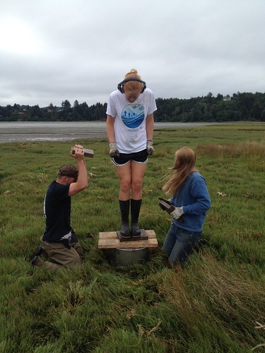
Pounding in cores at Aquarium Marsh today

My work here in the marshes of Oregon has been challenging in ways I would not have imagined when I applied for the position. Not only have I dealt with the rigors of science in the field, but I have learned a number of survival skills. The picture above shows me using my weight to help with the pounding of the cores. Even though this job does not require physical strength, it does require bravery. (Though I don’t look very brave in this picture!) There is something unnerving about two 40 lbs. weights getting slammed three inches from your feet while two plywood boards holding you up gradually slip apart and the platform beneath you drops an inch each jolt. I have never felt an earthquake before, so perhaps this experience will prepare me a bit.

I have been informed that in the event of an earthquake within twenty miles offshore, the ground at Hatfield Marine Science Center will liquefy and we’ll have a heck of a time getting to high ground before the tsunami hits. My training in the mudflats of Yaquina Bay has given me some preparation for this. Friday we went up river from HMSC to a piece of marsh that had a great stretch of mud we had to cross to get to it. The plan was to take us three interns and the rest of the gear across the mudflat on the hovercraft from the boat. Once we were all piled in, we realized the hovercraft would not move. So Dave, our ever so kind driver, told Taylor and I to get out. Immediately upon stepping out, the mud swallowed Taylor’s leg. I helped pull her out, then walked a few steps away and I started sinking too. It’s a scary feeling being trapped like that. But you have to be patient. If you get too anxious and pull out too fast you can tear your leg muscles and ligaments. Jody, our dedicated lab tech, helped me out then gave me some quick advice for how to walk on mud. Lightly. Just glide across. Walk on the balls of your feet. Don’t stay in one place too long. So I could either stay and wait for the hovercraft to get me and sink possibly further, or charge across the mudflat with my own two feet. I decided the second option. So I made a run for it, sinking in four inches each step, feeling near doing a face plant multiple times. Once across, I was out of breath and exhilarated, having conquered a fear I had all summer!

I have also learned a few other potentially useful non-science skills. I know how to tie a boat to a dock, how to attach the boat to the trailer, and how to operate a jack to most efficiently pull cores out of the ground. It is nice learning to be more handy.

Today we did our last day at Aquarium Marsh, which is sad. I am busy now trying to collect the data into a spreadsheet for my individual project studying the effects of water temperature on nutrient uptake, and finding a way to analyze it and present it. While doing this, we are still continuing the overall project as we travel to Alsea Bay tomorrow and Winant in the Yaquina Thurs and Fri.

This weekend was a great one as my family visited from Seattle and Chicago. We rented a cottage near the beach south of Lincoln City and I got to visit and explore the coast with them. I took my grandpa on an estuary walk given by a fellow scholar, Brian. My grandpa was very adamant about learning everything he could about estuaries as he is a scientist as well, though estuaries are out of his area of expertise. Also, I loved watching my baby nephew toddle along at the beaches we visited. He is great at walking in sand and will one day be a fantastic mudflat walker I’m sure.

Week 7: Phytoplankton galore!

Each week it get’s harder and harder to piece together the whirlwind that was my life in the past seven days, but here I am again to give it another shot. From what I recall, I seem to remember spending a significant amount of time with 2 liter bottles. Yes, that sounds about right. Which estuary were these bottles from though? Yaquina? Nehalem? Alsea? Umpqua? Siuslaw? A combination of the above? And what kinds of responses did they show again?

Digging deeper, I can confirm with 99.99% confidence that we conducted a phytoplankton limitation experiment with water collected from the Siuslaw estuary. While, I haven’t extracted and analyzed the chlorophyll from these samples yet, the in-vivo results seem to suggest that this particular estuary was both nitrogen and phosphorus limited in different locations. Given that the alder cover in this particular estuary was about 7.4%, compared to the largely “P” limited Yaquina which has 13.4% alder cover, this is an interesting result. Remember, alders are tremendous nitrogen fixers, and are huge source of the nitrogen that eventually ends up in these bodies of water. Looking forward to this week, we have samples from both the Nehalem system up north, and the Alsea system in Waldport. These systems have 5.15% and 7.9% alder cover respectively, so I would expect to see similar results, if not outright “N” limitation.

Alright, now to take a little step back from the data. This week will be week eight, and after this week we will have conducted a staggering six phytoplankton limitation experiments from the estuaries I listed above. Those two weeks we missed were my first week on the job, and the Fourth of July week. Other than that, I have helped conduct an experiment each week I have been here. It has been a tremendous experience, and I can’t even fathom how much I have grown as an aspiring scientist. I have also grown more and more intrigued by the field of Marine Pollution and Water Quality. It is an area of marine science which I am going to spend a considerable time investigating once I finish up this internship, and begin to contemplate graduate school programs. Alright, that’ll do it for this week. Until next time!

New survey site, habitat data, and muddy mishap

 Last week we journeyed once again into the South Slough of Coos Bay for another Cockle sampling. This time we went to Valino Island, which represents a more heterogeneous habitat than our previous survey at Indian Point. That is, the substrate at Valino Island ranges from a softer, muddier consistency to a firmer, sandier consistency whereas Indian Point is more consistently sandy. Much of Valino Island is muddy, so the raking and walking were a bit more arduous. There was also considerably more eel grass at Valino, so we wanted to take some extra care to minimize our impact on it. Nonetheless, we managed to rake up around 120 cockles, which I measured, weighed, and put into the database. The cockles seem to be less abundant in the muddy areas with eel grass and more abundant in sandier areas closer to water sources like channels and pools. We’ve thus decided to expand the study to include habitat as a factor for cockle distribution. Since we didn’t take habitat info down in our initial surveys, we took some extra time and revisited each quadrat at each site and recorded various habitat aspects: substrate type (sand, mud, smud [sand+mud]), presence/absence of eel grass, presence/absence of gaper clams. (note: for a more detailed description of our field methods, see blog entry for 7-23-2012). In my last blog entry I mentioned starting in on some stat analyses. Due to last week’s fieldwork, we weren’t able to start much in-depth interpretation, but we did decide to collect some extra cockles at each field site to boost our sample size. We randomly selected approx 20 quadrats at each site and raked up about 70 extra cockles per site. This should help beef up our data for further analyses. So far it looks like nonparametric hypothesis tests are the way to go, because our sample sizes aren’t large enough to assume a normal distribution. Something I’ve learned through these initial stat analyses is that our sample sizes need to be very large in order for standard parametric tests (T-test, ANOVA, etc) to be valid. This morning we journeyed back to Valino Island to collect habitat data and more cockles. My confidence for walking on soft mud has increased—to a fault: at one point I let my guard down, my foot got stuck, and I fell right on my backside in the mud. Luckily my chest waders saved me from total disaster. Nothing hurt but my pride, and I may have an interesting photo to share. The rest of the week I’ll be generating pivot tables, which are very helpful/powerful when looking at data (more about those later when I learn more) and doing some more in-depth stat analyses with the new habitat info.

Preparing for the end

Well it has definitely been an interesting time here at Hatfield.  We have had some bright sunny and very warm days and then it changes completely to a fog bank that makes me unable to see even the bridge that crosses over the Yaquina Bay.  This past week I did get 2 days off like regular and during that time I slept, watched olympics, did laundry and planned out more of my vacation.  At work, I got to meet some more amazing volunteers and visitors that made my time here much more fun.  I got to do some awesome aquarist work where I got to inject lemon juice (acidic) into aplasia which is a coral invasive.  Doing that, taught me a lot about how to keep a tropical fish aquarium clean and healthy.  I also was able to siphon the tank by myself, which meant I got to change the tropical water and decide how to treat it correctly.  I was also able to see Auroras beak! It was a spectacular thing to see and I may never see an octopus beak again, but now not only do I have memories of it, I also have pictorial evidence as a reminder of my sensational summer here at Hatfield.

My wave tank though is at a standstill right now.  Both my mentors and I are now at the next stage of progress that will require a lot more than just signs and sand.  We need to start making real stainless steel tables and other items that are more than I can do myself.  Which means mainly that time is now an even larger factor, but I’m hoping for all the best.  I still get to see all the different things kids imaginations make with my freshwater wave erosion tank and that still poses some fun challenges for my job.  Ocean quest keeps getting better and better as I get more and more comfortable with it.  I also get to hear more stories about the Mt. St. Helen’s eruption in 1980 which gives me more facts to talk about as the presentations keep going.  People told me how they had to wrap their air filters in toilet paper every few miles to make sure they didn’t breathe in ash as they drove to work each day.  Some said they still has ash from 1980 in the woods of their backyard. It’s crazy learning all about the different experiences people have had with volcanos and earthquakes especially when they’ve had experiences all through their lives.  Then, estuary walks are always amazing because no matter how many people you have or the age differences between the people I still always have an amazing time and I learn more and more after each estuary tour.   Also, each estuary tour is different since the tide is different from being a low tide or a high tide, and of course the people change each day.

The main things I have to look forward to are a five day weekend which involves me going to Vancouver, Canada for 3 days and then meeting up with my other housemates (kate, maryna and hillary) in Seattle for a few days.  I get to take the amtrak train on the west coast for the first time.  Everyone keeps saying I’ll see some beautiful views along the way, so I only have high hopes for the trip :)  I also can’t wait to see if more progress can be made on my wave tank while I’m gone and then when I get back.  Mainly because once I get back I only have 11 days before our final presentation to get everything together.  Wish me luck and a great vacation time!

B-roll

Last week was a busy one. On Thursday I was finally able to start shooting footage for the videos and made a trip over to HSMC where I worked with an MRM grad student and three OSG scholars. Everyone was very generous with his/her time and I can’t express enough thanks to the scholars’ patience with the camera issues. When I realized the mic and camera were not compatible, Mark saved the day and I ended up shooting everything on a handi-cam. Probably not the most ideal choice, but given that I was an hour away from any equipment, it was definitely the best choice. After the camera snafu, the day picked up and I worked straight through until about 4 p.m. filming people in their work environments and interacting with other students and visitors.

Overall, I’m getting excited to see how all of the interviews will be connected. Everyone seems to enjoy the work they are doing and gave great answers during the interviews. Unfortunately, the only problem I see now is figuring out how to pare down all of the material into one three-minute video.

Help me out…be curious

Good estuary tours

As mentioned in previous blog posts, one of the main jobs for the interns at the Visitor Center is giving estuary tours to the public at 11am.  Diana, Nick, Julie, and I trade off giving these tours depending on who wants to do it on a particular day.  It’s not uncommon for one of us to give tours multiple days in a row when the other person is doing the Ocean Quest presentation for that day.   In general, I prefer to do the Ocean Quest presentation because it is very structured and straightforward.   There are very few surprises during the presentation. On the other hand the estuary tours are very unstructured and vary in topic from day to day.  This has its ups and downs and can make them pretty challenging.  In this blog post I am going to outline what a good estuary tour is like.

To start out with, I’ve found the number of people on the tour doesn’t really matter too much.  The level of engagement of the group is what really defines a good estuary tour.  I think this can be said of many things in life (I’m sure any teacher/professor could say the same thing).  I have just come to realization because of these estuary tours.  So step one, get an engaged group.  I usually take my tour through the doors leading to the education wing where I can then introduce myself outside the hustle and bustle of the Visitor Center.  I then usually head to the tank farm outside where I can give some interesting facts about HMSC such as the number of scientists working, the number of federal and state organization, etc.  Today was particularly cool because Dr. John Chapman, HMSCs Invasive Species Specialist, was at the tank farm.  He gave the tour a very cool rundown of what the current situation is with the Japanese dock that washed ashore earlier this year.  Nothing quite gets a group jazzed like a world-class researcher giving you a rundown on what’s going on in the biology world.

I then usually head past the US Fish and Wildlife building to the estuary trail and head to the mudflats.  I like to stop at the transition between the highlands and the salt marsh to explain how some plants have adapted to a salty environment.  There is a very distinct visible line where shrubs and trees stop growing and salty plants begin to grow.  I really like looking at this line and then heading down to eat some of the salt-adapted plants.  I try to get everyone to eat pickleweed which just tastes like salt.  After that little adventure we make our way down to the mudflat where we suck out some shrimp with a slurp-gun.  Nobody enjoys sucking shrimp out more than the kids.  They could do this for hours (I have actually had a family do this for an entire hour).  If the crowd looks up to it I head to the part of the estuary trail that has eroded and explain the different forces at work that cause erosion on an estuary and explain different techniques to mitigate erosion.

Lastly I’ll head to the water storage tank and to the saltwater stream and explain how the tank has more water in it than an Olympic sized swimming pool and the saltwater stream is unique because it’s a saltwater stream.  Then we’ll head back and call it a tour.

As I mentioned earlier what really makes a tour successful in my eyes is when the group is interested and engaged.  The more questions the better.  Everyday I hope that my group will be excited to learn about this stuff because it makes the tour way more enjoyable for me.


Cascade Head

This week I changed sites from Cape Perpetua to the future marine reserve location at Cascade Head. On Tuesday, Melissa and I drove around area to scout out the best locations to do pressure counts. We figured out that the reserve basically spans the entirety of Lincoln City and around the Salmon River and Cascade Head. This site  isso different from Cape Perpetua, because it is located in one of the most urban areas on the coast rather than in the middle of a forest.

I quickly noticed that giving surveys in this area was much different than Cape Perpetua as well. I started giving surveys in the parking lot of a huge beach in the heart of Lincoln City called “DRiver” and I was disappointed to find that more people refused to take the survey that day than perhaps the entirety of people I asked at Cape Perpetua. I think this crowd was headed straight to the beach and not interested in hanging out in the parking lot. On the bright side, hundreds of people pass through that area in an hour, so I still had no problem finding people to interview. The surveys showed that visitors to Lincoln City tended to include more families, locals, and day-travelers than Cape Perpetua. When I explained this to Melissa, she recognized that there might be some bias in our survey in this area due to the fact that I was only interviewing people coming from a parking lot and would therefore never sample people who had simply walked out to the beach from their rental houses/hotels. This would make the survey more biased towards locals and people on day-trips rather than multi-day visitors. To fix this bias, I started interviewing people on the beach, which actually turned out to be very efficient, because people were stationary, relaxed, and much more willing to take the survey so I could just jump from group to group.

The part of the Cascade Head reserve that is the most contentious is the area of the ocean directly beyond the Salmon River Estuary. Fishermen claim that they travel out beyond the large sandbar that marks the boundary between the estuary and ocean, so therefore a marine reserve in this area would affect them greatly. People at the ODFW are skeptical that they travel to this area often, because the bar is very difficult to navigate. I am helping to answer this question by observing whether or not there are boats beyond the bar at the mouth of the estuary. Also, I ask all fishermen that I at Knight Park (the boat launch area for the estuary) whether they fished in the ocean or stayed in the estuary. I can see that questioning these fishermen has the possibility of being a little tricky, but so far it has gone well!