Funding Opportunity: Sea Grant Aquaculture Research Program 2012 Request for preproposals

NOAA Sea Grant has announced a funding opportunity for its Aquaculture Research Program 2012 to support the development of environmentally and economically sustainable ocean, coastal, or Great Lakes aquaculture.

Priorities for this FY 2012 competition include: Research to inform specific regulatory decisions; Research that supports multi-use spatial planning; and Socio-economic research targeted to understand aquaculture in a larger context. Proposals must be able to express how the proposed work will have a high probability of significantly advancing U.S. marine aquaculture development in the short-term (1-2 years) or medium-term (3-5 years).

To view the full announcement Go to www.grants.gov and perform a basic search using the Funding Opportunity Number: NOAA-OAR-SG-2012-2003249.

This is a two-stage competition, with preproposals and full proposals. Each stage has specific guidance and deadlines, stated in the announcement, with Preliminary Proposals due 2/7/2012, and Full Proposals due 4/17/2012. Applicants must submit a preproposal in order to be eligible to submit a full proposals. Preliminary Proposals are to be submitted directly to the National Office via e-mail.

Pay careful attention to the instructions and contact Sarah Kolesar, Research Coordinator for the Oregon Sea Grant Program (sarah.kolesar@oregonstate.edu, 541-737-8695) as soon as possible to discuss proposals.

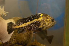
Fish sanctuary takes shape off Port Orford

China RockfishPORT ORFORD  – As a new marine sanctuary takes shape off the coast of this southern Oregon town, researchers are using the area to study the life cycles and feeding patterns of rockfish and other species, in an effort to understand how much space a fish population needs to thrive.

Public Radio International’s Living on Earth looks at the work of OSU biologist and graduate researcher Tom Calvanese, who’s getting assistance from local fishermen as he works to learn more about the fish and their needs.

This unusual alliance between fishermen and scientists is becoming more common on Oregon’s coast, thanks in part to Oregon Sea Grant’s decades-long efforts to bring the two groups together to benefit from each other’s knowledge.

Read and listen to the Living on Earth episode.

(The episode was originally produced for Ocean Gazing, an ocean-science podcast produced by Ari Daniel Shapiro for COSEE NOW (the Centers for Ocean Sciences Education Excellence – Networked Ocean World.)

PBS features OSU tsunami-proofing research

PBS Newshour’s Science Thursday looks at research occurring in Japan and the US to try to harden coastal communities against the human loss and devastation caused by powerful tsunamis. Featured research includes work being done by Dan Cox’s team at OSU’s Hinsdale Wave Research Center on potential vertical evacuation towers:


(Text transcript here)

Learn more about Sea Grant-supported tsunami research and public education

Free-choice lab launches blog

Welcome Oregon Sea Grant’s Free-Choice Learning Lab to the blogosphere!

The lab, based at OSU’s Hatfield Marine Science Center in Newport, employs cutting-edge research tools and technologies to study informal science learning. The knowledge will be put in practice in the form of  new and improved exhibits in the HMSC Visitor Center, which is managed by Sea Grant.

The blog,  launched last week, will to record the work of graduate research assistant Harrison Baker and other graduate students as they design, build, test and refine the new exhibits.

Under the direction of Dr. Shawn Rowe, Sea Grant’s Free-Choice Learning program specializes in conducting and applying  research on the  learning that happens when people choose to visit science museums, zoos, and aquariums in their leisure time, making specific and conscious choices about what they learn. The program was recently awarded a $2.6 million, five-year, National Science Foundation (NSF) grant – the largest ever received by Sea Grant –  toward the creation of  the new lab, which will employ the Visitor Center’s exhibits as tools for studying how people learn in a free-choice environment.

Sea level rise, increasing storms and the Pacific coast

Storm waves hitting central Oregon coastNEWPORT – Oregon State University geoscientist Peter Ruggiero will speak at the Hatfield Marine Science Center tonight (Oct. 25) on “The Role of Sea Level Rise and Increasing Storminess in PNW Coastal Change and Flood Hazards.”

The talk starts at 7 pm in the Hennings Auditorium at the HMSC Visitor Center.

Ruggiero is part of a team of scientists from OSU and the Oregon Department of Geology and Mineral Industries who have been studying increased storm activity and resulting wave height off the Oregon coast, and its effects on erosion, flooding and other hazards.

This past January, the team published an assessment suggesting that maximum heights could be as much as 40 percent higher than previous record levels, especially in the stormy winter months of December and January.  The report said that the cause of these dramatically higher waves is not completely certain, but “likely due to Earth’s changing climate.”

Combined with the effects of sea level rise, higher maximum waves could have implications for erosion, flood control, property damage and development regulations up and down the Pacific Northwest coast.

Ruggiero’s team has received support for its work from Oregon Sea Grant (2008-2010) and from the NOAA Climate Program.

Marine educator blogs from shipboard

Bill Hanshumaker, Sea Grant’s marine educator at the Hatfield Marine Science Center, is blogging from sea off the Pacific coast this week as he travels with scientists seeking to learn more about seafloor geology and earthquakes.

The team is traveling aboard OSU’s R/V Wecoma with a crew from the Cascadia Initiative, an onshore/offshore seismic and geodetic experiment that studies questions ranging from megathrust earthquakes to volcanic arc structure to the formation, deformation and hydration of the Juan De Fuca and Gorda plates.

The team takes advantage of an Amphibious Array of 60 ocean-bottom sensors installed with funding from the 2009 US Recovery Act to improve undersea earthquake monitoring and advance our understanding of geologic processes in the seismically active region off the coasts of Oregon, Washington and Northern California. The system also includes onshore GPS stations and earthquake monitoring instruments. Participating institutions include Columbia University, IRIS, Scripps Institution of Oceanography, Woods Hole Oceanographic Institution and UNAVCO, a nonprofit consortium of universities supporting geoscience research and education.

This is the third major research cruise over the past decade for Dr. Hanshumaker, who has been educating the public about science for 16 years at the HMSC Visitor Center, and before that, at the Oregon Museum of Science and Industry.  In 2005 and 2006, he joined  the Sounds From the Southern Ocean cruises with a team led by NOAA/OSU researcher Bob Dziak, who is also one of the principle investigators on the current project.

As he’s done on previous research voyages, Bill is blogging about the voyage, the research and the research team, this time from http://blogs.oregonstate.edu/billgoestosea.

Shipboard blogging can be a challenge, thanks to a hectic research schedule and unpredictable Internet access, but Bill is posting as time and conditions permit, and also plans to share the experience with Visitor Center audiences on his return to Newport.

Register for the Coastal and Marine Spatial Planning Science Workshop

Registration is now open for the OSU Marine Council and Oregon Sea Grant sponsored Coastal and Marine Spatial Planning Science Workshop. The workshop will be held November 29-30 at the OSU Alumni Center, and is open to all Oregon academic faculty. You can find out more information, register for the workshop, and register to give a brief presentation about your research at the following website:

http://oregonstate.edu/conferences/event/cmspworkshop

Volcanic vents offer peek at acidic future

The underwater volcanoes off a tiny Italian island are helping scientists peer into the future of a world altered by increasing amounts of carbon dioxide emitted into the air and absorbed into the oceans.

The waters just off the island of Ischia mirror the projected conditions of the Earth’s oceans at the beginning of the next century because the volcanic vents found there infuse the water with large helpings of carbon dioxide, or CO2, which turns seawater acidic.

Research has shown that the growing acidic conditions are harmful to some sea creatures — those that build their protective shells with calcium are increasingly prevented from doing so the more acidic waters become.

The fates of these creatures and the stability of the ocean food chain are a major concern over the next century and beyond because of the carbon dioxide being released into the atmosphere by humans, as the oceans absorb about 30 percent of this carbon dioxide.

“One part of climate change that is indisputable is that CO2 is rising in the atmosphere — it’s easy to measure,” said Bill Chadwick, an Oregon State University geologist. “And it’s indisputable that it is making the oceans more acidic — we can measure it.”

(Oregon Sea Grant has supported previous deep-sea research projects by Dr. Chadwick).

New on DVD! Cascade Head / Scenic Research Area

Cascade HeadGrab your hiking boots and binoculars! This video will take you on a scenic and historical walk through the beautiful prairie headlands, forests, and grassy marshes of Cascade Head and the adjoining Salmon River estuary.

Ever heard of Pixieland? Kami Ellingson, from the Siuslaw National Forest, will take us on a guided tour of the complex history of commercial and residential developments that once threatened to pave paradise.

Stay on the trails, because that little blue violet up on the headlands feeds the Oregon silverspot caterpillar, one of four threatened or endangered animal species that live here. The Nature Conservancy’s Debbie Pickering tells us the butterfly’s story.

Back in the marshes, NOAA Fisheries scientist Dan Bottom describes the history of a massive habitat-restoration project, in which dikes were removed from the estuary in the hope of improving salmon runs. Western Oregon University Professor Karen Haberman shares her Sea-Grant sponsored research in the marsh–an unusual focus area with surprising consequences.

And finally, Eric Vines gives us a tour of the Sitka Center for Art and Ecology, one of the many recreational opportunities at Cascade Head.

The full program is available on DVD from the Oregon State University Marketplace

Exclusive: Watch a short featurette not included on this DVD: Salmon River Marsh / Undergraduate Field Experiences (about 2 mins)


Scientists accurately predict undersea eruption

NEWPORT, Ore. – The undersea geology world is buzzing about the recent discovery that the Axial Seamount – an undersea volcano about 250 miles off the Oregon coast – has erupted. But what has everyone excited is that the eruption had been forecast by a team of scientists who’ve been monitoring the mount for years.

It’s being called the first-ever successful forecast of an undersea volcano.

Bill Chadwick, an Oregon State University geologist based at the Hatfield Marine Science Center, and Scott Nooner, of Columbia University, have been monitoring Axial Seamount for more than a decade, and in 2006 published a paper in the Journal of Volcanology and Geothermal Research in which they forecast that Axial would erupt before the year 2014. Their forecast was based on a series of seafloor pressure measurements that indicated the volcano was inflating.

“Volcanoes are notoriously difficult to forecast and much less is known about undersea volcanoes than those on land, so the ability to monitor Axial Seamount, and determine that it was on a path toward an impending eruption is pretty exciting,” said Chadwick, who was chief scientist on the recent expedition, which was jointly funded by the National Oceanic and Atmospheric Administration and the National Science Foundation.

Axial last erupted in 1998 and Chadwick, Nooner and colleagues have monitored it ever since. They used precise bottom pressure sensors – the same instruments used to detect tsunamis in the deep ocean – to measure vertical movements of the floor of the caldera much like scientists would use GPS on land to measure movements of the ground. They discovered that the volcano was gradually inflating at the rate of 15 centimeters (six inches) a year, indicating that magma was rising and accumulating under the volcano summit.

When Axial erupted in 1998, the floor of the caldera suddenly subsided or deflated by 3.2 meters (10.5 feet) as magma was removed from underground to erupt at the surface. The scientists estimated that the volcano would be ready to erupt again when re-inflation pushed the caldera floor back up to its 1998 level.

“Forecasting the eruption of most land volcanoes is normally very difficult at best and the behavior of most is complex and variable,” said Nooner, who is affiliated with the Lamont-Doherty Earth Observatory. “We now have evidence, however, that Axial Seamount behaves in a more predictable way than many other volcanoes – likely due to its robust magma supply coupled with its thin crust, and its location on a mid-ocean ridge spreading center.

“It is now the only volcano on the seafloor whose surface deformation has been continuously monitored throughout an entire eruption cycle,” Nooner added.

Read more from: