First confirmed tsunami debris hits Oregon shores

AGATE BEACH – A chunk of concrete and steel that washed ashore Tuesday on this central Oregon coastal beach has been confirmed as a floating dock swept off the coast of Japan by last year’s devastating tsunami.

It is the first confirmed landing of tsunami debris on the Oregon coast. Scientists and governments have been tracking debris in the 15 months since the disaster, and expecting items to begin making landfall on the West Coast this summer.

According to The Oregonian, a plaque on the 66-foot-long section of debris helped the Japanese Consulate in Portland identify it as a dock cut loose in Misawa, a northern Japanese city struck by the powerful tsunami waves on March 11, 2011.

“It’s one of four floating docks washed away by the tsunami, which means there are three more floating somewhere possibly,” said Hirofumi Murabayashi, deputy consul general. “In Oregon this is the first item obviously from the tsunami.”

The consul has turned the matter over to the Oregon Department of Parks and Recreation, which has jurisdiction over the beach, to determine what to do about the chunk of debris, which measures 66 feet long by 19 feet wide by 7 feet tall.

Read the entire story in The Oregonian

OSU unveils new maps of Oregon ocean

Map of sea floor off Cape AragoCORVALLIS – After more than two years of intense field work and digital cartography, researchers have unveiled new maps of the seafloor off Oregon that cover more than half of the state’s territorial waters – a collaborative project that will provide new data for scientists, marine spatial planners, and the fishing industry.

The most immediate benefit will be improved tsunami inundation modeling for the Oregon coast, according to Chris Goldfinger, director of the Active Tectonics and Seafloor Mapping Laboratory at Oregon State University, who led much of the field work.

“Understanding the nature of Oregon’s Territorial Sea is critical to sustaining sport and commercial fisheries, coastal tourism, the future of wave energy, and a range of other ocean-derived ecosystem services valued by Oregonians,” Goldfinger said. “The most immediate focus, though, is the threat posed by a major tsunami.

“Knowing what lies beneath the surface of coastal waters will allow much more accurate predictions of how a tsunami will propagate as it comes ashore,” he added. “We’ve also found and mapped a number of unknown reefs and other new features we’re just starting to investigate, now that the processing work is done.”

The mapping project was a collaborative effort of the National Oceanic and Atmospheric Administration, OSU’s College of Earth, Ocean, and Atmospheric Sciences, David Evans and Associations, and Fugro. It was funded by NOAA and the Oregon Department of State Lands.

The primary mapping platform was the vessel Pacific Storm, operated by the OSU Marine Mammal Institute. Oregon-based fishing vessels taking part in Oregon Sea Grant’s Scientist and Fisherman Exchange program – the F/V Michelle Ann, the F/V Delma Ann, and the F/V Miss Linda – assisted with ground truth sampling and video surveys.

Netcasts – Pat Corcoran, Coastal Hazards Specialist

In this episode of Netcasts, we travel to Astoria to visit Pat Corcoran, coastal hazards specialist for Oregon Sea Grant Extension.   Corcoran works with coastal community members and researchers around the world to prepare coastal residents for natural hazards, such as erosion and tsunamis.  Corcoran talks about his experiences bringing the findings of research conducted by OSU’s Peter Ruggiero to the community of Neskowin, where residents are exploring strategies to mitigate shoreline retreat.  Corcoran also shares some photographs and wisdom from his recent visit to Japan, where he was able to view the aftermath of the March 2011 tsunami.  Stay tuned to Sea Grant’s YouTube channel for more Netcasts.


State rolls out new tsunami hazard maps

Coos Bay tsunami mapThe state has issued the first of a planned series of 80 new, high-resolution maps that graphically illustrate the risks of tsunamis on the Oregon coast, this one covering Coos Bay.

The 48-by-52-inch map, published this week by the Oregon Department of Geology and Mineral Industries (DOGAMI) shows in great detail which low-lying areas around Coos Bay are greatest at risk for tsunami inundation, by either a near-shore Cascadia Subduction Zone earthquake or a more distant quake that sends waves traveling across the sea.

The agency is in the process of upgrading all its coastal tsunami maps, first produced in the early 1990s, to “incorporate all the best tsunami science that is available today,” according to a DOGAMI news release announcing the new map.

The map, in a printable, high-resolution format, is available on CD for $10.

The new, more detailed maps are based on the geologic record of previous tsunamis, as well as knowledge gained from recent earthquakes in Sumatra (2004), Chile (2010) and Japan (2011). They include projected tsunami wave height time series charts and a measurement of the exposure each community has to various tsunami scenarios, including a count of the number of buildings that would be inundated under each scenario. Evacuation routes are also shown.

DOGAMI has been working with many collaborators, including Oregon Sea Grant, to get the new maps produced and in the hands of the public, planners, emergency managers, elected officials and other local decision makers. The effort is tied to  NOAA’s National Tsunami Hazard Mitigation Program, which DOGAMI administers in Oregon.

The agency plans to release additional maps as soon as they are ready, with a goal of having new maps for the entire coast by the middle of next year. The next set, due for release in February, will cover the North Coast from Netarts to Rockaway Beach, including Tillamook.

Read more:

PBS features OSU tsunami-proofing research

PBS Newshour’s Science Thursday looks at research occurring in Japan and the US to try to harden coastal communities against the human loss and devastation caused by powerful tsunamis. Featured research includes work being done by Dan Cox’s team at OSU’s Hinsdale Wave Research Center on potential vertical evacuation towers:


(Text transcript here)

Learn more about Sea Grant-supported tsunami research and public education

Interactive tsunami inundation maps online

NANOOs Tsunami Evacuation pageNew, interactive maps pinpointing how and where a tsunami might flood the Oregon and Washington coastlines – and the closest uphill evacuation spots – are online now at NANOOS, the Northwest Association of Networked Ocean Observing Systems.

The new Tsunami Evacuation Zone portal is a joint project of the Oregon Department of Geology and Mineral Industries, Washington Department of Natural Resources, and  the NANOOS Visualization System team.

The new maps allow users to enter an address, or click on the map, and see if their location is in a danger zone. Users can create multiple places, and if they sign up for a free myNANOOS account, save their own personalized maps for future use.

The maps show areas projected to be at risk of flooding by close and distant tsunamis, and the approximate time residents would have to evacuate those areas before the waves arrive. They also show nearby areas of high ground where residents and visitors can expect to be out of the reach of the incoming water.

All low-lying coastal areas, harbors, streams, and rivers in Oregon are vulnerable to tsunami inundation.  While the waves from distant earthquakes like the one that struck Japan in March 2011 can take several hours to arrive, a sea-floor earthquake in the seismically active Cascadia Subduction Zone, just off the coast, could generate devastating waves in a matter of minutes. Undersea landslides can also generate powerful, localized tsunamis.

Recent research suggests that powerful near-shore quakes have occurred off the Oregon coast at relatively regular intervals; scientists now put the chance of a magnitude 8-9 earthquake striking the region  at 37% within the next 50 years.

The new NANOOS site is tied to NOAA’s  West Coast and Alaska Tsunami Warning Center, and displays earthquake and tsunami alerts in real time. It also contains printable PDF versions of local tsunami evacuation brochures for specific coastal communities in Oregon and Washington. The brochures are also widely available in printed form at visitor centers, motels and other locations on the coast.

A powerful nearshore earthquake could disrupt communications, including Internet service, on the coast. The site emphasizes preparing in advance:  Developing family and workplace evacuation plans, obtaining or printing out evacuation brochures, walking local evacuation routes, and figuring out how you will reconnect with family members once the immediate danger has passed.

For more information about tsunami preparedness, visit Oregon Sea Grant’s Coastal Natural Hazards page.


Debris from Japanese tsunami slowly making its way toward West Coast

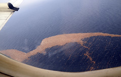
Debris from Japanese tsunami floats in Pacific in mid MarchA massive trail of debris from the devastating tsunami that struck Japan on March 11 is slowly making its way across the Pacific Ocean en route to the West Coast of the United States, where scientists are predicting it will arrive in the next two to three years – right on schedule.

The mass of debris, weighing millions of tons and forming a trail a thousand miles long, will likely strike Oregon and Washington, according to models based on winds and currents.

But new accounts of where the trail has progressed suggest that at least some of that debris may peel off and enter the infamous “Garbage Patch,” a huge gyre in the Pacific where plastic and other debris has accumulated over the years, according to Jack Barth, an Oregon State University oceanographer and an expert on Pacific Ocean currents and winds.

“Recent reports of debris are from farther south than the axis of the main ocean currents sweeping across the north Pacific toward Oregon,” said Barth, a professor in OSU’s College of Oceanic and Atmospheric Sciences. “This means a fair amount of debris may enter the patch. We should still see some of the effects in Oregon and Washington, but between some of the materials sinking, and others joining the garbage patch, it might not be as bad as was originally thought.”

Read more from OSU News & Research Communications

(Photo courtesy of  US Pacific Fleet gallery on Flickr)

Outside magazine profiles Sea Grant’s Pat Corcoran

PITY POOR CASSANDRA, blessed by Apollo with the power of prophecy, cursed with the fate of ­disbelief. She tells the people what’s coming. She suffers their laughter, absorbs their scorn. Then she watches her prediction come true. Yeah, you told us so, they’ll say as they bury the dead. Congratulations, jerk.

Patrick Corcoran feels her pain. It’s his job. Every day, he rises at dawn and goes out into the world to tell people to prepare to meet their doom. Or, rather, to prepare to escape it.

Corcoran is a professional geographer in Astoria, Oregon, a misty fishing port where the Columbia River meets the ­Pacific Ocean. He’s a high-energy guy, 50, with a little ­Billy Bob Thornton to his look. Loves his job and loves his coffee. Drives around in his ­Toyota ­Tacoma all day with an 11.5-foot-long Taka­yama paddleboard strapped to the rack. He’s a coastal natural-hazards specialist with Ore­gon Sea Grant, a marine version of an agri­cul­tural extension service affiliated with ­Oregon State University. Cor­coran prophesies earthquakes and tsunamis five days a week. …

(Read the whole article at Outside Online...)

A Tsunami on the Columbia

What might happen if a nearshore tsunami caused by a local earthquake were to travel from the Oregon coast up the Columbia River? That was the focus of a recent research workshop funded by Oregon Sea Grant at Oregon State University (OSU), August 15-16.

“We know tsunamis can penetrate along rivers for long distances,” said OSU tsunami expert Harry Yeh, the workshop organizer. But, said Yeh, tsunami penetration up rivers has been largely unexplored until now.

“In the coastal plain they [tsunamis] can penetrate 2 to 5 kilometers [about 1 to 3 miles], but with the river they can penetrate up to 10 kilometers [about 6 miles] no problem.”

The Oregon Coast lies along the Cascadia subduction zone, a fault line that stretches from Northern California to British Columbia. The Cascadia subduction zone is similar to the subduction zone that caused Japan’s recent earthquake and tsunami. A magnitude 9.0 earthquake occurs along the Cascadia subduction zone once every 300-500 years. It had its most recent earthquake in 1700. This expected earthquake would most likely be accompanied by a tsunami, which could affect the Columbia River, said Yeh.

The 18 workshop attendees were asked by Yeh to model a section of the Columbia that stretches from Astoria, Oregon at the coast all the way to the Bonneville Dam. Yeh said the idea was to gather general data that could be used in future tsunami modeling.

“We are not trying to do detailed models of say Astoria or Longview, for instance,” said Yeh.  “Though, I think that’s next step.”

Many of Oregon’s coastal communities could one day feel the affects of a tsunami. Communities that could be flooded or inundated by tsunamis have been mapped by the Oregon Department of Geology and Mineral Industries into inundation zones. But these inundation maps don’t include the Columbia, said Yeh. Instead the maps stop at Astoria, which lies at the mouth of the Columbia. The workshop’s exploration of what might happen if a Tsunami penetrated the Columbia could change how tsunami inundation maps are made in the future, said Yeh.

“This work is very theoretical, very academic, but it has direct consequences and real applications, which is why I feel like this is important work,” said Yeh.

Events at the recent workshop included presentations by Yinglong Joseph Zhang of Oregon Health and Science University on how far a tsunami could penetrate the Columbia, as well as a presentation by David Jay of Portland State University, on the hydrodynamics of the river. Workshop discussions also included comparing different tsunami modeling techniques including those used by the National Oceanic and Atmospheric Administration (NOAA) and those used by the Japanese government.

Of particular interest to Yeh himself is a stretch of the Columbia that starts at Astoria and follows the Columbia until it turns south toward Portland at Longview, Oregon. Yeh says the bathmetry, or depth of the water in this area is very complex and includes marshes, and islands and other complex topography, which makes modeling complex. The islands, marshes, and other elements of the river’s landscape will play into what is known as the friction effect, which Yeh lead a discussion on during the workshop.

Yeh’s workshop also examined the affect the movement of the tide could have on a tsunami traveling from the Pacific Ocean to the Columbia River. Whether the tide is coming in or out could be very important, said Yeh.

Of particular interest to researchers at the workshop was whether a tsunami could reach Portland, Oregon.

“Even in the Portland area residents could feel the affects of a tsunami,” said Yeh. “Although this affect is going to be very small, it is going to be measurable.”

Yeh recently returned from Japan where he witnessed the results of the earthquake and tsunami that devastated the country, including how the recent tsunami traveled up the Kitakami River.

Yeh, who started studying tsunamis in 1985, saw the results of a tsunami first hand in 1992 after a large tsunami hit Nicaragua. His past research has included Oregon Sea Grant funded work with fellow OSU Professor Daniel Cox. In 2009, Cox created a model of the coastal Oregon city of Seaside that he, with the help of Yeh, then inundated with a simulated tsunami using the university’s O.H Hinsdale Wave Research Laboratory, a facility that contains a wave machine capable of creating scaled facsimiles of tsunamis. The model town received a scaled-down version of a tsunami that could hit Seaside if the Cascadia subduction zone experiences a 9.0 magnitude earthquake.

Yeh said the workshop went well and has resulted in a further collaboration between himself and several workshop attendees.


Sea Grant’s Jeff Feldner on seafood and Fukushima radiation

Oregon Sea Grant Extension fisheries specialist Jeff Felder is interviewed by Russia’s RIANOVOSTI news about US concerns for seafood safety in the aftermath of the disaster at Japan’s Fukushima nuclear reactors. Jeff’s assessment: While it’s likely detectable increases in seafood radiation levels will eventually show up in Pacific Northwest waters, it’s too early to tell how soon it will happen or how high the levels will be. The research he’s seen suggests the radition is unlikely to reach levels dangerous to consumers.

Watch the interview: