About kightp

Pat Kight is the web and digital media specialist for Oregon Sea Grant at Oregon State University.

OPB highlights Sea Grant researcher

Oregon Sea Grant’s Guillermo Giannico and his study of the role flooded farmlands can play in fish survival are the subject of a new episode of Oregon Field Guide, broadcast on on Oregon Public Television this week.

Giannico, a fisheries ecologist with OSU’s Department of Fisheries & Wildlife who also serves as Sea Grant Extension fisheries specialist, was part of a team that set out a few years ago to learn whether dry-all-summer ditches that criss-cross Willamette Valley agricultural lands might house fish during the wet winter months.

What they found surprised them – and some of the farmers, too: A thriving winter habitat for several species of native fish.

Watch the Oregon Field Guide video, Ditch Fish:

More information:

Port Orford launches national tour of Ocean Frontiers film

PORT ORFORD  – Ocean Frontiers, a new feature-length film about ocean management and conservation, will launch its national tour in Port Orford,  which stars in the film as an example of how science and fishing can work together to manage marine resources.

The debut screening starts at 5 pm Saturday, Feb. 11 at the Savoy Theatre in downtown Port Orford. followed by a reception in the nearby Community Building, with Oregon Governor John Kitzhaber,  First Lady Cylvia Hayes, representatives of state and local government and members of the Port Orford Ocean Resource Team (POORT) expected to attend. A second screening is scheduled for  4 p.m. Sunday.

Tickets are $10 and are available only online, at www.oceanfrontiersportorford.eventbrite.com

The film will also be shown at the Performing Arts Center in Newport at 7 pm Feb. 22.

Port Orford is one of several US coastal communities featured in the 80-minute film, which tracks the evolution of marine resource management from a “maximum allowable catch” approach to a growing recognition that resources are finite, and need to be managed for the future as well as the present. The film explores the shift toward  ecosystem-based management and marine spatial planning tools that rely on science, and an informed and engaged public. Communities from the Pacific Northwest to Boston Harbor, the Florida Keys, the Gulf of Mexico and even the cornfields of Iowa are featured.

POORT figures prominently in the film as an example of how resource users,  scientists, conservationists and others can work together to help understand, protect and manage ocean areas for the benefit of the resource – and the people who depend on it. Ongoing collaboration between fishermen and scientists in the south coast community was a strong factor in the state’s decision to establish one of Oregon’s first marine reserves at Redfish Rocks, just off  Port Orford.

Oregon Sea Grant has supported the community-based effort since its early days, helping bring fishermen and scientists together and providing information and assistance as the group grew and evolved. Sea Grant helped the community design and conduct surveys and interviews that let the town  build its first  long-form community profile to give resource managers greater insight into how fisheries reach deep into the community’s social and economic life. The format and interview has since been applied to other Oregon coastal towns, and is proving to be a model for communities  elsewhere in the US.

Learn more:

Watch a 10-minute trailer for the film:

Follow the R/V Oceanus on her voyage to Oregon

R/V Oceanus departing WHOI, Jan. 25The newest addition to Oregon State University’s research fleet, the R/V Oceanus, entered the Panama Canal today to make the transit from the Atlantic Ocean to the Pacific, marking roughly the mid-point of the trip from her former home port at Woods Hole Oceanographic Institution to her new home at OSU’s docks in Newport, Oregon.

You can follow the trip via a live Webcam, courtesy of OSU Information Services, at

http://webcam.oregonstate.edu/oceanus/

The image and map update every few minutes, as long as the ship’s satellite uplink permits. An attached map even tracks the ship’s position by latitude and longitude (although the “larger view” map is still labeled with the name of the R/V Wecoma, the vessel the Oceanus will replace).

The Oceanus left Woods Hole on Jan. 25, and is expected to arrive in Newport in mid-February.

(Photo by S. Sutherland)

Sea Grant teams with state agencies to prepare for Japanese quake debris

Model of possible debris dispersal - image courtesy of NOAA

Model of possible debris dispersal (image courtesy of NOAA)

As the one-year anniversary of Japan’s devastating earthquake and tsunami nears, Oregon Sea Grant is teaming with state and local agencies, non-governmental groups and marine scientists to prepare for the possible arrival of earthquake debris on Oregon shores.

In a conference call this week, the group heard that state and county leaders, OSU Extension and the Hatfield Marine Science Center are receiving growing numbers of  questions about the debris currently floating toward US coastlines, and began charting a communication strategy to help answer those questions.

OSU oceanographer Jack Barth, an expert in ocean currents, said the debris is still months away from making West Coast landfall, although  occasional buoyant items might move more quickly.  In October, a Russian ship discovered a small Japanese fishing boat in the waters north of Hawaii, and it was definitively tied to the tsunami, Barth said. “It was about where we thought it should be, given the currents.”

Many questions about the debris have to do with concerns that it might be radioactive, given the the incidents at Japan’s Dai-ichi nuclear plant that followed the earthquake. Kathryn Higley, professor and head of the Department of Nuclear Engineering and Radiation Health Physics at OSU, said the lag time between the tsunami and the nuclear incident, coupled with the vastness of the ocean, makes it unlikely that the debris will pose any radioactive risk. The material has been tossed by wind and sea for months now, Higley said, and most traces of radioactive elements will have washed into the sea. “While we may be able to detect trace amounts of radioactive material on this debris, it’s really unlikely that there will be any substantial radiation risk,” she said.

Meanwhile, Oregon Sea Grant’s marine Extension specialists on the coast have been working with multiple public and private partners, from state and local governments to conservation and fishing industry groups, to map out a communication strategy for the debris landing.

Jamie Doyle, Sea Grant Extension specialist in in Coos and Curry counties, said one concern is what happens to personal effects that survive the ocean crossing and wind up on Oregon shores, where they may be found by beachcombers.

“A lot of people lost their lives, and many people still have family members who are missing,” Doyle said. “We need to be sensitive to the possibility of finding something that may be of personal significance to someone in Japan.”

The Seattle office of the Consulate General of Japan has asked that those who find something that could  be considered a personal keepsake or artifact report it to local authorities, or to  the consulate in Seattle at 206-682-9107.

Patrick Corcoran, Sea Grant’s Astoria-based Coastal Hazards specialist, said Oregon’s focus thus far has been on research and “building the capacity to respond” to the arrival of the debris. Specific information will be forthcoming, he said.

Learn more:


Sea Grant research: learning-based tourism could spur major growth in travel industry

Children learn about octopuses at HMSC Visitor CenterNew research suggests that major growth in the travel, leisure and tourism industry in the coming century may be possible as more people begin to define recreation as a learning and educational opportunity — a way to explore new ideas and cultures, art, science and history.

But in a recent study published in the Annals of Tourism Research, John Falk, Oregon Sea Grant Professor of Free-Choice Learning, says that increasingly affluent and educated people around the world are ready to see travel in less conventional ways, and that lifelong learning and personal enrichment can compete favorably with sandy beaches or thrill rides.

“The idea of travel as a learning experience isn’t new, it’s been around a long time,” said John Falk, an international leader in the free-choice learning movement. Falk is among a group of Sea Grant professionals focusing their research on how people learn in their free time – through travel, in museums and aquariums, and through other experiences outside conventional classrooms.

At OSU’s Hatfield Marine Science Center in Newport, Dr. Shawn Rowe and colleagues are working under a $2.6 million National Science Foundation grant to create a Free-Choice Learning Laboratory, using high-tech tools to observe and analyze use of the Center’s public aquarium exhibits and what people take away from them.

Falk, meanwhile, holds one of two Free-Choice Learning professorships established by Sea Grant with the OSU Department of Science and Mathematics Education, which has developed a masters’ degree program in the emerging discipline.

Writing in the Annals of Tourism Research, Falk and his partners from the University of Queensland, Australia explore travel as part of a  “life-long and life-wide” learning experience, tracking the history of travel-for-learning back through the centuries, and examining how the experience has grown and changed in recent times.

“You’re already seeing many tour operators and travel agencies offer educational opportunities, things like whale watching, ecotourism,” Falk is quoted as saying in an article about the new research published today in Science Daily. “The National Park Service does a great job with its resources, teaching people about science, geology and history. The push for more international travel experiences as a part of formal education for students is an outgrowth of this concept.

“We’re convinced this is just the beginning of a major shift in how people want to spend their leisure time, and one that could have important implications for intellectual and cultural growth around the world.”

Learn more:

Documentary follows Sea Grant-supported research into salmon disease

Jerri Bartholomew with juvenile salmonKLAMATH FALLS – A new documentary, airing Feb. 7 on Southern Oregon Public Television, looks at the work of an Oregon Sea Grant-funded research effort to understand more about a lethal parasite that can infect wild salmon in the Klamath River and elsewhere in the Northwest.

Dr. Jerri Bartholomew, a microbiologist and director of Oregon State University’s salmon disease laboratory, has been studying Ceratomyxa shasta since she was an undergraduate. The parasite is a major cause of mortatlity in juvenile salmon, and may infect up to 80 percent of outmigrating juveniles in the Klamath River.  Bartholomew’s work – much of it funded by Sea Grant –  has led to new understanding of the parasite’s unusual life cycle, and how changes in water temperature and other environmental factors can cause it to proliferate.

The documentary, Saving Salmon, was scripted, directed and produced by Judith Jensen, director of Educational Solutions, a Klamath Falls nonprofit. Sea Grant videographer Steve Roberts contributed footage to the project, which is scheduled to air at 9 pm Feb. 7 on SOPTV.

Read more:


New Website for Oregon Sea Grant

New Sea Grant WebsiteOregon Sea Grant has a brand new Website, with fresh content and a host of special features.

Program director Steve Brandt called it “a modern, engaging site that reflects Sea Grant’s mission and our status as an integrated program of research, education and public engagement.”

Visitors will find current news about Sea Grant’s ocean and coastal science initiatives, announcements of grant and fellowship opportunities, and profiles of Sea Grant-supported research and student scholars. Content ranges from short videos about marine safety and seafood buying  to in-depth features about critical  topics such as tsunami and climate change preparedness, marine spatial planning and invasive species.

The site provides access to hundreds of Sea Grant publications and videos – many of them free.

The site is built on the Drupal content management system, and was developed by Sea Grant communications, led by webmaster Pat Kight,  in cooperation with Oregon State University’s Web Communications and Central Web Services units.


State rolls out new tsunami hazard maps

Coos Bay tsunami mapThe state has issued the first of a planned series of 80 new, high-resolution maps that graphically illustrate the risks of tsunamis on the Oregon coast, this one covering Coos Bay.

The 48-by-52-inch map, published this week by the Oregon Department of Geology and Mineral Industries (DOGAMI) shows in great detail which low-lying areas around Coos Bay are greatest at risk for tsunami inundation, by either a near-shore Cascadia Subduction Zone earthquake or a more distant quake that sends waves traveling across the sea.

The agency is in the process of upgrading all its coastal tsunami maps, first produced in the early 1990s, to “incorporate all the best tsunami science that is available today,” according to a DOGAMI news release announcing the new map.

The map, in a printable, high-resolution format, is available on CD for $10.

The new, more detailed maps are based on the geologic record of previous tsunamis, as well as knowledge gained from recent earthquakes in Sumatra (2004), Chile (2010) and Japan (2011). They include projected tsunami wave height time series charts and a measurement of the exposure each community has to various tsunami scenarios, including a count of the number of buildings that would be inundated under each scenario. Evacuation routes are also shown.

DOGAMI has been working with many collaborators, including Oregon Sea Grant, to get the new maps produced and in the hands of the public, planners, emergency managers, elected officials and other local decision makers. The effort is tied to  NOAA’s National Tsunami Hazard Mitigation Program, which DOGAMI administers in Oregon.

The agency plans to release additional maps as soon as they are ready, with a goal of having new maps for the entire coast by the middle of next year. The next set, due for release in February, will cover the North Coast from Netarts to Rockaway Beach, including Tillamook.

Read more:

Oregon floods: fish should fare better than people

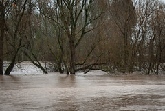
Calapooia River flooding near Albany, Jan. 20, 2012Heavy rain and melting snowpack that flooded Western Oregon last week turned creeks and rivers into broad, brown torrents that might look like bad news for fish. But an Oregon Sea Grant fisheries specialist says his research suggests the opposite.

Guillermo Giannico, a research professor in Oregon State University’s Department of Fisheries and Wildlife, has conducted studies showing that fish – especially native species – can find refuge and food in flooded grass-seed fields.

Giannico’s research grew out of a project by fellow OSU researcher Stan Gregory to map the historic path of the Willamette River. The Willamette and its many tributaries once were more complex, braided streams. Multiple channels dispersed the impact of flooding, but dams, housing developments and forest transition have since funneled many rivers into single channels that run fast and furious during floods.

Giannico and others wondered how fish adapted to the change. Floods have happened for thousands of years, he said, and fish traditionally escaped high water in the main river stems by moving to off-channel habitat.

Turns out they still do. During seasonal floods, researchers took a look at ditches, low-lying farmland and other spots that are above water most of the year. To their surprise, they found 14 fish species — 11 of them native.

“That’s high diversity for this area, more than I would have bet we were going to get,” Giannico said.

Giannico noted a couple implications from the findings. Salmon, steelhead and other native fish, he said, are keenly tuned to changes in light and water temperature, and move to sheltering habitat — even if it turns out to be a flooded grass seed field. Invasive fish, often warm-water species, don’t get it. They’re unable to respond to the clues. As a result, native fish get a temporary break from predation and competition for food.

“Floods have always been a dynamic part of the system, much the same way that snow is for elk in Yellowstone,” said Giannico  “Over time, animals will adapt to get the most out of their habitat. We have found that native fish have adjusted their behavior to use these floodplains, mostly in agricultural lands, to great benefit.”

Read more:

Sea Grant coastal erosion, climate work in Terra

High waves on the Oregon coastIncreasing winter storms since the 1980s have been sending higher, harder waves crashing into the Oregon coast, cutting away at seacliffs, roads and infrastructure in an area never known for its seismic stability. Scientists say the increased storm activity is consistent with predictions for the sorts of hazards the world’s coastlines will face as an effect of changing climate.

In Oregon, Sea Grant is partnering with communities and researchers to better understand the growing risks of coastal erosion, and to help counties and towns come up with plans for adapting to changes happening now, and predicted for the future.

In the latest issue of Terra, Oregon State University’s research magazine, Nick Houtman focuses on coastal hazard research and public engagement, highlighting the work Oregon Sea Grant is doing with Tillamook County and the town of Neskowin, where coastal hazards specialist Pat Corcoran has been working with a local group to develop the state’s first coastal hazards action plan.

Read the full article at Terra online